This is your first blog of the ohsome series? Before you might be confronted with any potential spoilers, you should better check out the first and the second part of this blog series (or the intro to the idea and … Read More
Deutsch
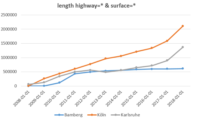
How to become ohsome part 2: Comparing different regions based on their attributive completeness of OSM data
Welcome back to the second part of the blog series how to become ohsome. If you have not read the first part yet, better go and check it out now. It explains how you can create an ohsome visualization of … Read More
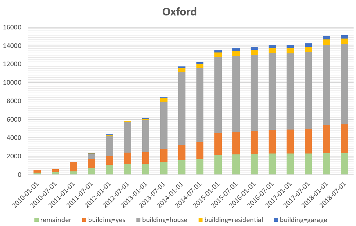
How to become ohsome part 1: Visualizing the historical evolution of OSM buildings of your city
This blog post is the start of a series of posts, which describe what you are able to do using the ohsome framework developed at the Heidelberg Institute of Geoinformation Technology (HeiGIT). OpenStreetMap (OSM), the biggest open map of our … Read More
Conceptual compliance analysis with the OSHDB, Part 1
Conceptual compliance measures to what degree contributors of volunteered geographic information (VGI) are using proposed tagging-standards. Here, we look into OpenStreetMap (OSM) as the most well-known example for VGI. In OSM the most important tagging-guideline is defined by its wiki. … Read More
Conceptual compliance analysis with the OpenStreetMap History Database (OSHDB)
Conceptual compliance measures to what degree contributors of volunteered geographic information (VGI) are using proposed tagging-standards. Here, we look into OpenStreetMap (OSM) as the most well-known example for VGI. In OSM the most important tagging guideline is defined by its … Read More
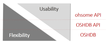
Ohsome – a high level architectural overview of the OSM History Analytics platform
Recently we introduced the ohsome platform for OSM History Analytics. Now we want to give you a high-level overview of the ohsome platform and the components it consists of. Ohsome API The ohsome platform is based on a three-layers API … Read More

The Ohsome API: dynamic OSM statistics for real-world applications
The Ohsome API, developed at HeiGIT, is part of the ohsome OSM history analytics platform (and yes, it is pronounced like the word „awesome“ 😉. It serves as the connection between the OpenStreetMap History Database (OSHDB) and possible frontends, such … Read More
Introducing the ohsome OSM History Analytics Platform
The big spatial data analytics team at HeiGIT is currently developing the ohsome OpenStreetMap history analytics platform. Our aim is to make OSM’s full-history data more easily accessible for various kinds of data analytics tasks on a global scale. OpenStreetMap … Read More