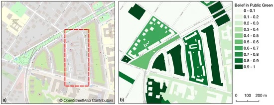
Public urban green spaces are important for the urban quality of life. Still, comprehensive open data sets on urban green spaces are not available for most cities. As open and globally available data sets, the potential of Sentinel-2 satellite imagery … Read More
Deutsch

Projektstart von SocialMedia2Traffic – Ableitung von Verkehrsinformationen aus Social–Media-Daten
Aktuelle Verkehrsinformationen sind die Voraussetzung für Navigations-Lösungen, um die beste Route und Fahrzeit zu bestimmen. Es gibt jedoch keine frei verfügbaren Verkehrsinformationen auf weltweiter- und Bundesebene. „SocialMedia2Traffic nutzt frei verfügbare Daten aus sozialen Medien wie zum Beispiel Twitter-Nachrichten“, sagt Prof. … Read More
Interested in time-dependent routing?
We are delighted to invite you to join a workshop on open-source routing with time-dependent restrictions, see http://giscienceblog.uni-hd.de/2019/04/17/project-tardur-starts-open-source-routing-with-time-dependent-restrictions/. The workshop is taking place on Friday before the State of the Map conference, 20th September 2019 in Heidelberg. It is free … Read More
Project “TARDUR” starts: Open-source routing with time-dependent restrictions
Time-dependent restrictions and temporal road closures are so far not considered in any freely available software for route planning. Heidelberg University and the company GraphHopper aim to address this issue in their joint project “TARDUR – Temporal Access Restrictions for … Read More