Am 23. September 2023 hält Herr Prof. Dr. Alexander Zipf, Scientific and Managing Director bei HeiGIT und Professor für Geoinformatik / GIScience (GIS) an der Universität Heidelberg, einen Vortrag zum Thema “Klimaschutz und humanitäre Hilfe: Unterstützung aus der Geoinformatik”. Staatliche … Read More
Deutsch
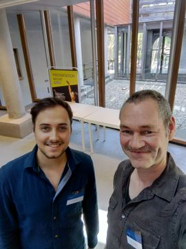
HeiGIT and GIScience at AGILE 2023
Foto: Simon Groß und apl. Prof. Dr. Sven Lautenbach auf der 2023 AGILE Konferenz. Anfang dieses Monats hat die Association of Geographic Information Laboratories in Europe (AGILE) ihre 2023 Konferenz veranstaltet, und Mitglieder des GIScience- und HeiGIT-Teams steuerten Präsentationen, Analysen … Read More

Verstärkte Kooperation zwischen HeiGIT, Deutschem Rotem Kreuz und Deutschem Zentrum für Luft- und Raumfahrt
Titelbild: Teamvertreter von DRK, DRL und HeiGIT in dem Nachbau der europäischen Forschungskapsel COLUMBUS, die einen Teil der internationalen Raumstation (ISS) bildet. Foto: Anne Schneibel, 24.01.2023. Welche Gebäude sind nach einem Erdbeben am schwersten beschädigt? Welche Gegenden haben keinen Zugang … Read More
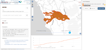
Disaster openrouteservice to support the current response efforts to the Türkiye/Syria earthquake
Am 6. Februar um 4.17 Uhr morgens wurde ein Erdbeben der Magnitude 7.7 im Süden der Türkei aufgezeichnet. Dies ist das stärkste Erdbeben in der Türkei seit Beginn der Aufzeichnungen 1939. Die türkische Regierung löste einen Alarm der Stufe 4 … Read More
HGG Vortrag: Digitale Geographie im Katastrophenmanagement
Einladung Vortrag Online: Dienstag, 14. Dezember 2021, 19:15 Uhr Melanie Eckle-Elze, Benjamin Herfort, Dr. Carolin Klonner Digitale Geographie im Katastrophenmanagement Klimawandel, Bevölkerungswachstum, Verstädterung und weitere zunehmende Landnutzungsveränderungen führen dazu, dass immer mehr Menschen in Risikogebieten leben. Um die vorhandenen Risiken … Read More
2021 Volcanic Eruption in La Palma (Spain) continues – Explore the temporal changes of the Lava Field in OpenStreetMap on ohsomeHeX
On the 19th of September 2021 a volcanic eruption on the Canary Island of La Palma started. Since then the resulting lava field is constantly growing and continues its destructive expansion. According to an article in the spanish newspaper El … Read More
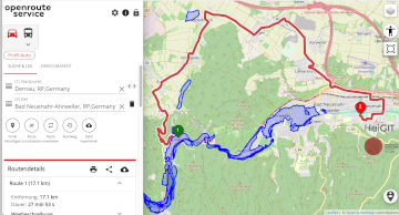
Routenplanung im Überflutungsgebiet: openrouteservice nutzt Copernicus EMS Flut-Daten in spezieller Lösung
Die aktuelle Flut in Deutschland hat zahlreiche Straßen in den betroffenen Gebieten zerstört oder temporär unpassierbar gemacht. HeiGIT arbeitet an freien und offenen, auf Geodaten-basierten Lösungen für die humanitäre Hilfe. Hierzu zählen insbesondere Routenplanung unter Berücksichtigung aktueller Katastrophendaten wie z.B. … Read More

GIScience and HeiGIT contributions to AGILE 2021 conference
The AGILE 2021 conference is taking place this week. It is the the 24rd AGILE conference on GIScience. AGILE is the Association of Geographic Information Laboratories in Europe and the 2021 conference is for the first time held as a … Read More
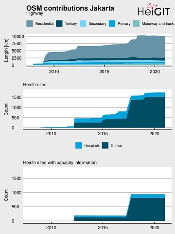
Flood Impact Assessment on Road Network and Healthcare Access at the example of Jakarta, Indonesia
Extreme natural events create catastrophic situations for cities and their populations. Due to climate change and anthropogenic activities, the number and intensity of these events has steadily increased at the global scale. Floods are the most common natural disaster worldwide, … Read More

Einführung in OpenStreetMap und humanitäres Mapping bei der AGIT 2020
HeiGIT unterstützt Workshops zu OpenStreetMap und humanitärem Mapping auf der AGIT 2020 In dieser Woche findet die jährliche AGIT-Konferenz und das parallele GI Forum statt. Während die Konferenz bereits seit mehr als 30 Jahren erfolgreich Vertreter aus Wissenschaft, angewandter Forschung … Read More
Disaster monitoring with Openrouteservice, example from UN Pulse Lab Jarkarta
Recently the UN Pulse Lab Jakarta has developed a disaster monitoring WebApp called the MIND/DisasterMon platform. According to UN Pulse Lab the objective of the MIND/DisasterMon platform is to try to answer questions related to Disaster Monitoring and emergency response … Read More
NASA uses Openrouteservice for study on disaster response times
According to a recent post by NASA, researchers at NASA’s Goddard Space Flight Center in Greenbelt, Maryland, calculated the time that could have been saved if ambulance drivers and other emergency responders had near-real-time information about flooded roads, using the … Read More
Tools for Disaster Risk Reduction by HeiGIT – Celebrating the International Day for Disaster Risk Reduction
Today we celebrate the International Day for #DisasterRiskReduction. HeiGIT offers a growing set of tools and services that support humanitarian aid during and before disasters. Examples include work in the context of the Missing Maps initiative, like conceptualising and extending … Read More

New ORS Jupyter example about Fleet Scheduling for Disaster Response with ORS and VROOM
Routing optimization in a humanitarian context Routing optimization generally solves the Vehicle Routing Problem (a simple example being the more widely known Traveling Salesman Problem). A more complex example would be the distribution of goods by a fleet of … Read More
GIScience / HeiGIT at ICT for Development, Kampala – Usage and Analyses of OpenStreetMap for Development
The 11th Information Communications Technology for Development (ICT4D) Conference brings together hundreds of public, private and civil society organizations, eager to share practical insights on applying digital technology to development, humanitarian, and conservation challenges. Participants share how they are using … Read More

Openrouteservice for Disaster Management: Supporting Humanitarian Logistics with Hourly Updates
The Humanitarian OpenStreetMap Team (HOT) provides immediate support for disaster or humanitarian responses by coordinating and activating a global network of mappers that contribute up-to-date geodata to the OSM database. For example, after the Nepal earthquake 2015 volunteers added up … Read More
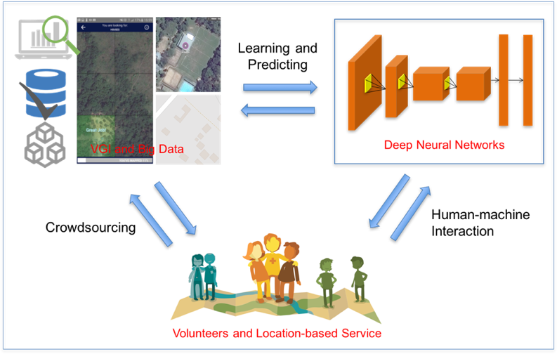
Deep Learning with Satellite Images and Volunteered Geographic Information
Recently, deep learning has been widely applied in pattern recognition with satellite images. Deep learning techniques like Convolutional Neural Network and Deep Belief Network have shown outstanding performance in detecting ground objects like buildings and roads, and the learnt deep … Read More
HeiGIT/GIScience Heidelberg partnership with Humanitarian OpenStreetMap Team (HOT)
We are happy to hereby announce the official partnership of the HeiGIT/GIScience Research Group Heidelberg and the Humanitarian OpenStreetMap Team (HOT)! The GIScience Research Group at Heidelberg University has been supporting the use of OpenStreetMap for humanitarian and disaster management … Read More