Einladung Vortrag Online: Dienstag, 14. Dezember 2021, 19:15 Uhr Melanie Eckle-Elze, Benjamin Herfort, Dr. Carolin Klonner Digitale Geographie im Katastrophenmanagement Klimawandel, Bevölkerungswachstum, Verstädterung und weitere zunehmende Landnutzungsveränderungen führen dazu, dass immer mehr Menschen in Risikogebieten leben. Um die vorhandenen Risiken … Read More
Deutsch
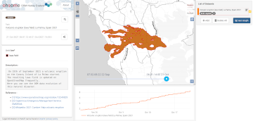
2021 Volcanic Eruption in La Palma (Spain) continues – Explore the temporal changes of the Lava Field in OpenStreetMap on ohsomeHeX
On the 19th of September 2021 a volcanic eruption on the Canary Island of La Palma started. Since then the resulting lava field is constantly growing and continues its destructive expansion. According to an article in the spanish newspaper El … Read More
MapAction and HeiGIT partner to further geoinformation innovation
The Heidelberg Institute for Geoinformation Technology (HeiGIT) and the international humanitarian geospatial charity MapAction have signed a Memorandum of Understanding (MoU) outlining their plans to collaborate in a number of areas. Both organisations share a common vision to support humanitarian … Read More
Mapathons im Rahmen der OSM Geography Awareness Week – OSM GeoWeek
Kooperation ist in der Humanitären Hilfe oft der Schlüssel, um Menschen in Not schnell und effizient helfen zu können. Das gilt insbesondere beim Austausch von Informationen und Kartenmaterial. Besonders herausfordernd sind die Situationen für Humanitäre Organisationen in Gebieten, von denen … Read More
CALL FOR PAPERS – GIS Track at 18th International Conference on Information Systems for Crisis Response and Management (ISCRAM 2021)
CALL FOR PAPERS – 18th International Conference on Information Systems for Crisis Response and Management (ISCRAM 2021) May 23-26, 2021, Virginia, USA – https://www.drrm.fralinlifesci.vt.edu/iscram2021/ Virginia Tech Track: Geospatial Technologies and Geographic Information Science for Crisis Management (GIS) https://www.drrm.fralinlifesci.vt.edu/iscram2021/files/CFP/ISCRAM2021-Track10-Geospatial_Technologies Deadline for … Read More
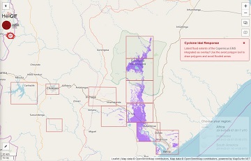
openrouteservice for Disaster Management: Response to Cyclone Idai
The Humanitarian OpenStreetMap Team (HOT) has launched an activation to support humanitarian operations responding to the impact of Cyclone Idai. These efforts were already supported by more than 1500 mappers of the global OpenStreetMap (OSM) community that contribute geodata about … Read More
HeiGIT is starting to move into Mathematikon
Recently the first few members of the Navigation Intelligence and Location Based Services group of the Heidelberg Institute for Geoinformation Technology (HeiGIT) – which is currently being established based on core funding from the Klaus-Tschira Foundation Heidelberg – moved into … Read More