Last week, the annual conference FOSS4G (Free and Open Source Software for Geospatial) has been taken place online. The conference is organized by The Open Source Geospatial Foundation (OSGeo) and attracts over 1000 developers, users, decision-makers and observers from a … Read More
Deutsch
The ohsome quality analyst goes public on Github with new release 0.3.0
The ohsome quality analyst (short: OQT) has been introduced at the beginning of this year and today we are proud to announce two updates. First, we released the new version 0.3.0 which includes new OSM layers and a brand new … Read More
Behind the scenes of the ohsome quality analyst (OQT)
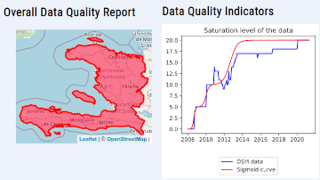
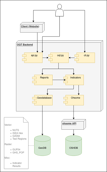
The #ohsome quality analyst (short: OQT) has been online and accessible through its web-interface now for quite some weeks already (see the introductory blog post as a reference). The website is not the only access point to the OQT though. … Read More
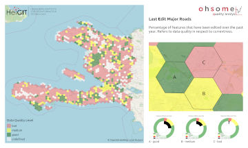
Introducing the Ohsome Quality analysT (OQT)
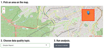
The Ohsome Quality analysT (short OQT) is the name of a new software implemented by HeiGIT that is based on the #ohsome framework. Its main purpose is to compute quality estimations on OpenStreetMap (OSM) data. Any end user such as … Read More
Conceptual compliance analysis with the OSHDB, Part 1
Conceptual compliance measures to what degree contributors of volunteered geographic information (VGI) are using proposed tagging-standards. Here, we look into OpenStreetMap (OSM) as the most well-known example for VGI. In OSM the most important tagging-guideline is defined by its wiki. … Read More
Conceptual compliance analysis with the OpenStreetMap History Database (OSHDB)
Conceptual compliance measures to what degree contributors of volunteered geographic information (VGI) are using proposed tagging-standards. Here, we look into OpenStreetMap (OSM) as the most well-known example for VGI. In OSM the most important tagging guideline is defined by its … Read More