New paper published on healthcare access in Sub-Saharan Africa It is almost a year since SARS-CoV-2 first emerged in China. The virus spread all over the world. Countries south of the Sahara did not receive much attention. Although outbreaks here … Read More
Deutsch
Physische Erreichbarkeiten von Krankenhäusern in Subsahara Afrika – Analyse und Ergebnisse bei COVID-19 Symposium vorgestellt
Vom 06. bis zum 08. Juli fand das Online Symposiums “COVID-19 als Zäsur? Geographische Perspektiven auf Räume, Gesellschaften und Technologien in der Pandemie” statt. Teilnehmer aus Geographie, Medizin, Public health und meidizinischer Geographie diskutierten über drei Tage in sechs verschiedenen … Read More

Exploring OSM for healthcare access analysis in Sub-Saharan Africa
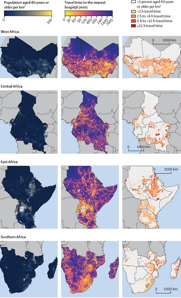
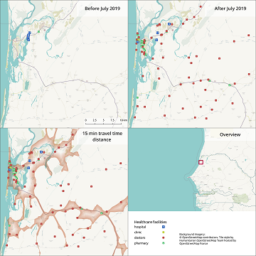
Using hospital locations and the ORS Isochrone service, we have created a method for comparing physical access to healthcare in Sub-Saharan Africa. Hospital locations were derived from OpenStreetMap and compared against another free available dataset. Results indicate strong similarity in … Read More
Colloquium Talk about healthsites.io: Building a baseline of health facility data in OpenStreetMap by M. Herringer
We are happy to invited to the presentation in the GIScience HD colloquium. Everybody interested is invited to join the presentations and the discussion afterwards. Building a baseline of health facility data in OpenStreetMap Markus Herringer, healthsites.io, Amsterdam, NL – … Read More
Healthsites and HeiGIT establish partnership
The Global Healthsites Mapping Project (Healthsites) and the Heidelberg Institute for Geoinformation Technology/ GIScience Research Group are happy to announce the now also formal cooperation. Last week, HeiGIT/ GISciences signed the Healthsites Memorandum of Understanding (MoU) to strengthen their strategic … Read More