Volunteered Geographic Information (VGI) such as OpenStreetMap (OSM) is often defined as the collaborative acquisition of geographic information and local knowledge by volunteers, amateurs or professionals (Goodchild, 2007). The increasing availability and importance of local data in OSM is largely … Read More
Deutsch
New paper published about the OSM Sketch Map Tool
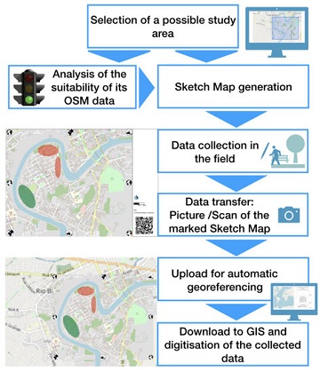
The Sketch Map Tool supports participatory mapping approaches and risk communication. An new paper presents the different functionalities of the tool. OSM data quality can be evaluated regarding the fitness for the sketch-map-approach. Based on the great idea of Field … Read More
GIScience at GeOnG 2020
These days so much is different- also conferences. Carolin Klonner and Marcel Reinmuth attended the GeOnG 2020 virtually. Thanks to the organizers! It worked well and there was great exchange between the participants. The workshop on experiences in defining health … Read More
New paper published: Participatory Mapping and Visualization of Local Knowledge: An Example from Eberbach, Germany
Flooded parking area in Eberbach in January 2019 (Picture: C.Klonner) Worldwide, more and more people are affected by flooding. Local knowledge provides a valuable source of information for disaster risk reduction. We present an approach for visualizing and formalizing this … Read More