MapSwipe has ben announced as ‘App of the Day‘ in the Apple AppStore! (27.08.2021) Thank you to all our volunteers for the continued help and support which keeps the app going. Read the blogpost here: https://apps.apple.com/ca/story/id1559236909 The team at the … Read More
Deutsch
Reminder – starting THIS week: Evaluating Two-part OSM Mapathons on Mai 05 and May 11
The project “25 Mapathons“ goes into the next phase. Based on the experience of until today 17 OSM mapathons with German Red Cross (GRC) chapter and an extensive literature review on the success of mapathons, the “25 Mapathons” team has … Read More
Two-part Mapathons for better new user retention?
The project “25 Mapathons“ goes into the next phase. Based on the experience of until today 17 OSM mapathons with German Red Cross (GRC) chapter and an extensive literature review on the success of mapathons, the “25 Mapathons” team has … Read More
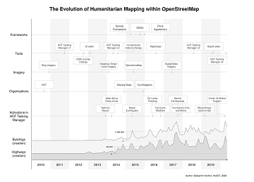
The evolution of humanitarian mapping within the OpenStreetMap community
In the past 10 years, the collaborative maps of OpenStreetMap (OSM) have been used to support humanitarian efforts around the world as well as to fill important data gaps for implementing major development frameworks such as the Sustainable Development Goals … Read More
One step forward for “25 Mapathons” – today Online Mapathon at Humanitarian Congress
The project “25 Mapathons” made an important step forward by successfully completing the first four Mapathons of the project. Two Mapathons were conducted with German Red Cross (GRC) members from the Red Cross Regional association of Westfalen-Lippe. Another two Mapathons … Read More
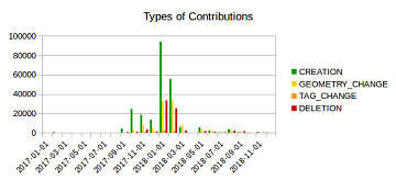
Mapping Rohingya Refugee Camps in Bangladesh – An Analysis Using the OSHDB API
Humanitarian mapping activations show increasing numbers of contribution. This blog post illustrates the specific potential of the OSHDB API [1] for detailed analyses of such activations by means of a case study. The examined area is Cox’s Bazar in Southeast … Read More
5 Years Missing Maps- Achievements and future work and how to visualize the Missing Maps impact using ohsome
Happy Birthday Missing Maps! On the occasion of the recently launched Missing Maps 5 Years Birthday Blog, that also highlighted our latest Missing Maps related HeiGIT and ohsome projects, we put together an overview of our years with and within … Read More
Marcel Reinmuth: Talk about internship at Humanitarian OpenStreetMap Team Uganda
GIScience HD/HeiGIT sind seit geraumer Zeit Partner des Humanitarian Open StreetMap Team (HOT) und arbeiten an gemeinsamen Projekten zur Verbesserung von Geoinformationstechnologien und der Verfügbarkeit von Geodaten (insb. OpenStreetMap) für humanitäre Einsätze, insbesondere im globalen Süden, z.B. über die Missing … Read More
Standortübergreifender Mapathon im Rahmen der Geography Awareness Week
im Rahmen der Geography Awareness Week laden die Geographie-Fachschaften der Standorte Göttingen, Hannover, Würzburg und Heidelberg und die disastermappers heidelberg herzlich zum standortübergreifenden Mapathon ein! An diesem Mapathon werden wir gemeinschaftlich mit Hilfe von OpenStreetMap und fernerkundlichen Methoden neue Kartendaten … Read More
Tools for Disaster Risk Reduction by HeiGIT – Celebrating the International Day for Disaster Risk Reduction
Today we celebrate the International Day for #DisasterRiskReduction. HeiGIT offers a growing set of tools and services that support humanitarian aid during and before disasters. Examples include work in the context of the Missing Maps initiative, like conceptualising and extending … Read More
Disaster Risk Reduction, OpenStreetMap and Missing Maps at Global Platform 2019
Global Platform 2019 in Geneva Creating maps helps humanity. Drawing maps together with communities is crucial for effective risk reduction interventions, ensuring no one is left behind. The progress of the implementation of the targets set by the Sendai … Read More
GIScience / HeiGIT at ICT for Development, Kampala – Usage and Analyses of OpenStreetMap for Development
The 11th Information Communications Technology for Development (ICT4D) Conference brings together hundreds of public, private and civil society organizations, eager to share practical insights on applying digital technology to development, humanitarian, and conservation challenges. Participants share how they are using … Read More
Addressing the challenge of localizing SDGs with openrouteservice
Where is the next health center? What areas show less accessibility to health centers and are therefore the most vulnerable? In 2018, the openrouteservice team already illustrated how these questions related to vulnerability can be addressed with openrouteservice APIs, at … Read More
HeiGIT at German Red Cross “Digitalisation in Civil Protection” congress
HeiGIT members Melanie Eckle and Martin Hilljegerdes were invited to the “Digital in civil protection” congress of the Landesverband Westfalen-Lippe in Münster to share insights and to present current activities all around “Potentials of Open Data and Digital Humanitarians for … Read More

Deep Learning from Multiple Crowds: A Case Study of Humanitarian Mapping
Satellite images are widely applied in humanitarian mapping which labels buildings, roads and so on for humanitarian aid and economic development. However, the labeling now is mostly done by volunteers. In a recently accepted study, we utilize deep learning to … Read More