Im modernen Technologiezeitalter sind mobile Applikationen notwendig um die breite Masse zu erreichen. Deshalb ist es für jede Webanwendung kritisch über mobile Endgeräte erreichbar zu sein. Im Fall von ohsomeHeX muss, um die Nutzung auf mobilen Geräten zu ermöglichen, die … Read More
Deutsch
ohsome Region des Monats: Tags zu den Themengebieten Wandern und Berge
Willkommen zurück zu einem neuen Teil der Blogserie ohsome Region des Monats! Dies wird Teil zwei unserer Posts zu Tags im Zusammenhang mit Wanderungen sein, und dieses Mal werden wir die Verbindung zwischen Benutzeraktivität und diesen Tags untersuchen. Dazu verwenden … Read More
Recent feature additions to Ohsome Quality analysT
Seit der Veröffentlichung des ohsome Quality Analyst (Short OQT) im Februar letzten Jahres haben wir an der Entwicklung eines leicht zugänglichen, aber leistungsstarken Toolkits gearbeitet, das Endbenutzern Einblicke in die Qualität der OpenStreetmap-Daten (OSM) bietet. Ein Überblick über die Funktionalitätserweiterungen, … Read More
ohsome quality analyst (OQT) auf der FOSSGIS Konferenz am 09.03.22
Vom 9. bis zum 12. März 2022 findet die jährliche FOSSGIS Konferenz statt, die führende Konferenz für Freie und Open Source Software für Geoinformationssysteme und Open Data im deutschsprachigen Raum. HeiGIT wird dabei am 09.03. um 16:30–16:50 Bühne 2 ONLINE … Read More
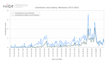
How to become ohsome part 11 – counting contributions
Hello and welcome back to the How to become ohsome-blog series! We hope the new year started off well for you! If you’re new to the series, you should read our other posts in the series, as well as the … Read More
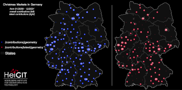
How to become ohsome part 10 – ohsome holiday contributions
Welcome back to our blog post series How to become ohsome, where you get short and simple explanations on how you can become ohsome yourself! This time, it’s all about our new endpoints, which enable you to track which contributions … Read More
United Nations World Data Forum Blog on Healthcare Accessibility Map
In the context of the United Nations World Data Forum 2021 organised by the United Nations Statistics Division and UN member states a series of blogposts has been published by UNSTATS. Among them is one by Alexander Zipf about improving … Read More
HGG Vortrag: Digitale Geographie im Katastrophenmanagement
Einladung Vortrag Online: Dienstag, 14. Dezember 2021, 19:15 Uhr Melanie Eckle-Elze, Benjamin Herfort, Dr. Carolin Klonner Digitale Geographie im Katastrophenmanagement Klimawandel, Bevölkerungswachstum, Verstädterung und weitere zunehmende Landnutzungsveränderungen führen dazu, dass immer mehr Menschen in Risikogebieten leben. Um die vorhandenen Risiken … Read More
HeiGIT and GIScience at Virtual Conference of the Red Cross Red Crescent Urban Collaboration Platform 2021
On Friday, November 26th, Dr. Carolin Klonner (GIScience Research Group) and Melanie Eckle-Elze (HeiGIT) will be supporting the Urban Context Unit of German Red Cross (GRC) in the “Data and Digitalisation in Urban Humanitarian Action” session at the Virtual Conference … Read More
FOSS4G 2021 Videos with HeiGIT contributions online – OSM data quality and MapSwipe
Recently videos with our contributions by HeiGIT to the FOSS4G conference were put online. Did you miss the event? Now you can watch whenever you like 🙂 Benni by HeiGIT explains who to use the ohsome.org framework to develop an … Read More
ohsome Region of the Month – crop tagging
Hello and welcome back to another blog post of the ohsome Region of the Month series where you can learn about potential use cases of the ohsome API. This month we were be looking at the crop tag and tried … Read More
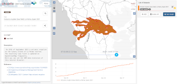
2021 Volcanic Eruption in La Palma (Spain) continues – Explore the temporal changes of the Lava Field in OpenStreetMap on ohsomeHeX
On the 19th of September 2021 a volcanic eruption on the Canary Island of La Palma started. Since then the resulting lava field is constantly growing and continues its destructive expansion. According to an article in the spanish newspaper El … Read More
HeiGIT and MapAction at FOSS4G 2021: Using the ohsome quality analyst to support humanitarian mapping
Last week, the annual conference FOSS4G (Free and Open Source Software for Geospatial) has been taken place online. The conference is organized by The Open Source Geospatial Foundation (OSGeo) and attracts over 1000 developers, users, decision-makers and observers from a … Read More
ohsome Region of the Month – August
Hello and welcome back to the ohsome Region of the Month-blog post series where you can read about potential use cases of the ohsome API and maybe even get inspired to send some requests of your own. If you are … Read More
Analysing the Impact of Large Data Imports in OpenStreetMap
OpenStreetMap (OSM) is a global mapping project which generates free geographical information through a community of volunteers. OSM is used in a variety of applications and for research purposes. However, it is also possible to import external data sets to … Read More
HeiGIT/GIScience @ State of the Map 2021
Like in 2020, this year’s State of the Map (SotM) is taking place online this week from tomorrow 2021-07-09 to 2021-07-11, starting at 12:00 (CEST) each day. This year, HeiGIT is a bronze sponsor. In addition, there are a total … Read More
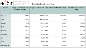
ohsome region of the month: Which country has the longest coastline?
The ohsome region of the month blog post series is back and since it’s summer this time we’re taking you to the coast. Before that happens, if this is your first blog post of this format you might want to … Read More
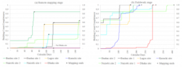
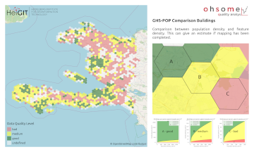
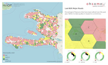
OSM data quality analysis for different stages of the mapping process
Slums are an important operational area for humanitarian organisations: Because of provisional housing, poor sanitation and difficult socio-political circumstances offers of help from such organisations are important and often necessary. For such deployments, humanitarian actors rely heavily on Volunteered Geographic … Read More
Monitoring OSM and Tasking Manager to Map 1 Billion
In 2020, the Humanitarian OpenStreetMap Team (HOT) received funding from seven donors through TED’s Audacious Project. This has accelerated HOT’s ambition to map an area home to one billion people. HOT is working to add places at high risk of … Read More

GIScience and HeiGIT contributions to AGILE 2021 conference
The AGILE 2021 conference is taking place this week. It is the the 24rd AGILE conference on GIScience. AGILE is the Association of Geographic Information Laboratories in Europe and the 2021 conference is for the first time held as a … Read More