A new month – a new post of the how to become #ohsome blog series. Welcome to part 7, in which we will show you 7 different ways how you can send a request to the ohsome API using different … Read More
Deutsch

New function in the ohsome API for checking query parameters
As you may already know from the latest blog posts, new advancements are brought with the release 1.0 of the #ohsome API. One minor function involves the correctness of parameters that you can use in your queries, which was developed … Read More

How to become ohsome part 6: Introducing the magical filter parameter
We are back again with a fresh part of the How to become ohsome blog series. In case this 6th part of the series is your first one, or you have not heard from our awesome OpenStreetMap History Data Analytics … Read More

ohsome API 1.0 is here
As we’ve announced it in a previous post, the Open Source release 1.0 of the ohsome API has finally arrived. As a reminder, or for those of you that hear “ohsome” for the first time, the aim of the ohsome … Read More
Announcing release 1.0 of ohsome API
Big news from the ohsome team: the release 1.0 of one of our major services, the ohsome API for ohsome OpenStreetMap History Analytics, is on the doorstep. We are bringing three major advancements along with this version. The first one … Read More
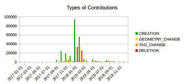
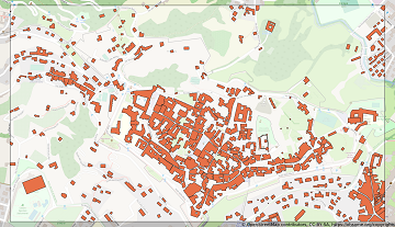
Mapping Rohingya Refugee Camps in Bangladesh – An Analysis Using the OSHDB API
Humanitarian mapping activations show increasing numbers of contribution. This blog post illustrates the specific potential of the OSHDB API [1] for detailed analyses of such activations by means of a case study. The examined area is Cox’s Bazar in Southeast … Read More
Becoming ohsome is simple: Adding support of simple feature types to the ohsome API
It’s been a while, since we have published the last blog post about the awesome ohsome platform, but don’t worry, there’s always something happening of course in the spatial analytics team of HeiGIT. So here we are, back on track … Read More
HeiGIT presents ohsome Lab at FOSS4G 2019 Bucharest
This week, the annual conference FOSS4G (Free and Open Source Software for Geospatial) is taking place in Bucharest, Romania. The conference is organized by The Open Source Geospatial Foundation (OSGeo) and attracts over 1000 professionals from industry and academia each … Read More
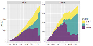
Exploring OSM history: the example of health related amenities
Introduction Exploring how OpenStreetMap data developed over time across different administrative units might reveal interesting insights into the self organizing approach of the OSM communities and can potentially be used to derive intrinsic data quality indicators. It might even be … Read More
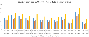
How to become ohsome part 5: Measuring numbers of users editing different OSM features
Besides dealing with a snake, making quality assessments, or generating comparable statistics, one needs to know how to handle the whole functionality provided by the ohsome API to really become ohsome. And to achieve exactly that, this blog presents the … Read More
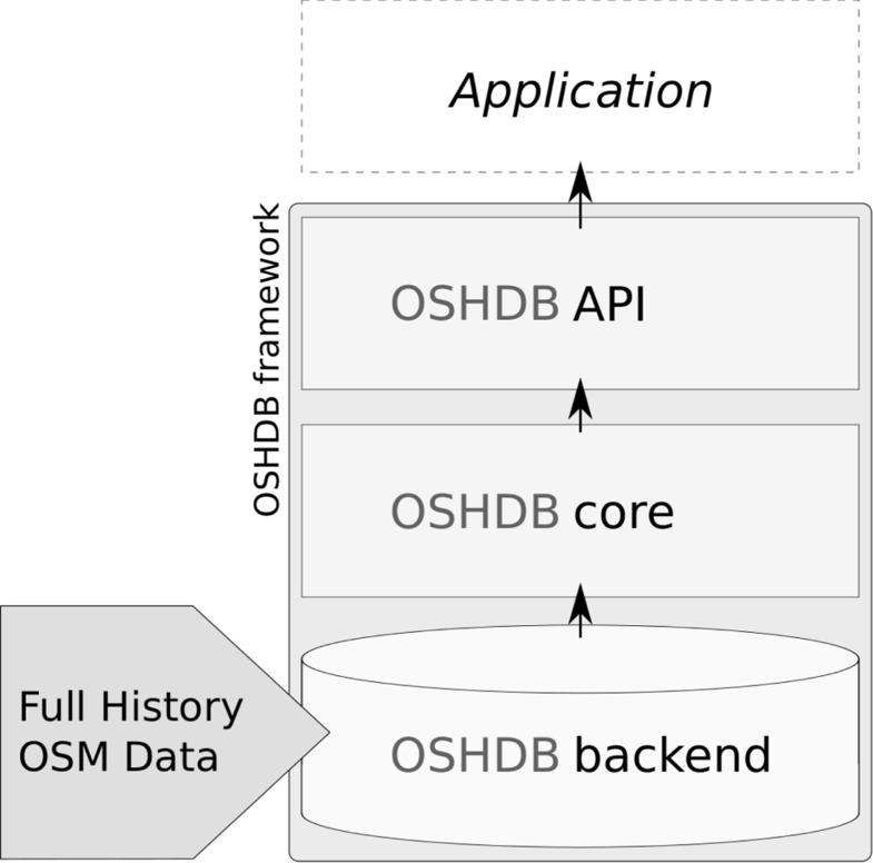
OSHDB: a framework for spatio-temporal analysis of OpenStreetMap history data
Earlier we published several blogposts introducing the ohsome platform and its parts (e.g. the ohsome API for example, which was often showcased here in the blog) and its backbone the OSHDB (very recently version 0.5 was published). A recent open … Read More
OpenStreetMap History Database – version 0.5
The OpenStreetMap History Database (OSHDB) is what powers most of the functionality of HeiGIT’s ohsome platform. The ohsome API for example, which was often showcased here in the blog, is built on top of the OSHDB. Just recently, an open … Read More
How to become ohsome part 4: handling a snake in a notebook on another planet
Welcome back to a new episode of how to become ohsome. Yes, you’ve read the heading correctly. We are really talking about a snake in a notebook on another planet. If you are familiar with one of the most used … Read More
Global analyses are ohsome
We, the Big Spatial Data Analytics Group at HeiGIT have ohsome news to share: From now on, you can send your requests to our global ohsome API instance. So far, we’ve had a public instance for Nepal and Germany, but … Read More
OpenStreetMap history explorer – ohsomeHeX published
The exploration of the history of OpenStreetMap data presents an important step to uncover semantic connections, regions of interest and their contiguity in time and space at varying scales. Therefore, the HeiGIT Big Spatial Data Analytics team presents a first … Read More
How to become ohsome part 3: Identifying different mapping schemes
This is your first blog of the ohsome series? Before you might be confronted with any potential spoilers, you should better check out the first and the second part of this blog series (or the intro to the idea and … Read More
HeiGIT at German Red Cross “Digitalisation in Civil Protection” congress
HeiGIT members Melanie Eckle and Martin Hilljegerdes were invited to the “Digital in civil protection” congress of the Landesverband Westfalen-Lippe in Münster to share insights and to present current activities all around “Potentials of Open Data and Digital Humanitarians for … Read More
How to become ohsome part 2: Comparing different regions based on their attributive completeness of OSM data
Welcome back to the second part of the blog series how to become ohsome. If you have not read the first part yet, better go and check it out now. It explains how you can create an ohsome visualization of … Read More
How to become ohsome part 1: Visualizing the historical evolution of OSM buildings of your city
This blog post is the start of a series of posts, which describe what you are able to do using the ohsome framework developed at the Heidelberg Institute of Geoinformation Technology (HeiGIT). OpenStreetMap (OSM), the biggest open map of our … Read More
Conceptual compliance analysis with the OSHDB, Part 1
Conceptual compliance measures to what degree contributors of volunteered geographic information (VGI) are using proposed tagging-standards. Here, we look into OpenStreetMap (OSM) as the most well-known example for VGI. In OSM the most important tagging-guideline is defined by its wiki. … Read More