Seit kurzem nutzt die Stadt Mannheim openrouteservice (ORS) von HeiGIT für das Routing von Fußgängern, Fahrräder, Autos, LKW und Rollstuhlfahrern im Online-Stadtplan für die breite Öffentlichkeit, d.h. die Bürger und Besucher von Mannheim. Sie können es hier verwenden: https://www.gis-mannheim.de/mannheim/index.php?bl=wms_web_grau&service=mannheim<=mod_ors Dies … Read More
Deutsch
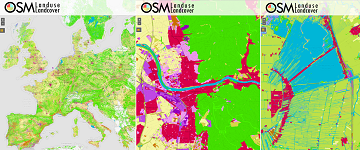
Contiguous high resolution OSMlanduse map of the European Union by combining Copernicus data and OpenStreetMap
Find here a new update of the OSMlanduse.org map. By injecting known tags provided by OpenStreetMap (OSM) into a remote sensing feature space using deep learning, tags were predicted when absent thus creating a contiguous map – initially for the … Read More
GeoNet.MRN at Smart City Expo World Congress Barcelona 2019
Last week was the Smart City Expo World Congress 2019 took place in Barcelona. Our region geoinformation network GeoNet.MRN was there with a booth presenting the members of GeoNet.MRN, among others the GIScience Research Group / HeiGIT at Heidelberg University. … Read More

HeiGIT and Humanitarian OpenStreetMap Team at the Geospatial World Forum 2019 in Amsterdam
Beginning of April, Amsterdam will become the gathering place for the global geospatial community. The Geospatial World Forum is organized for the 11th time and builds on previous successes that made it a leading event in sense of innovation, thematic … Read More