
While 2021 hasn’t been an easy year, we still managed to accomplish a lot! Thank you for your continued support, your contributions, and your interest in our work. The team at HeiGIT wishes you and your friends and family a … Read More
English

OpenRouteService for disaster management instance for the Philippines after Typhoon Rai
Just a couple of days ago, on December 16th, large area of the Philippines were hit by Typhoon Rai (local name Odette). The typhoon not only caused vast destruction but also hit many of the communities that already suffered most … Read More
United Nations World Data Forum Blog on Healthcare Accessibility Map
In the context of the United Nations World Data Forum 2021 organised by the United Nations Statistics Division and UN member states a series of blogposts has been published by UNSTATS. Among them is one by Alexander Zipf about improving … Read More
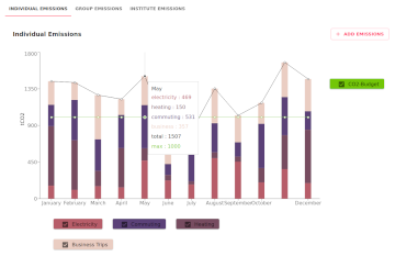
Towards climate neutral science: the Pledge4Future CO2e emission calculator
Under pressure from the decision of the Federal Constitutional Court in spring 2021, the German government has amended its climate targets. The new coalition also wants to stick to these and pursue the goal of greenhouse gas neutrality by 2045. … Read More
HGG Vortrag: Digitale Geographie im Katastrophenmanagement
Einladung Vortrag Online: Dienstag, 14. Dezember 2021, 19:15 Uhr Melanie Eckle-Elze, Benjamin Herfort, Dr. Carolin Klonner Digitale Geographie im Katastrophenmanagement Klimawandel, Bevölkerungswachstum, Verstädterung und weitere zunehmende Landnutzungsveränderungen führen dazu, dass immer mehr Menschen in Risikogebieten leben. Um die vorhandenen Risiken … Read More
HeiGIT and GIScience at Virtual Conference of the Red Cross Red Crescent Urban Collaboration Platform 2021
On Friday, November 26th, Dr. Carolin Klonner (GIScience Research Group) and Melanie Eckle-Elze (HeiGIT) will be supporting the Urban Context Unit of German Red Cross (GRC) in the “Data and Digitalisation in Urban Humanitarian Action” session at the Virtual Conference … Read More
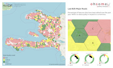
How to become ohsome part 9 – More ways to access the ohsome API
At long last, welcome back to a new blog post of the “How to become ohsome“-series. As it’s been quite a while since you got an introduction to how to access the ohsome API, we would like to pick up … Read More

SocialMedia2Traffic bei Fachaustausch Geoinformation “Smarte Region Rhein-Neckar”
Diesen Donnerstag, 25.11.2021, werden wir unser Kooperationsprojekt SocialMedia2Traffic beim Fachaustausch Geoinformation zum Thema “Smarte Region Rhein-Neckar” vorstellen. Aktuelle Verkehrsinformationen sind eine Voraussetzung für Navigationslösungen, um die beste Route und genaue Reisezeiten zu ermitteln. Diese sind momentan jedoch nicht offen verfügbar. … Read More

HeiGIT participation at HOT Summit 2021
Also this year HeiGIT is participating at the HOT summit with the topic of “The Evolution of Local Humanitarian Open Mapping Ecosystems: Understanding Community, Collaboration, and Contribution”. Again the conference will be virtual and is organized in three blocks across … Read More
Stellenangebot vom DRK Generalsekretariat Berlin zur Unterstützung der HeiGIT Kooperation
Sie haben Erfahrung in den Bereichen Geoinformatik und Open Data und würden gerne dazu beitragen, dass Menschen in Deutschland und weltweit Hilfe erhalten? Sie würden gerne als Teil des größten humanitären Netzwerks der Welt helfen, dessen zukünftige Ausrichtung in diesen … Read More
FOSS4G 2021 Videos with HeiGIT contributions online – OSM data quality and MapSwipe
Recently videos with our contributions by HeiGIT to the FOSS4G conference were put online. Did you miss the event? Now you can watch whenever you like 🙂 Benni by HeiGIT explains who to use the ohsome.org framework to develop an … Read More

Global Health Academy 2021: workshop material online
Last week, the Global Health Academy 2021 took place in an online format with a focus on the COVID-19 pandemics. The conference was conveyed by the Heidelberg Institute of Global Health (HIGH) and aimed at practitioners, researchers and PhD students … Read More
ohsome Region of the Month – crop tagging
Hello and welcome back to another blog post of the ohsome Region of the Month series where you can learn about potential use cases of the ohsome API. This month we were be looking at the crop tag and tried … Read More
meinGrün, Tradur und SocialMedia2Traffic bei der mFUND Konferenz 2021
Letzte Woche konnten wir bei der digitalen mFUND Konferenz drei unserer Projekte einem interessierten Publikum vorstellen. Im Fachforum “Die „15-Minuten-Stadt“ datenbasiert ermöglichen” haben wir gezeigt, wie die meinGrün App, das meinGrün Webportal und die angegliederten Dienste Städte dabei unterstützen könnten, … Read More

WENN ES IN DER STADT ZU HEISS WIRD
Aktuelle Meldung der Universität Heidelberg zum Projekt HEAL: https://www.uni-heidelberg.de/de/newsroom/wenn-es-in-der-stadt-zu-heiss-wird BADEN-WÜRTTEMBERG STIFTUNG FÖRDERT HEIDELBERGER PROJEKT ZU ROUTINGDIENST MIT HITZEVERMEIDENDEN WEGSTRECKEN Wo in der Stadt Heidelberg ist es besonders heiß und wie wirken sich lokale Hitzebelastungen auf gefährdete Personengruppen aus? Mit dieser … Read More
2021 Volcanic Eruption in La Palma (Spain) continues – Explore the temporal changes of the Lava Field in OpenStreetMap on ohsomeHeX
On the 19th of September 2021 a volcanic eruption on the Canary Island of La Palma started. Since then the resulting lava field is constantly growing and continues its destructive expansion. According to an article in the spanish newspaper El … Read More
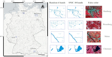
Automatic mapping of national surface water with OpenStreetMap and Sentinel-2 MSI data using deep learning
Large-scale mapping activities can benefit from the vastly increasing availability of earth observation (EO) data, especially when combined with volunteered geographical information (VGI) using machine learning (ML). High-resolution maps of inland surface water bodies are important for water supply and … Read More
Successful end of the 25 Mapathon Project
On October 12th the “25 Mapathon project” was finalized with an exceptionally successful public online mapathon. Around 20 participants with various professional backgrounds mapped 2273 buildings in three hours to support a flood preparedness project of the GRC in Togo. … Read More
HeiGIT and MapAction at FOSS4G 2021: Using the ohsome quality analyst to support humanitarian mapping
Last week, the annual conference FOSS4G (Free and Open Source Software for Geospatial) has been taken place online. The conference is organized by The Open Source Geospatial Foundation (OSGeo) and attracts over 1000 developers, users, decision-makers and observers from a … Read More
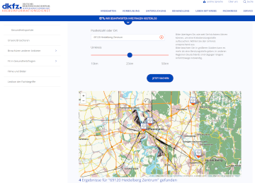
HeiGIT Maps support DKFZ’s Cancer Information Service
One of HeiGIT’s goals is the beneficial use of geoinformation for society. To this end we provide a range of different Web services, mostly based on OpenStreetMap (OSM), such as openrouteservice or the OSM history analytics platform ohsome.org. In particular … Read More