In scope of the disastermappers heidelberg mapathon series “Open Data & the Sustainable Development Goals”, the next virtual OpenStreetMap mapping event “Mapping Human Rights” will take place on Tuesday, June 30th from 6 pm, in cooperation with Amnesty International Heidelberg. … Read More
English
Quota for Openrouteservice multi vehicle optimization increased to support logistics during Corona crisis
Supplying medicine and food is critical not only in disasters. Due to increased global demand due to COVIDー19 HeiGIT increased the API quota for the Openrouteservice multi vehicle route optimization endpoint! Now you can send up to 500 requests per … Read More

Map of COVID-19 Research shows Clinical Trials related to Corona-virus
Many informative maps are available to follow the spread of COVID-19. This is important information but only part of the story. The global scientific and medical communities have immediately responded to the outbreak with focused research activities. This has led … Read More
25 Jahre Klaus Tschira Stiftung: KTS fördert zum Jubiläum zahlreiche 25er Aktionen – HeiGIT mit 25 Mapathons dabei
25 Jahre Klaus Tschira Stiftung: KTS fördert zum Jubiläum zahlreiche 25er Aktionen – HeiGIT mit 25 Mapathons dabei In diesem Jahr wird die Klaus Tschira Stiftung (KTS) 25 Jahre alt. Zu ihrem Jubiläum hat sich die Stiftung eine ganze Reihe … Read More

MapSwipe wins Global Mobile Award for the Best Mobile Innovation Supporting Emergency or Humanitarian Situations
This week, at the prestigious GSMA MWC series (formally known as Mobile World Congress) MapSwipe was awarded the top prize in the Global Mobile Awards’ category for the Best Mobile Innovation Supporting Emergency or Humanitarian Situations. The award recognizes how … Read More
Colloquium Talk about healthsites.io: Building a baseline of health facility data in OpenStreetMap by M. Herringer
We are happy to invited to the presentation in the GIScience HD colloquium. Everybody interested is invited to join the presentations and the discussion afterwards. Building a baseline of health facility data in OpenStreetMap Markus Herringer, healthsites.io, Amsterdam, NL – … Read More
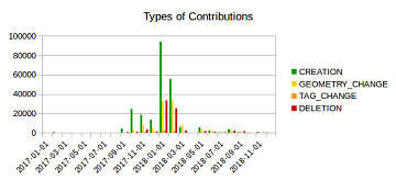
Mapping Rohingya Refugee Camps in Bangladesh – An Analysis Using the OSHDB API
Humanitarian mapping activations show increasing numbers of contribution. This blog post illustrates the specific potential of the OSHDB API [1] for detailed analyses of such activations by means of a case study. The examined area is Cox’s Bazar in Southeast … Read More
Marcel Reinmuth: Talk about internship at Humanitarian OpenStreetMap Team Uganda
GIScience HD/HeiGIT sind seit geraumer Zeit Partner des Humanitarian Open StreetMap Team (HOT) und arbeiten an gemeinsamen Projekten zur Verbesserung von Geoinformationstechnologien und der Verfügbarkeit von Geodaten (insb. OpenStreetMap) für humanitäre Einsätze, insbesondere im globalen Süden, z.B. über die Missing … Read More
Tools for Disaster Risk Reduction by HeiGIT – Celebrating the International Day for Disaster Risk Reduction
Today we celebrate the International Day for #DisasterRiskReduction. HeiGIT offers a growing set of tools and services that support humanitarian aid during and before disasters. Examples include work in the context of the Missing Maps initiative, like conceptualising and extending … Read More
HeiGIT beim Tag der offenen Tür im Auswärtigem Amt, 17.-18. August
Wer steckt eigentlich hinter Missing Maps? Und wie können auch Sie in dem humanitären Mappingprojekt aktiv werden? Besuchen Sie uns heute beim Tag der offenen Tür im Auswärtigem Amt an unserem gemeinsamen Stand mit dem Deutschen Roten Kreuz. Weitere Informationen … Read More
HeiGIT beim Tag der offenen Tür beim Auswärtigen Amt
Am 16. und 17. August öffnet das Auswärtige Amt in Berlin die Tore für die Öffentlichkeit. An diesen Tagen kann nicht nur das Auswärtige Amt selbst besichtigt werden, verschiedene Diplomaten, Vertreter verschiedener Ministerien, Einrichtungen und Organisationen werden vor Ort sein, … Read More

New ORS Jupyter example about Fleet Scheduling for Disaster Response with ORS and VROOM
Routing optimization in a humanitarian context Routing optimization generally solves the Vehicle Routing Problem (a simple example being the more widely known Traveling Salesman Problem). A more complex example would be the distribution of goods by a fleet of … Read More

HeiGIT at AGIT conference 2019 in Salzburg- The spatial view
This week, the annual AGIT conference is again organised in Salzburg. The conference has since more than 30 years successfully gathered representatives of academia, applied research and economy to present latest projects, to share ideas and to develop new approaches. … Read More
Open Positions GIS at German Red Cross – Cooperation with HeiGIT
Das Rote Kreuz Generalsekretariat Berlin schreibt aktuell zwei interessante Vollzeitstellen aus (Standort Berlin). Eine davon – als Fachreferent Geoinformatik – ist direkt auf die konkrete Zusammenarbeit mit dem Heidelberg Institute for Geoinformation Technology (HeiGIT gGmbH) an der Universität Heidelberg ausgerichtet. … Read More
GIScience / HeiGIT at ICT for Development, Kampala – Usage and Analyses of OpenStreetMap for Development
The 11th Information Communications Technology for Development (ICT4D) Conference brings together hundreds of public, private and civil society organizations, eager to share practical insights on applying digital technology to development, humanitarian, and conservation challenges. Participants share how they are using … Read More

Put the world’s most vulnerable people on the map with MapSwipe
Humanitarian organizations can’t help people if they can’t find them. This was the simple reason to create MapSwipe back in 2016 and it is still as pressing as in the very beginning. In the last 2,5 years volunteers have contributed … Read More
HeiGIT at German Red Cross “Digitalisation in Civil Protection” congress
HeiGIT members Melanie Eckle and Martin Hilljegerdes were invited to the “Digital in civil protection” congress of the Landesverband Westfalen-Lippe in Münster to share insights and to present current activities all around “Potentials of Open Data and Digital Humanitarians for … Read More

Deep Learning from Multiple Crowds: A Case Study of Humanitarian Mapping
Satellite images are widely applied in humanitarian mapping which labels buildings, roads and so on for humanitarian aid and economic development. However, the labeling now is mostly done by volunteers. In a recently accepted study, we utilize deep learning to … Read More
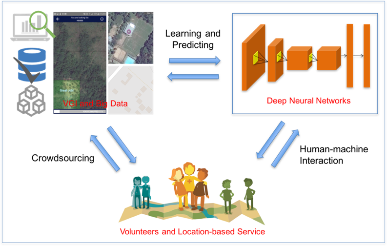
Deep Learning with Satellite Images and Volunteered Geographic Information
Recently, deep learning has been widely applied in pattern recognition with satellite images. Deep learning techniques like Convolutional Neural Network and Deep Belief Network have shown outstanding performance in detecting ground objects like buildings and roads, and the learnt deep … Read More