The Humanitarian OpenStreetMap Team (HOT) , the Heidelberg Institute of Geoinformation Technology (HeiGIT) , and the wider MapSwipe Community started working on an MapSwipe extension to monitor changes in satellite imagery. The goal of the two-month project is to extend … Read More
English
Empower Humanitarian Mapping with Deep Neural Networks to Detect Human Settlements
Recently, earth observation by satellites has shown great capability in supporting a range of challenges such as disaster assessment, agriculture monitoring, and humanitarian mapping. MapSwipe, as a humanitarian mapping app, provides a crowdsourcing platform to collect volunteered geographical information (VGI), … Read More

Put the world’s most vulnerable people on the map with MapSwipe
Humanitarian organizations can’t help people if they can’t find them. This was the simple reason to create MapSwipe back in 2016 and it is still as pressing as in the very beginning. In the last 2,5 years volunteers have contributed … Read More

Deep Learning from Multiple Crowds: A Case Study of Humanitarian Mapping
Satellite images are widely applied in humanitarian mapping which labels buildings, roads and so on for humanitarian aid and economic development. However, the labeling now is mostly done by volunteers. In a recently accepted study, we utilize deep learning to … Read More
HeiGIT/GIScience Heidelberg partnership with Humanitarian OpenStreetMap Team (HOT)
We are happy to hereby announce the official partnership of the HeiGIT/GIScience Research Group Heidelberg and the Humanitarian OpenStreetMap Team (HOT)! The GIScience Research Group at Heidelberg University has been supporting the use of OpenStreetMap for humanitarian and disaster management … Read More
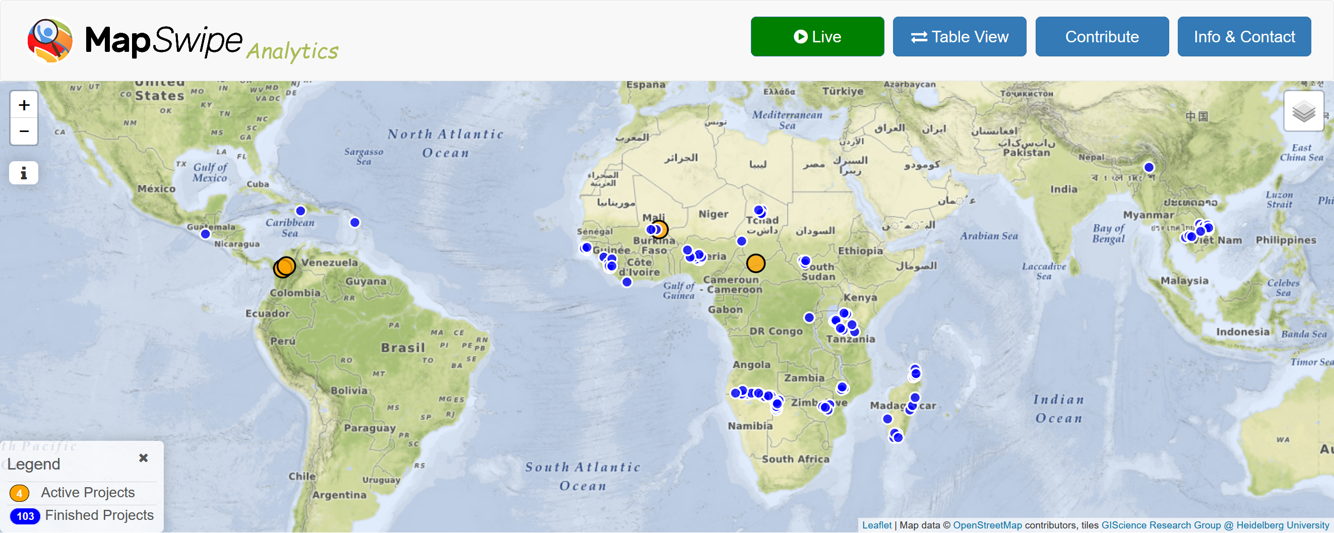
MapSwipe Analytics: Map each Swipe and Tap
Since the launch of the MapSwipe Analytics webpage three month ago we were able to improve our service and offer more detailed information on each project in MapSwipe. MapSwipe is a mobile App for crowdsourcing geographic information needed by humanitarian … Read More