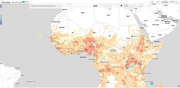
A new map in ohsomeHeX provides an overview of areas in Sub-Sahara Africa where information on health facilities is still missing in OpenStreetMap (OSM). The completeness of OSM is measured by comparing to a reference dataset on public health facilities … Read More
English
Invitation to GIScience colloquium talks related to Humanitarian Aid
We are happy to annouce two higly interesting upcomming presentations in the GIScience colloquium in the next weeks. Everybody interested is invited to join the presentations and the discussion afterwards. The use of geoinformatics at the German Red Cross Katharina … Read More
Healthsites and HeiGIT establish partnership
The Global Healthsites Mapping Project (Healthsites) and the Heidelberg Institute for Geoinformation Technology/ GIScience Research Group are happy to announce the now also formal cooperation. Last week, HeiGIT/ GISciences signed the Healthsites Memorandum of Understanding (MoU) to strengthen their strategic … Read More