This study, published at African Transport Studies, investigates the impact of school sessions on traffic congestion in Nairobi, highlighting how children’s mobility needs are often overlooked in transport planning.
The paper explores how poor integration of school-related travel into urban transport planning contributes to traffic congestion in Nairobi. While the conventional response to congestion has focused on expanding road networks, other crucial aspects—such as public transport, pedestrian safety, and equitable access to education—are frequently neglected. As a result, many residents rely on private vehicles, intensifying congestion, especially during peak travel times.
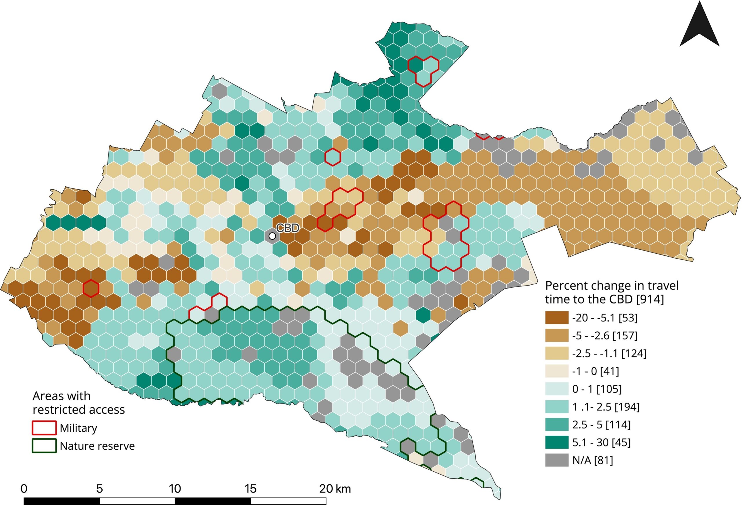
To analyze the specific impact of school sessions on traffic, the researchers used 2019 Uber Movement data, which provides road speed information across Nairobi. They compared traffic conditions during school terms and holiday periods, focusing on changes in mean daily and hourly road speeds across different road types, and modeled travel times to the Central Business District (CBD) from various parts of the city.
Travel time analysis was conducted using openrouteservice, an open-source routing engine that utilizes OpenStreetMap data to model road networks. This tool allowed the researchers to calculate point-to-point travel times and routes, while also incorporating the Uber speed data to simulate realistic driving conditions. The flexibility of openrouteservice in supporting multiple mobility profiles and third-party data integration made it well-suited to capturing Nairobi’s diverse traffic dynamics.
The analysis revealed that road speeds were significantly lower during school terms, with congestion peaking in the morning rush hours (6am–9am). Secondary roads were particularly burdened, and spatial analysis showed that travel time changes were not evenly distributed—some neighborhoods experienced large increases, while others saw decreases. These patterns were especially pronounced in wealthier wards, where families are more likely to drive children to distant, higher-quality schools.
Ultimately, the study highlights how the spatial mismatch between students’ homes and school locations, along with the lack of safe and reliable shared school transport, drives up vehicle volumes during term time. These findings emphasize the need for integrated land-use and transport planning that prioritizes school accessibility, non-motorized mobility, and investment in public and school transport systems to address congestion and promote equitable urban development.
Figure: Percentage Change in travel time to the Central Business Unit (CBD). This map depicts the percentage change in travel time to the CBD for the school term using the travel time of the holiday period as the reference.
Reference: Hatfield, C. R. S., Kustar, A., Reinmuth, M., Cap, C., Beshir, A. A., Klopp, J. M., Zipf, A., Rising, J., & Tun, T. H. (2025). Lessons in traffic: Nairobi’s school term congestion and equity challenges. African Transport Studies, 3, 100044. https://doi.org/10.1016/j.aftran.2025.100044