Join us at Impact Day on May 15th in the foyer of the Neue Universität, organized by the Heidelberg University! The event will showcase the university’s knowledge and technology transfer, spotlighting projects across four focal areas: socially relevant, industrial, sustainable and tangible.
The „Socially Relevant“ island addresses pressing social issues, while the „Industrial“ island highlights collaborations driving technological advancement. The „Sustainable“ island presents projects dedicated to environmental preservation, including ours: „Waterproofing Data – Engaging Stakeholders in Sustainable Flood Risk Governance for Urban Resilience.“ This initiative aims to revolutionize flood-related data management for sustainable, flood-resilient communities.
Our colleagues will guide you through the methodologies and aims of the Waterproofing Data Project (WPD). Additionally, they will showcase the Sketch Map Tool project, which originated from this initiative, demonstrating its practical applications and contributions to participatory mapping.
Funded by the Belmont Forum and NORFACE joint program „Transformations to Sustainability (T2S)“ and the Bundesministerium für Bildung und Forschung, the WPD project has made a significant impact. It has heightened flood awareness in local communities, enhanced OpenStreetMap (OSM) through Mapathons, and fostered collaboration with communities and schools.
Furthermore, the project has developed innovative apps and dashboards to improve data comparability and citizen engagement. Recognized with the ESRC Celebrating Impact Prize in 2023, the success of the WPD project led to the development of the Sketch Map Tool in Heidelberg.
This tool simplifies participatory mapping and has attracted interest from humanitarian organizations like the German Red Cross. Collaboration with such organizations has led to further developments and the recent launch of the new version of the Sketch Map Tool.
We are looking forward to exchange our experience with students and scientists and to learn from each other about effective transfer strategies and the transformative power of collaboration at Impact Day. Don’t miss this opportunity to explore groundbreaking projects and shape the future research!
More information: GIS_Waterproofing; Waterproofing Data
Image source: https://www.uni-heidelberg.de/de/transfer/heiinnovation/impact-day-2024
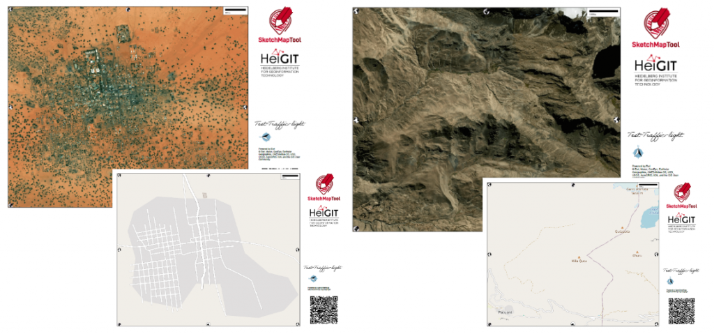
The idea of the Sketch Map Tool is based on experiences from research about flood risk perception including participatory mapping with Field Papers(https://fieldpapers.org/?locale=de) in various case studies (Klonner, Usón, et al. 2021). These studies show the need for the combination of analogue and digital mapping to bridge the gap between involved stakeholders and facilitate data collection and analysis. The Sketch Map Tool prototype combining map creation, quality analysis and georeferencing was developed during the Waterproofing Data Project ((Klonner, Hartmann, et al. 2021), (Porto De Albuquerque 2023), (Klonner et al. in preparation)) and refined through feedback from case studies, for example, in Mozambique (Klonner and Norze 2023). The Sketch Map Tool was developed to provide an easy-to-use and inclusive tool for capturing local knowledge and enabling usage in geoinformation systems.
Klonner, Carolin, Maximilian Hartmann, Rebecca Dischl, Lily Djami, Liana Anderson, Martin Raifer, Fernanda Lima-Silva, Lívia Castro Degrossi, Alexander Zipf, and João Porto De Albuquerque. 2021. ‘The Sketch Map Tool Facilitates the Assessment of OpenStreetMap Data for Participatory Mapping’. ISPRS International Journal of Geo-Information 10 (3): 130. https://doi.org/10.3390/ijgi10030130 .
Klonner, Carolin, and Jeantyl Norze. 2023. ‘Sketch Map Tool’. In Evaluating Participatory Mapping Software, edited by Charla M. Burnett, 149–66. Cham: Springer International Publishing. https://doi.org/10.1007/978-3-031-19594-5_7 .
Klonner, Carolin, Leonie Schuchardt, Maximilian Hartmann, Lima-Silva, Fernanda, Anderson, Liana, Cunha, Maria Alexandra, Mohammed Rizwan Khan, et al. in preparation. ‘Bridging the Gap for Improved Disaster Risk Reduction: How to Combine Authoritative Data and Local Knowledge’.
Klonner, Carolin, Tomás J. Usón, Nicole Aeschbach, and Bernhard Höfle. 2021. ‘Participatory Mapping and Visualization of Local Knowledge: An Example from Eberbach, Germany’. International Journal of Disaster Risk Science 12 (1): 56–71. https://doi.org/10.1007/s13753-020-00312-8 .
Porto De Albuquerque, João. 2023. ‘Waterproofing Data Project: Participatory Flooding Maps for Flood-Prone Neighbourhoods, 2020-2021’. UK Data Service. https://doi.org/10.5255/UKDA-SN-856620 .