OpenStreetMap Data
OpenStreetMap contains a large variety of geographic data, differing widely in scale and feature type. OSM contains everything from single points of interests to whole country borders, from concrete things like buildings up to more abstract concepts such as turn restrictions. This rich temporal dimension makes OSM invaluable for studying how maps evolve, but it also makes the data complex to work with. Because of its size and variety, analyzing OSM history data has always been challenging – there are more than 1.5 billion features mapped in OSM. With the OSHDB, we made this data more accessible to researchers, journalists, community members, and anyone interested in understanding mapping activity and data quality.
From OSHDB to ohsomeDB
The ohsome API, first presented to the OSM community at State of the Map 2018 in Milan, built on this foundation. It enabled users to explore data quality and mapping history across space and time. OSHDB powered these analyses by storing and processing the full OSM history efficiently, making it possible to run anything from local studies to global investigations.
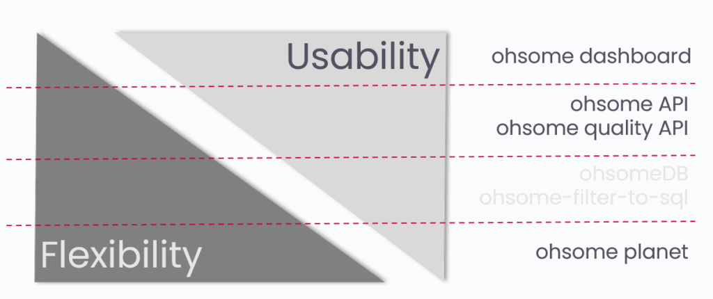
With ohsomeDB, we are rethinking some of the early design decisions inside this technical layer of the ohsome framework. Most users interact with tools such as the ohsome dashboard, the ohsome quality API, the ohsome API, or ohsome-planet, rather than with the database itself. ohsomeDB is the invisible part that allows these services to run faster and at larger scale, balancing flexibility for complex analyses with usability for everyday workflows.
The new system is built on PostgreSQL with PostGIS and uses the Citus extension for partitioning and distributed queries. The database schema is optimized for OSM history data and includes all element versions, geometries, and metadata such as user names, changeset information, time ranges, and country codes. These improvements make analyses of completeness, currentness, and accuracy possible within seconds.
The move to ohsomeDB shifts the focus from processing raw OSM history toward supporting high-performance data quality analyses. This update will strengthen our ongoing work with partners such as Bundesamt für Kartographie und Geodäsie (BKG) and HeiGIT`s Climate Action Team, and it will also benefit researchers and those who rely on consistent, up-to-date OSM statistics and extractions.
Use-cases and applications

Is OpenStreetMap up-to-date?
With ohsomeDB, common questions about OpenStreetMap can be answered more quickly and at larger scale. One example is the question of how up to date OSM is for a given topic or region. By classifying contributions according to topic-specific temporal thresholds, features can be grouped into categories such as up-to-date, in-between, and out-of-date.
How active is the OpenStreetMap community?
Another recurring question concerns the activity of the OSM community. ohsomeDB makes it possible to calculate, for a selected topic, how many distinct mappers contribute over time. Looking at the number of unique contributors per month helps to understand mapping dynamics, assess engagement, and identify regions or themes where activity is increasing or slowing down.
Data extraction
ohsomeDB also supports more specialized analyses, such as extracting information about road surfaces. Paths tagged with certain materials, for example asphalt or paved surfaces, are usually more suitable for cycling, while others, such as cobblestones, can be less comfortable or even unsafe. By classifying ways according to their most common surface tags in OSM, ohsomeDB can help derive thematic maps and indicators that support use cases in mobility, accessibility, and urban planning.
Transition roadmap
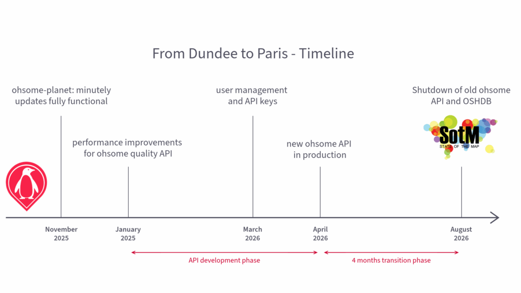
The transition will take place in three stages. We are developing the system together with our core partners, followed by the release of a public prototype for community testing and feedback. In the final phase, users will move from OSHDB to ohsomeDB with moderate support during the transition. The new API will be available from 1 May 2026, and users will have three months to complete the migration.
As part of the modernization, a user account will be required for API access. If you are already using the ohsome API, this change will affect you: when we switch to the new API, existing queries and scripts against the current version will no longer work. The current ohsome API is planned to be shut down after SOTM 2026, and your old queries and scripts will stop working at the latest by August 2026, giving you sufficient time to adapt your workflows.
We’re excited to reach this new milestone in OSM analysis and hope you’ll enjoy exploring what ohsomeDB can do.
Resources and links
ohsome dasboard
ohsome – dashboard
GitHub – GIScience/ohsome-dashboard: Web Client for easy access to OSM History and Quality Analyses
ohsome quality API
GitHub – GIScience/ohsome-quality-api: Data quality estimations for OpenStreetMap
ohsome API
GitHub – GIScience/ohsome-api: API for analysing OpenStreetMap history data