Cities are where climate action has the greatest potential, and where open geospatial data can be used most effectively. Given that by 2050, 70 % of the world’s population will be living in cities, decisions regarding urban infrastructure are among the most powerful levers we have at our disposal. Yet many cities lack the fine-grained, actionable data they need to know where to act first.
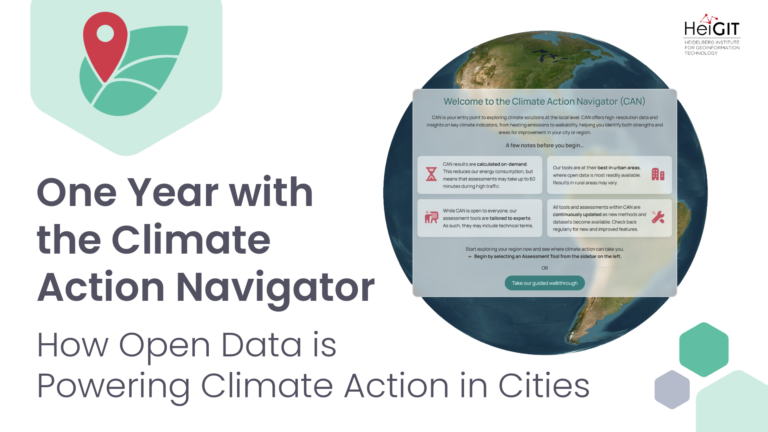
The Climate Action Navigator (CAN) is HeiGIT’s open, interactive dashboard to aid urban climate action. It translates high-resolution geospatial data into clear, neighborhood-level insights, giving cities, NGOs, and local initiatives the information they need to act. From identifying streets where walking infrastructure needs improvement to mapping areas with the highest heating emissions, CAN shows where targeted action will have the greatest impact. The dashboard provides data, maps, and reports at a spatial resolution fine enough to identify specific pain points down to the neighborhood and street level.
The Climate Action Navigator is built to be precise, practical, and useful. Developed in close collaboration with our partners, each tool starts from real use cases and is testing against the specific needs of our users.
Each tool typically combines several indicators to provide a detailed picture of a specific climate action-relevant aspect of an area. At present,the dashboard offers assessment tools for: bikeability, CO₂ budgets, heating emissions, land consumption, land use change, and walkability. New tools will be added in the future.
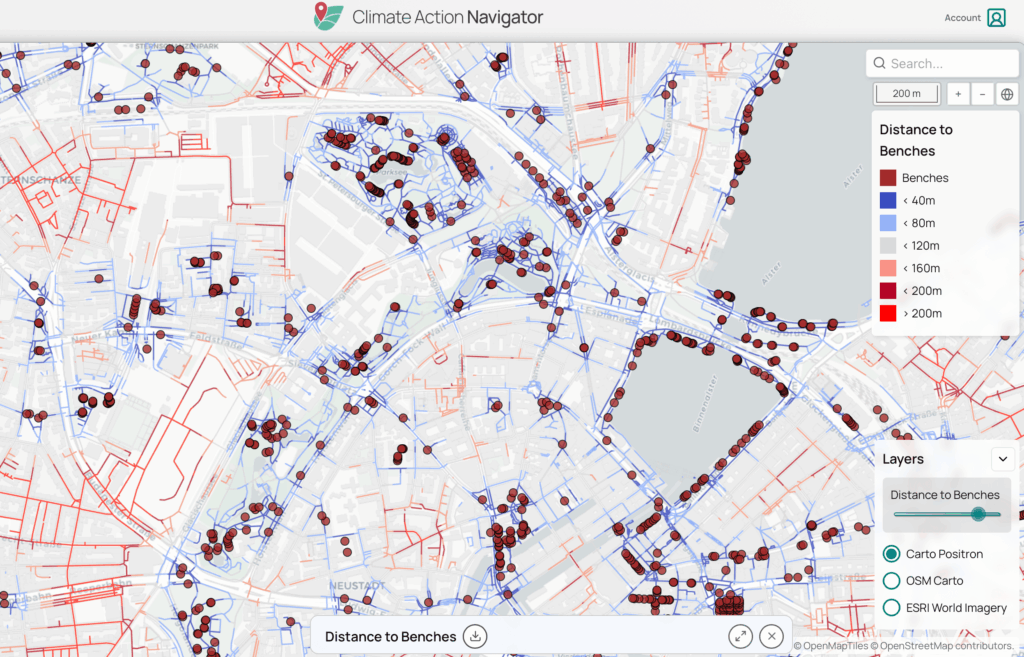
hiWalk assesses the walkability of streets and neighborhoods worldwide, analyzing factors such as surface quality, type and comfort of pedestrian infrastructure, and greenness. Its indicators reveal where urban infrastructure already supports safe, comfortable walking, and where it falls short. Use it to identify where sidewalk improvements or reducing detours would have the most impact.
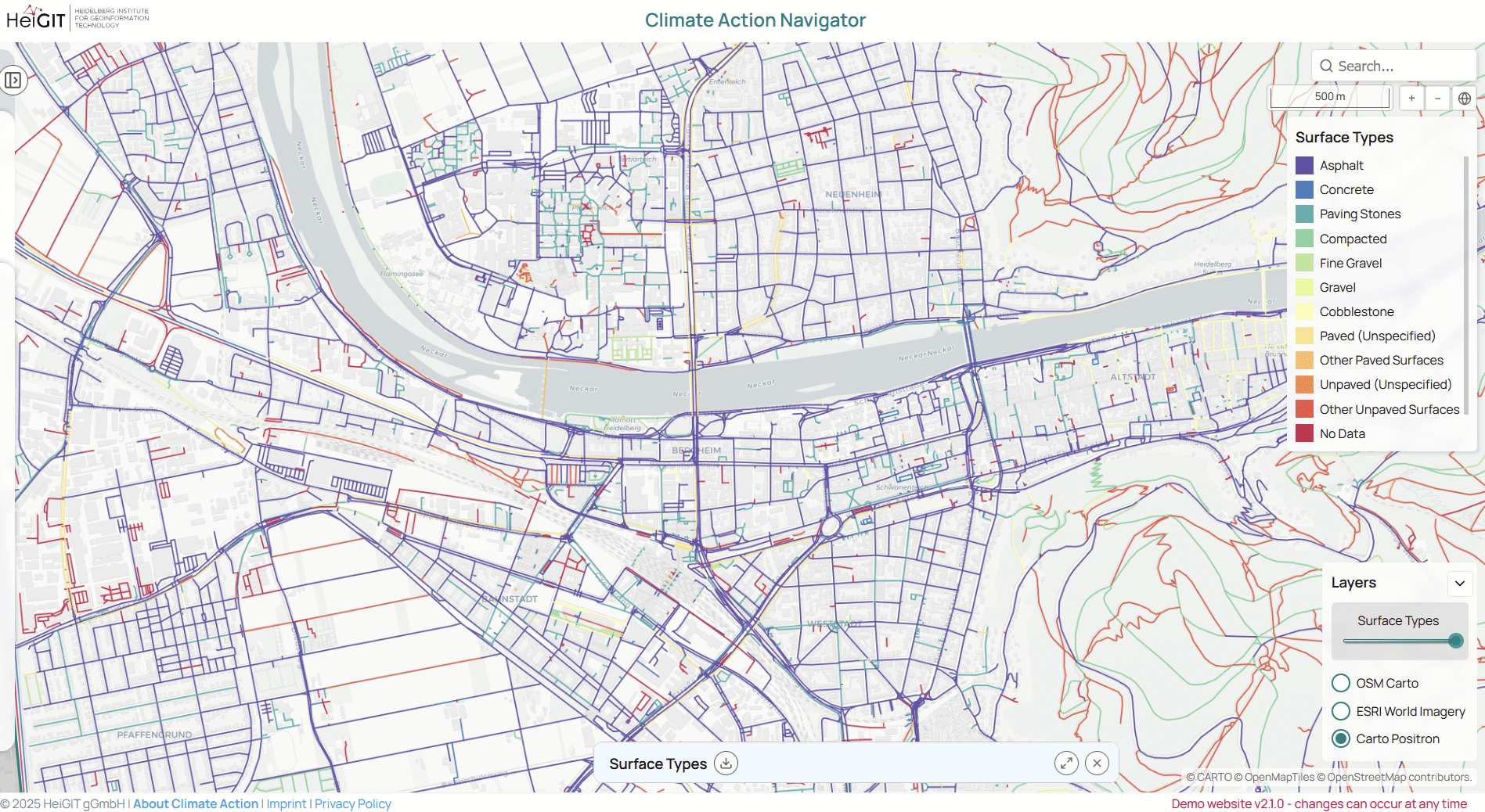
hiBike evaluates cycling infrastructure at a street level, including the presence of dedicated cycling paths, surface quality, and the risk of “dooring”, one of the most common hazards for urban cyclists. It shows both strengths and gaps of the cycling infrastructure, giving planners and advocates a clear map of where improvements of cycling infrastructure are most needed.
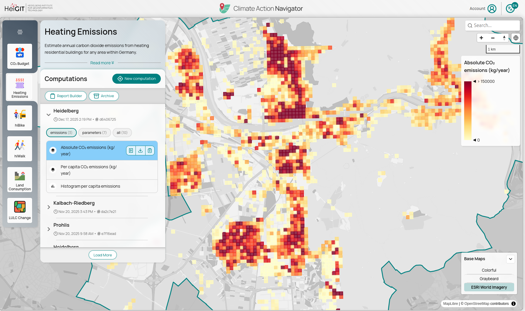
This tool estimates CO₂ emissions from residential heating across Germany at 100-meter resolution, including information on building construction year and energy carrier. It shows not just how much a building emits, but also why; enabling targeted intervention in the neighborhoods where renovation or fuel-switching can have the greatest effect.
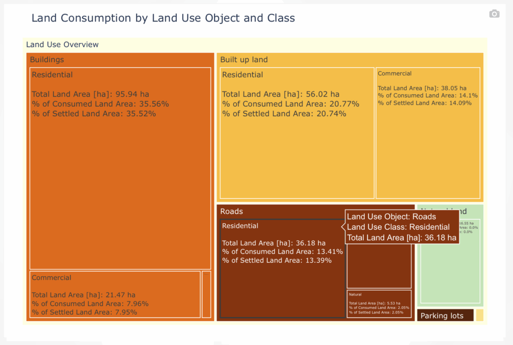
The Land Consumption tool shows how land is being used across a given area, distinguishing various land uses such as buildings, roads, parking, and agriculture. By analyzing land consumption according to land use type, users can identify in which sectors sustainable land-use practices could be improved.
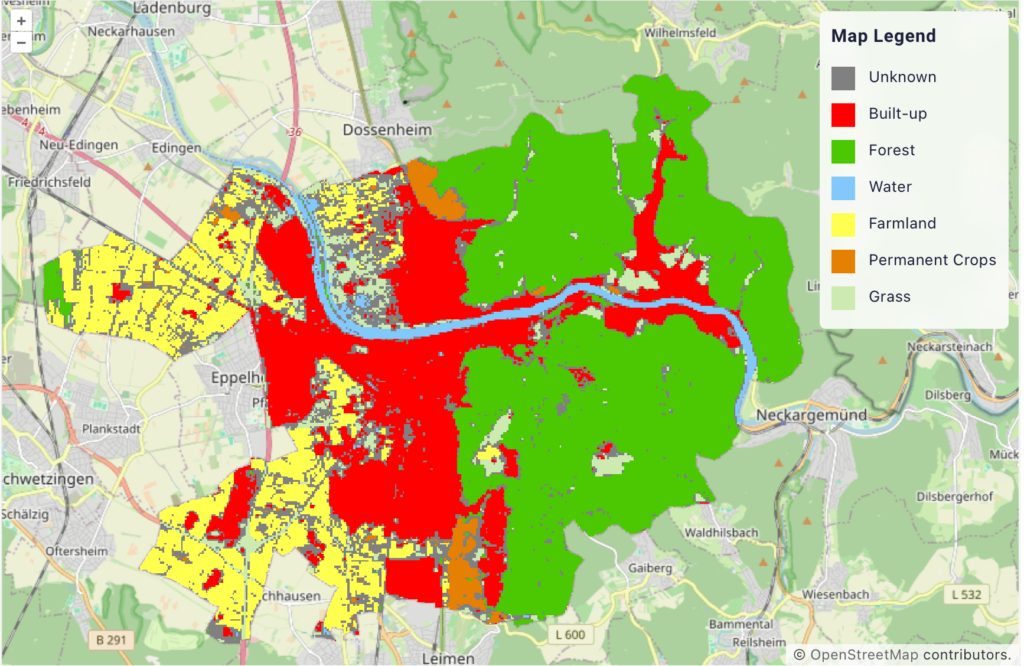
This tool estimates the carbon emissions resulting from land use and land cover changes over a selected time period and area. It provides high-resolution spatial data that links observed land cover changes to their resulting emissions, an important input for land-use policy and conservation planning.
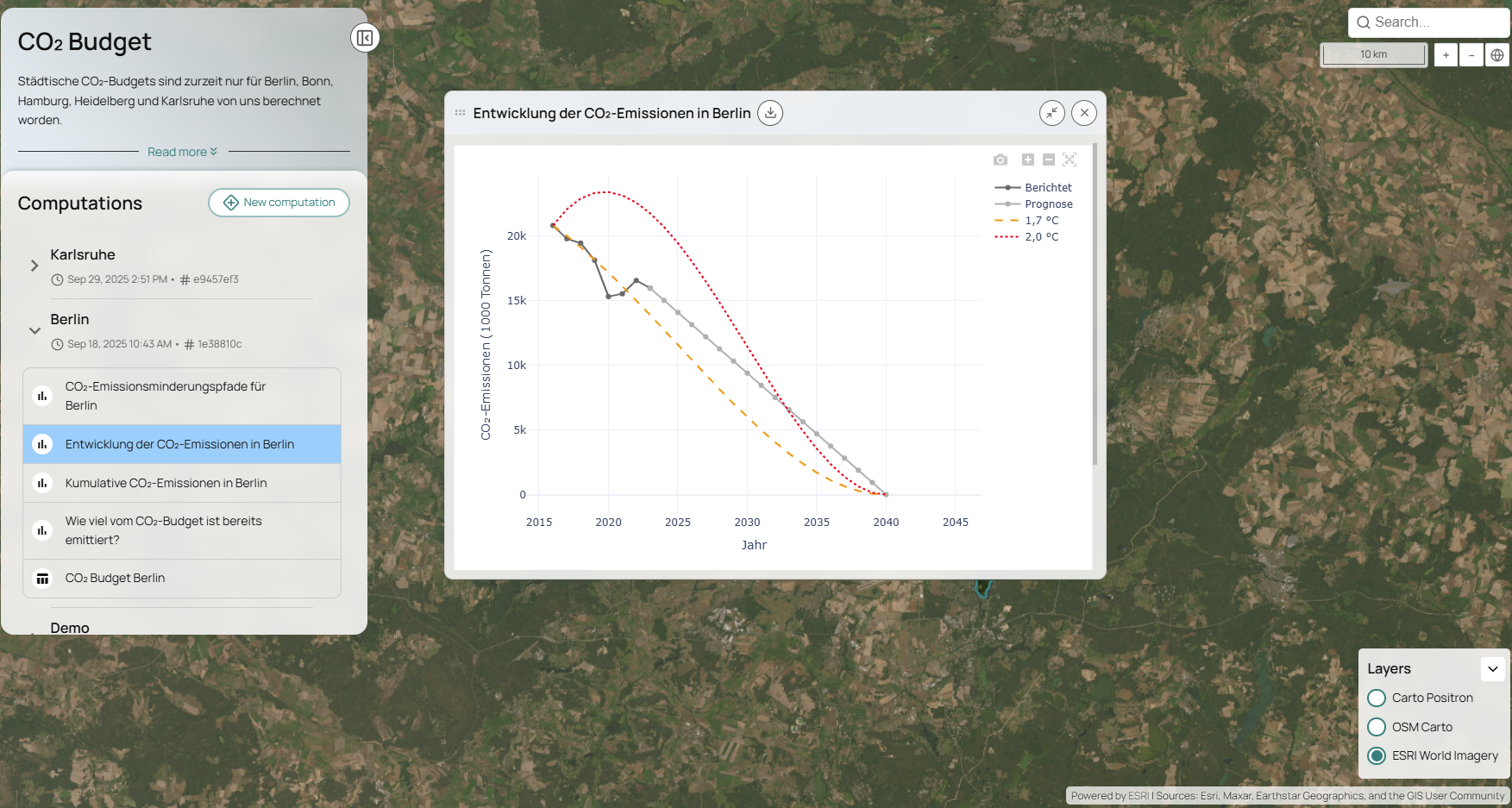
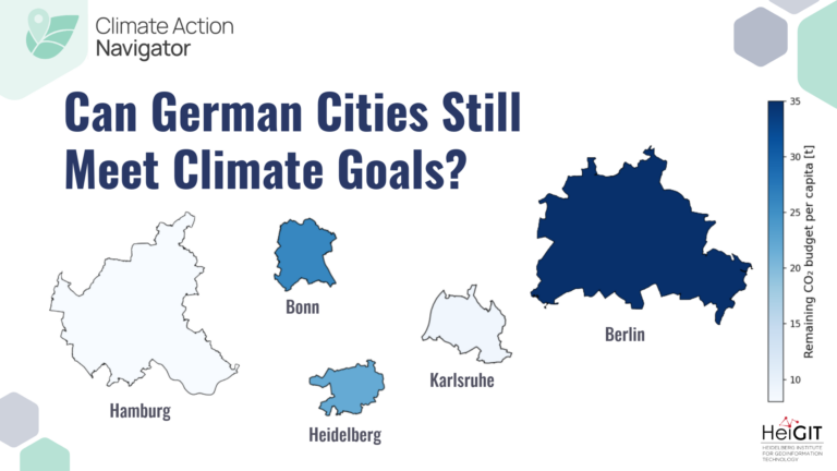
The CO₂ Budget tool shows how much of a city’s carbon budget remains, and whether current emission levels put that budget at risk. Available for selected German cities, it shows where a city stands against its CO₂ budget, and whether it is on track. It makes the commitments of the Paris Agreement visible at the city level.
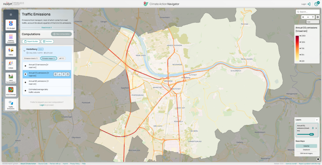
The Traffic Emissions tool maps transport-related CO₂ emissions at street level, providing the resolution needed to identify where reductions matter most. These maps can be used to simulate the impact of specific policy or behavioral changes, such as car-free areas or speed limit reductions.
The Climate Action Navigator is designed for anyone working to understand or improve urban climate action. That is, NGOs, citizen initiatives, researchers, and city administrations are the intended primary user group. But the dashboard is openly accessible to all, as anyone can browse our demos and create a free account explore their city´s climate action efforts and advocate for change.
Our assessment tools rely on official administrative data, satellite imagery, OpenStreetMap (OSM), and more. The frequency with which the data is updated depends on both the original datasets’ update frequencies and our methodology design choices. More information can be found on the dashboard under the methodology of each assessment tool. Additionally, everyone can contribute to the source data by mapping their neighbourhood in OSM.
Get started with the Climate Action Navigator by creating a free user account and exploring your neighborhood with the assessment tools. And if you want to contribute to the development of the indicators, we welcome collaborations with NGOs, citizens initiatives, or city administrations that have specific use cases. We also invite research institutions interested in contributing to the scientific foundation of our tools. Contact us!
We see lazy computing, an approach that optimizes workflows by avoiding redundant data processing and minimizing energy use, as vital to climate action. By streamlining computation, we reduce our own carbon footprint while delivering actionable data. Acting responsibly in our computational practices is a key part of our mission, ensuring that our tools for driving climate solutions are as sustainable as the outcomes we aim to achieve.

At HeiGIT, we focus on developing useable and useful tools…
Auf der Weltklimakonferenz COP29 in Baku diskutieren Forscher und Politikerinnen über die Erderwärmung.
In dieser Podcast-Folge wollen wir genau das herausfinden und die Frage klären: wie lässt sich klimafreundliches Handeln überhaupt messen?