The concept of a „Digital Earth“ has long envisioned a future where technological advancements enable the large-scale collection and visualization of spatial and environmental data. Today, open data sources such as OpenStreetMap (OSM) provide crucial spatial information for diverse applications, including urban planning, disaster management, and public health. However, many regions remain insufficiently mapped, particularly in less developed areas. AI-assisted mapping has emerged as a potential solution to bridge these data gaps, yet it also raises concerns about data quality, privacy, and community engagement.
This study explores the impact of AI-generated data in OSM, addressing key research questions related to data identification, distribution, quality, and modifications over time. Using the ohsome API and OpenStreetMap History Database (OSHDB), the researchers analyzed OSM building data and its modifications. AI-generated buildings were identified based on source tags, and their distribution and changes over time were examined.
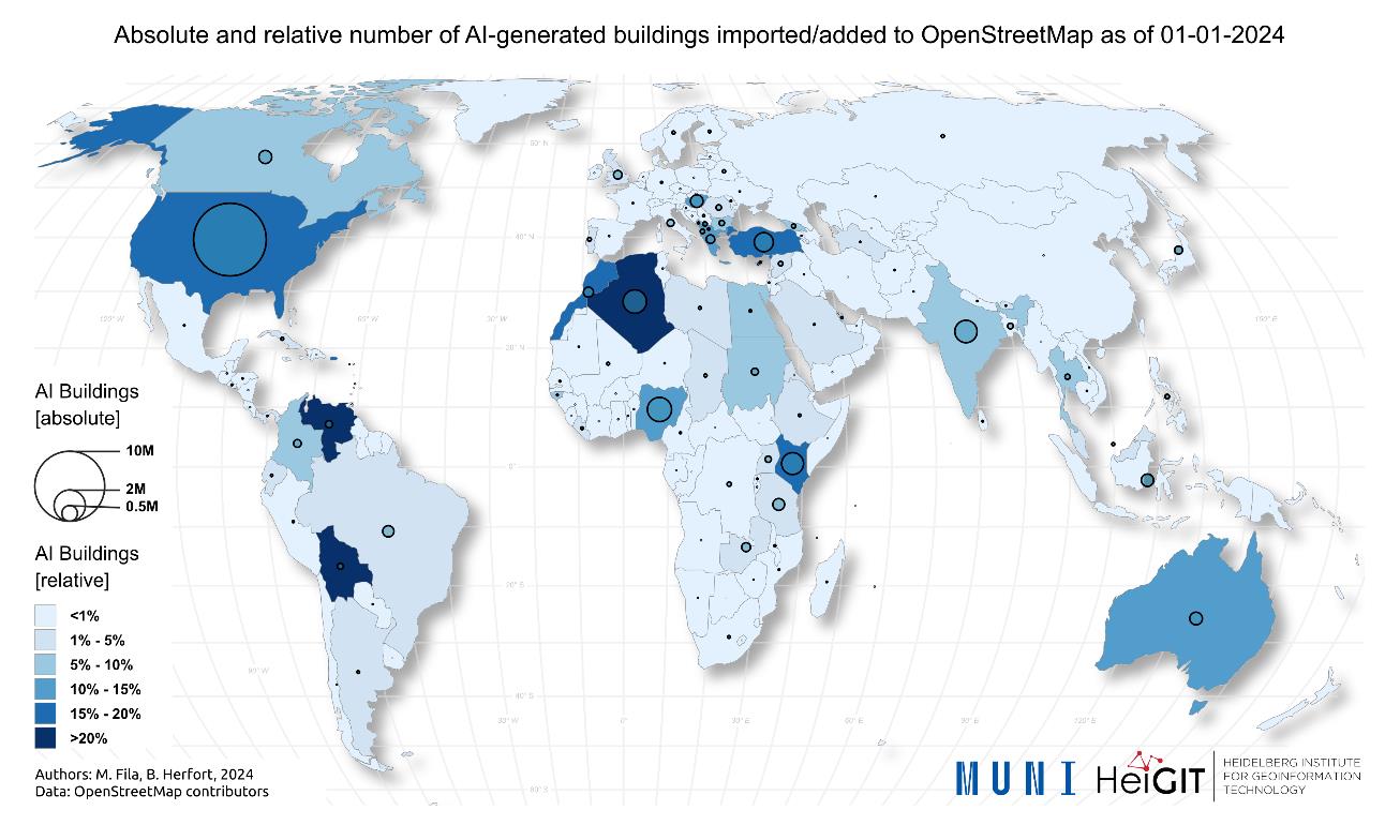
This research highlights the potential of AI-assisted mapping in OSM while acknowledging its challenges. AI-generated buildings are identifiable but unevenly distributed, with 75% concentrated in five countries: the USA, Nigeria, Algeria, India, and Kenya. The source tags recommended by data providers are generally sufficient for identifying AI-generated buildings. Road identification remains problematic, hence it could not be addressed in this paper.
AI-generated buildings are modified less frequently than human-contributed data, reflecting patterns observed in humanitarian mapping, where large-scale mapping efforts are often conducted in response to crises but see limited updates over time. While AI-assisted mapping exhibits a positive correlation with population size, it has no relationship to a country’s Human Development Index (HDI) or the size of its mapping community. This sets it apart from both general and humanitarian mapping, which are more strongly influenced by economic development and community engagement.
While the quality of AI-generated data generally aligns with assessments from data providers, regional variations exist. Some areas have well-mapped AI-generated buildings, whereas others still contain significant gaps. This suggests that while AI models effectively identify many buildings, they do not detect all structures, leaving portions of the built environment unmapped.
At the same time, AI-assisted mapping generates a substantial volume of data, yet it is likely carried out by a relatively small group of mappers. The quality of AI-generated building data was assessed for a selected location with a high proportion of AI-generated buildings. The analysis showed that the measured quality values were generally consistent with those reported by data providers such as Microsoft. However, while the AI-generated dataset successfully identified many buildings, a significant number of existing structures remained undetected, highlighting the need for further improvements in AI-assisted mapping techniques.
Future research should focus on standardized tagging, AI’s impact on mapping communities, and open-source AI models for region-specific improvements. In this context, the Humanitarian OpenStreetMap Team (HOT) is developing fAIr, an AI-assisted mapping platform designed to to improve the efficiency and accuracy of mapping efforts for humanitarian purposes. All research collaborators of this study have contributed to the development of the platform, either by doing a quality assessment or by working on joint projects with HOT team.
Addressing the issues of AI-assisted mapping through a community-driven approach grounded in fairness, accountability, and transparency , initiatives like fAIr can strengthen OSM’s role as a digital public good and improve global spatial data accessibility.
This paper stems from academic collaboration between HeiGIT & Heidelberg University and Masaryk University, Brno. Through the Erasmus+ program, Milan Fila and Radim Stampach visited Heidelberg researchers and then Benjamin Herfort spent a week in Masaryk University working on this collaborative paper as well as giving a lecture and a public talk.
Reference: Fila, M., Štampach, R., & Herfort, B. (2025). AI-generated buildings in OpenStreetMap: frequency of use and differences from non-AI-generated buildings. International Journal of Digital Earth, 18(1). https://doi.org/10.1080/17538947.2025.2473637
Related talk: https://2023.stateofthemap.eu/program/global-and-regional-level-of-use-of-buildings-and-roads-prepared-by-ai-for-osm-mapping
Title image: Absolute and relative numbers of AI-generated buildings in OpenStreetMap, as of 1 January 2024. Created using QGIS 3.34.3.