Kennen Sie afrikanische Studierende, die gerne an der Universität Heidelberg studieren würden? Die Bewerbungsfrist für das Robert-und-Christine-Danziger-Stipendium ist bis zum 31. August verlängert worden. Angehende Masterstudenten und Doktoranden aus Afrika,…
Damit Geoinformationen sicher und einfach genutzt werden können und Hilfsorganisationen bei Katastrophen bessere Orientierung haben, gibt es das HeiGIT. Unterwegs in einer fremden Stadt? Kein Problem, jedes normale Smartphone hat…
Heidelberg University has awarded the title adjunct professor (außerplanmäßiger Professor) to HeiGIT member Dr. Sven Lautenbach. As a member of the faculty of chemistry and geosciences he is allowed (and…
CALL FOR PAPERS – 18th International Conference on Information Systems for Crisis Response and Management (ISCRAM 2021) May 23-26, 2021, Virginia, USA – https://www.drrm.fralinlifesci.vt.edu/iscram2021/ Virginia Tech Track: Geospatial Technologies and…
Am 02.07. besuchte eine Delegation von Alumni von “Jugend präsentiert” im Rahmen der diesjährigen Summer School REMOTE von “Jugend präsentiert” das Heidelberg Institute for Geoinformation Technology (HeiGIT gGmbH) an der…
Today (1st July 2020) marks the first birthday of HeiGIT gGmbH! Over this first year, HeiGIT has been involved a large number of events, projects, publications, and press coverage. Founded…
25 Jahre Klaus Tschira Stiftung: KTS fördert zum Jubiläum zahlreiche 25er Aktionen – HeiGIT mit 25 Mapathons dabei In diesem Jahr wird die Klaus Tschira Stiftung (KTS) 25 Jahre alt….
As noted in a previous blogpost, the scientific committee of the Academic Track of State of the Map 2019 – Dr. Yair Grinberger, until recently a member of the GIScience…
The deadline for the Call for Papers for a special issue of Transactions of GIS on “The Geographical and Cultural Aspects of Geo-Information” had been extended to the 31 January…
Dear friends and colleagues, we wish you a relaxing and peaceful holiday season and all the very best for a happy and prosperous New Year. The most important event of…
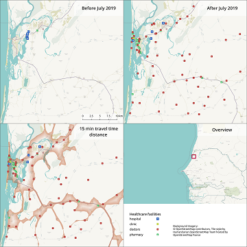
The Global Healthsites Mapping Project (Healthsites) and the Heidelberg Institute for Geoinformation Technology/ GIScience Research Group are happy to announce the now also formal cooperation. Last week, HeiGIT/ GISciences signed…
Last June, colleagues from the GIScience group – Dr. Tessio Novack, Dr. Michael Schultz and Prof. Dr. Alexander Zipf – together with Dr. Peter Mooney (Maynooth University, Ireland) and Dr….
Over the last few days, Heidelberg’s first climathon event took place at EMBL, which was part of the global Climathon. The event ran from 25th-27th October 2019 with a 24…
Rapid worldwide urbanization benefits humans in many aspects, but the prevalence of common psychiatric disorders is increased in urban populations. While the impact of city living and urban upbringing on…
Der Fachaustausch Geoinformation Heidelberg des GeoNet.MRN wird dieses Jahr geoActive! Im Fokus sind dieses Jahr Themen Mobilität und Baustellen in der Session mobiActive! sowie Klimawandel und Nachhaltigkeit in der Session…
Rapid worldwide urbanization benefits humans in many aspects, but the prevalence of common psychiatric disorders is increased in urban populations. While the impact of city living and urban upbringing on…
Wer steckt eigentlich hinter Missing Maps? Und wie können auch Sie in dem humanitären Mappingprojekt aktiv werden? Besuchen Sie uns heute beim Tag der offenen Tür im Auswärtigem Amt an…
INTERDISZIPLINÄRE STUDIE ZEIGT, DASS INNERSTÄDTISCHES GRÜN UNMITTELBAR EINFLUSS AUF STADTBEWOHNER HAT Innerstädtische Grünflächen wie Rasen, Blumenbeete, Bäume oder Parks können unmittelbar das Wohlbefinden im Alltag von Stadtbewohnern verbessern. Das zeigt…
GIScience will be present with two participants (Nicole Aeschbach, TdLab Geographie) and Sven Lautenbach (HeiGIT) at the german IPCC conference. Our contributions aim at highlighting the potential of GIScience and…
GIScience/HeiGIT member Sven Lautenbach is hosting together with Jonas Schwaab from the ETH Zürich a session on Multi-objective optimization approaches to support visioning and decision-making in land-use system science at…