Next week the HOT Summit will take place. The conference takes already place for the sixth time and it is the fifth consecutive time that we from HeiGIT/GIScience Heidelberg do contribute a session. This years topic is 10 Years of Humanitarian OpenStreetMap: The Past, Present, and Future of Humanitarian Mapping. It will be a one day conference in conjunction with the Understand Risk conference and happens on Friday 4th December. The fully virtual conference is organized in three blocks across several time zones, to reflect a truly global event.
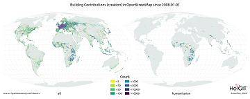
Benjamin Herfort from HeiGIT will participate together with Hannah Ker (MapAction) and Geoffrey Kateregga (HOT) in an extended dialogue session towards the sustainability of community engagement and data production in humanitarian mapping activities. In our session we want to explore what humanitarian mapping in OSM looks like and if it is serving the community in a sustainable way. You can take a look at our slides already here and get prepared with questions and comments in advance.
Marcel Reinmuth (HeiGIT) will contribute a lightning talk: OpenStreetMap for healthcare access.
In which he will present latest results on using OSM data for healthcare access estimations and a brief overview on what is missing in healthcare data in OSM. Here you can see the slides and links to further resources.
Related work and Links:
- Geldsetzer, P.; Reinmuth, M.; Ouma, P. O., Lautenbach, S.; Okiro E. A.; Bärnighausen, T.; Zipf, A. Mapping physical access to health care for older adults in sub-Saharan Africa and implications for the COVID-19 response: a cross-sectional analysis. The Lancet Healthy Longevity. 2020;1(1):e32-e42.
- Scholz, S., Knight, P., Eckle, M., Marx, S., Zipf, A. (2018): Volunteered Geographic Information for Disaster Risk Reduction: The Missing Maps Approach and Its Potential within the Red Cross and Red Crescent Movement. Remote Sens., 10(8), 1239, doi:10.3390/rs10081239.
- Herfort, Benjamin; Raifer, Martin; Reinmuth, Marcel; Stier, Jochen; Klerings, Alina (2020): Evolution of humanitarian mapping within the OpenStreetMap Community. Talk at the State of the Map conference 2020, Cape Town.
- Auer, M.; Eckle, M.; Fendrich, S.; Griesbaum, L.; Kowatsch, F.; Marx, S.; Raifer, M.; Schott, M.; Troilo, R.; Zipf, A. (2018): Towards Using the Potential of OpenStreetMap History for Disaster Activation Monitoring. ISCRAM 2018. Rochester. NY. US.
- Albuquerque, J. P., B. Herfort, and M. Eckle. “The tasks of the crowd: A typology of tasks in geographic information crowdsourcing and a case study in humanitarian mapping.” Remote Sensing 8.10 (2016): 859.
- Humanitarian OSM Stats Website and Intro Blogpost

