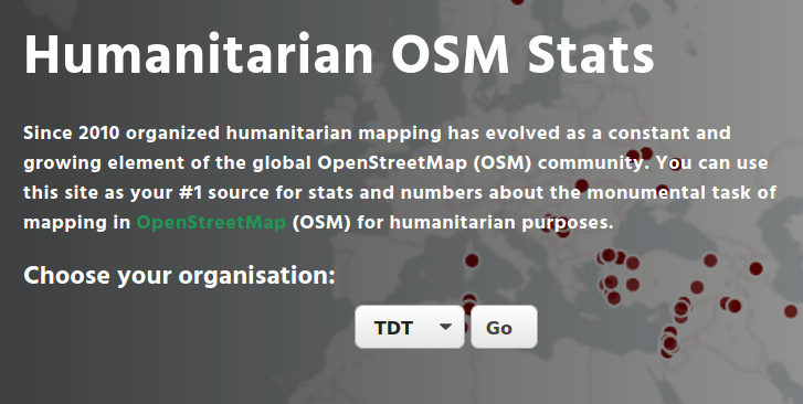
Since 2010, organized humanitarian mapping has evolved as a constant and growing element of the global OpenStreetMap (OSM) community. With more than 7,000 projects in 150 countries, humanitarian mapping has become a global community effort. Due to this large amount of projects, it can be difficult to get an overview on mapping activity. This is why we worked on the “Humanitarian OSM Stats” website humstats.heigit.org to make it easier to find the information you are looking for. It combines data from the open-source Tasking Manager, hosted by the Humanitarian OpenStreetMap Team, (HOT) and information from the OpenStreetMap (OSM) that has been processed using the ohsome OSM History Data Analytics Platform developed by HeiGIT.
As in our previous post, we will take a look at the mapping organized by Médecins Sans Frontières (MSF). Since 2016, MSF has created mapping campaigns both in response to emergency situations, such as the epidemic outbreaks, but also for pre-emptive mapping ahead of a possible programme development. Here, we will focus on MSF’s mapping activity in three countries: the Democratic Republic of Congo (DRC), Central African Republic (CAR) and Venezuela.
Goals
In this blog post, we will pursue three relatively easy goals:
- How many buildings and highways have been added to OSM for the three selected countries?
- How many volunteers have contributed to this effort?
- How long did the mapping activity last? (When did it start and finish?)
Finally, we will set these numbers into the context of field missions and how mapping in OSM has supported MSF’s work to help people in the three countries.
How to get the information from the website
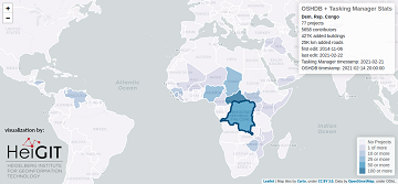
- Visit the humstats.heigit.org website and select your organization and click on “go”. This will direct you to a new site with the statistics for the selected organization.
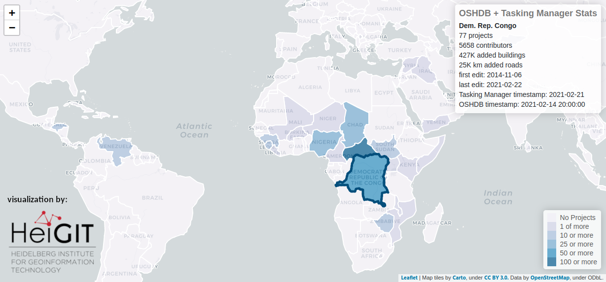
- Details about the mapping in each country is provided in the map below. You can hover with the mouse over the map and get more insights. Overall, the Central African Republic is the country for which most of MSF’s mapping happened, when it comes to the number of projects. This is especially remarkable since mapping has only started in February 2019. DRC is one of the countries where MSF’s mapping in OpenStreetMap has started. Since the start of the Missing Maps project in November 2014, volunteers worked on more than 77 MSF projects there. This effort is continued up to today with the ongoing campaign to MapSouthKivu. Venezuela is the only South American country where MSF has had HOT Tasking Manager projects. This region is relatively new on MSF’s list; mapping has been organized there for the last 2.5 years. In general, most MSF mapping projects are located in Africa with only very few exceptions. For the three countries, you find a summary in the table below.
|
Country |
Democratic Republic Congo |
Central African Republic |
Venezuela |
|
number of projects |
77 |
148 |
20 |
|
buildings added |
427,344 |
341,963 |
81,706 |
|
highways added |
24,832 km |
3,701 km |
194 km |
|
OSM users |
5,658 |
5,030 |
1,415 |
|
first edit |
2014-11-06 |
2019-02-14 |
2018-09-14 |
|
last edit |
2021-02-22 |
2021-02-15 |
2021-02-18 |
Step 2: Check countries on the map for number of project and contributors in the Tasking Manager and OSM statistics.
In the Democratic Republic of Congo, selected in the map above, Missing Maps projects helped MSF to update maps in preparation for an ebola outbreak response in 2018, including field mapping health facilities in Goma, described in detail here. To this day, Missing Maps volunteers keep mapping the North and South Kivus. This contributes to provide a more accurate estimate of the population count and spread in areas where many people have been displaced, follow the epidemiological situation and facilitate the provision of healthcare.
The recently completed mapping campaign in Delta Amacuro, Venezuela, is an example of preemptive mapping for possible future work of MSF in an area with vulnerable communities and a difficult access.
In the Central Africa Republic, MSF and volunteers have mapped on projects in several provinces ahead of a planned mortality survey, and to support MSF programmes in the country.
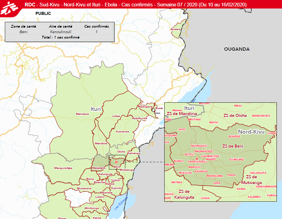
Figure 3: A cutout from an MSF map using OSM, DRC – Ituri and the Kivus, July 2020.
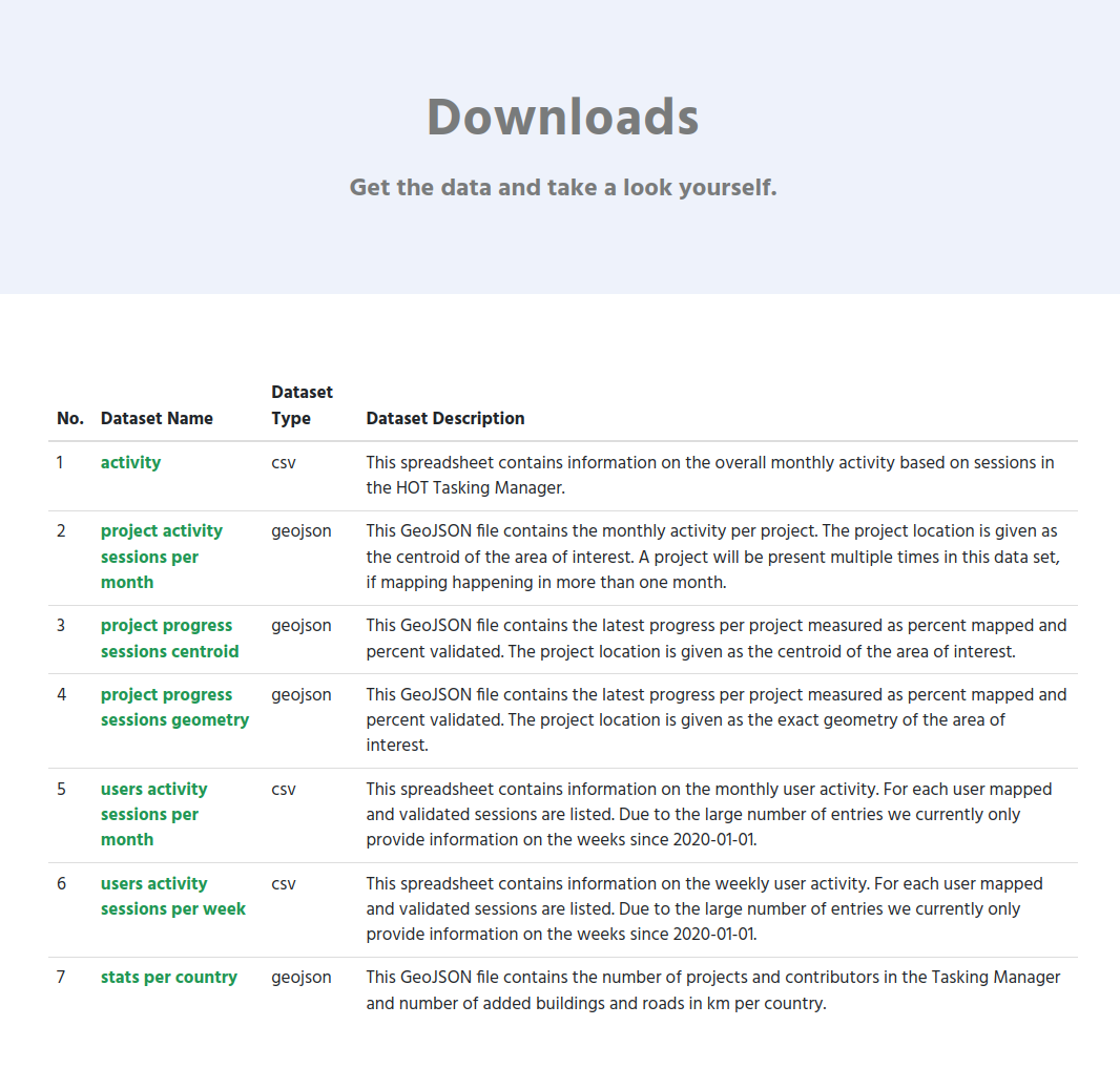
Download the data as a geojson file
If you are interested to get the data behind these numbers and plots continue reading. On the website we offer a list of files to download. The stats_per_country.geojson is the ones that you need for the purpose described in this blog post. For instance, for MSF, this file will be located here: https://humstats.heigit.org/api/export/msf/stats_per_country.geojson.
To be continued
This is the fourth blog post of a series of posts we are currently working on. If you are interested please reach out to us (benjamin.herfort@heigit.org) and we can try to cover your questions in a future post.
In the next blog of this series we will take a closer look at American Red Cross’ validation efforts.
Selected Related Publications
Herfort, B., Lautenbach, S., Porto de Albuquerque, J., Anderson, J., Zipf, A.The evolution of humanitarian mapping within the OpenStreetMap community. Scientific Reports 11, 3037 (2021). DOI: 10.1038/s41598-021-82404-z https://www.nature.com/articles/s41598-021-82404-z
Raifer, Martin; Troilo, Rafael; Kowatsch, Fabian; Auer, Michael; Loos, Lukas; Marx, Sabrina; Przybill, Katharina; Fendrich, Sascha; Mocnik, Franz-Benjamin; Zipf, Alexander (2019): OSHDB: a framework for spatio-temporal analysis of OpenStreetMap history data. Open Geospatial Data, Software and Standards.
Auer, M.; Eckle, M.; Fendrich, S.; Griesbaum, L.; Kowatsch, F.; Marx, S.; Raifer, M.; Schott, M.; Troilo, R.; Zipf, A. (2018): Towards Using the Potential of OpenStreetMap History for Disaster Activation Monitoring. ISCRAM 2018. Rochester. NY. US.
Scholz, S., Knight, P., Eckle, M., Marx, S., Zipf, A. (2018): Volunteered Geographic Information for Disaster Risk Reduction: The Missing Maps Approach and Its Potential within the Red Cross and Red Crescent Movement. Remote Sens., 10(8), 1239, doi:10.3390/rs10081239.