The Horizon 2020 LandSense project was concluded successfully. Please find a selection of the produced publications and deliverables here. The project has enabled our group to pursue quality aspects of voluntarily collected geo information data and to ramp up efforts related to OSMlanduse.
Together with the University of Nottingham (Giles Foody) and Institut national de l’information géographique et forestière France (Ana-Maria Olteanu-Raimond) the GIScience Heidelberg group was leading the quality assurance and quality control of the largest Horizon 2020 Citizen Science Project, providing accuracy, performance and benchmark services for six citizen science pilot projects.
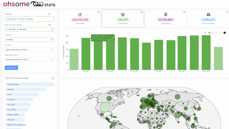
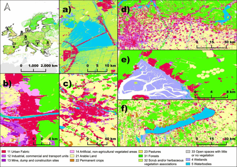
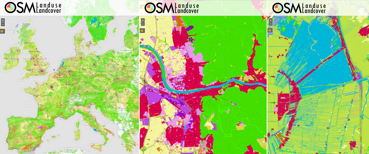
One of the key aspects for the quality estimation was the collection of reference data for OSMlanduse where you can find the latest edition of our mapathon campaigns here. For OSMlanduse and its integration with our mapathon data as well as additional auxiliary remote sensing data we’re using HeiGIT’s OSM big data processing platform ohsome an in-house labor of love, handcrafted in Java and Python, using only hand picked, organic, free license libraries (https://github.com/GIScience). We are currently concluding results and making produced models and validation data collected publicly available.
We do cordially thank for the excellent collaboration among our partners and are thankful for the extended collaboration within follow up projects!

https://www.geog.uni-heidelberg.de/gis/land_sense.html
Our Project Publications
- Schultz, M., Voss, J., Auer, M., Carter, S., and Zipf, A. (2017): Open land cover from OpenStreetMap and remote sensing. International Journal of Applied Earth Observation and Geoinformation, 63, pp. 206-213. DOI: 10.1016/j.jag.2017.07.014.
- Yan, Y., Schultz, M., Zipf, A. (2019): An exploratory analysis of usability of Flickr tags for land use/land cover attribution, Geo-spatial Information Science (GSIS), Taylor & Francis. https://doi.org/10.1080/10095020.2018.1560044
- Long, G., Schultz, M., Olteanu-Raimond, A.-M. (2020): Good practice guidelines, protocols and benchmarking standards for quality assurance. H2020 LandSense. https://zenodo.org/record/4133626
- Capellan, S., Stickler, T., Birli, B., Olteanu-Raimond, A.-M., Schultz, M., Mrkajic, V., Moorthy, I. (2020): Engagement action plans and campaign strategies for LandSense demonstration cases I. H2020 LandSense. https://zenodo.org/record/3670135
- Moorthy, I., See, L., Banko, G., Capellan, S., Mrkajic, V., Olteanu-Raimond, A.-M., Schrammeijer, B., Schultz, M., Batič, M., Fritz, S. (2020): LandSense: Coupling citizen science and earth observation data to promote environmental monitoring. H2020 LandSense. https://zenodo.org/record/4146846
- Stickler, T., Raimond, A.-M., Schrammeijer, B., Schultz, M. (2020): Cost Reduction and data conflation in monitoring land change. H2020 LandSense. https://zenodo.org/record/3670904
- Schultz, M. (2018): Definition of citizen-observed and authoritative data collection requirements for LandSense demonstration cases. H2020 LandSense. https://doi.org/10.5281/zenodo.3670341
- Raimond, A.-M., See L., Schultz, M., Foody, G., Jolivet, L., Le Bris, A., Meneroux, Y., Liu, L., Poupee, M., Gombert, M. (2020): Use of Automated Change Detection and VGI for Identifying and Validating Urban Land Use Change. Remote Sensing.
- Voß J., Auer M., Schultz M., Zipf A. (2017): Einsatz von OpenStreetMap Daten zur Erstellung von Landnutzungsprodukten am Beispiel von OSM Landuse Landcover. Symposium für Angewandte Geoinformatik AGIT 2017. Salzburg.
Related & earlier work at GIScience/HeiGIT (selection)
- Li, H.; Ghamisi, P.; Rasti, B.; Wu, Z.; Shapiro, A.; Schultz, M.; Zipf, A. A Multi-Sensor Fusion Framework Based on Coupled Residual Convolutional Neural Networks. Remote Sensing. 2020, 12, 2067. DOI: https://doi.org/10.3390/rs12122067
- Raifer, M., Troilo, R., Kowatsch, F., Auer, M., Loos, L., Marx, S., Przybill, K., Fendrich, S., Mocnik, F.-B.& Zipf, A. (2019): OSHDB: a framework for spatio-temporal analysis of OpenStreetMap history data.Open Geospatial Data, Software and Standards 2019 4:3. https://doi.org/10.1186/s40965-019-0061-3
- Ludwig, C.; Fendrich, S.; Zipf, A. (2020): Regional variations of context‐based association rules in OpenStreetMap. Transactions in GIS. Wiley. https://doi.org/10.1111/tgis.12694
- Li, H., Herfort, B., Zipf, A. (2019): Estimating OpenStreetMap Missing Built-up Areas using Pre-trained Deep Neural Networks. Proceedings of the 22nd AGILE Conference on Geographic Information Science, Limassol, Cyprus.
- Wu, Zhaoyan, Li, Hao, & Zipf, Alexander. (2020). From Historical OpenStreetMap data to customized training samples for geospatial machine learning. In proceedings of the Academic Track at the State of the Map 2020 Online Conference, July 4-5 2020. DOI: http://doi.org/10.5281/zenodo.3923040
- Ludwig, Christina ; Zipf, Alexander (2019): Exploring regional differences in the representation of urban green spaces in OpenStreetMap. Proceedings of the GeoCultGIS – Geographic and Cultural Aspects of Geo-Information: Issues and Solutions, Limassol (Cyprus).
- Yan, Y., C. Feng, W. Huang, H. Fan, Y. Wang & A. Zipf (2020): Volunteered geographic information research in the first decade: a narrative review of selected journal articles in GIScience. International Journal of Geographical Information Science, DOI: 10.1080/13658816.2020.1730848
- Strauch, M., Cord, A.F., Pätzold, C., Lautenbach, S., Kaim, A., Schweitzer, C., Seppelt, R., Volk, M. (2019): Constraints in multi-objective optimization of land use allocation – repair or penalize? Environmental Modelling & Software, 2019. https://doi.org/10.1016/j.envsoft.2019.05.003
- Geiß, C., Schauß, A., Riedlinger, T. et al. (2016): Joint use of remote sensing data and volunteered geographic information for exposure estimation: evidence from Valparaíso, Chile. Natuaral Hazards (2016). pp 1–25. doi:10.1007/s11069-016-2663-8
- Dorn, H., Törnros, T. & Zipf, A. (2015): Quality Evaluation of VGI using Authoritative Data – A Comparison with Land Use Data in Southern Germany. ISPRS International Journal of Geo-Information. Vol 4(3), pp. 1657-1671, doi: 10.3390/ijgi4031657
- Jokar Arsanjani, J., Helbich, M., Bakillah, M., Hagenauer,J. & Zipf, A. (2013): Toward mapping land-use patterns from volunteered geographic information. International Journal of Geographical Information Science (IJGIS). Taylor & Francis. DOI: 10.1080/13658816.2013.800871.
- Jokar Arsanjani, J., Mooney, P., Helbich, M., Zipf, A., (2015): An exploration of future patterns of the contributions to OpenStreetMap and development of a Contribution Index, Transactions in GIS, 19(6): 896–914. John Wiley & Sons. DOI: 10.1111/tgis.12139.
- Barron, C., Neis, P. & Zipf, A. (2013): A Comprehensive Framework for Intrinsic OpenStreetMap Quality Analysis. , Transactions in GIS, DOI: 10.1111/tgis.12073.