Humans rely on clean water for their health, well-being, and various socio-economic activities. During the past few years, the COVID-19 pandemic has been a constant reminder of about the importance of hygiene and sanitation for public health. The most common approach to securing clean water supplies for this purpose is via wastewater treatment. To date, an effective method of detecting wastewater treatment plants (WWTP) accurately and automatically via remote sensing is unavailable. Together with a team from the University of Heidelberg, HeiGIT, Chinese Academy of Sciences (CAS), Helmholtz-Zentrum Dresden-Rossendorf (HZDR), and Institute of Advanced Research in Artificial Intelligence (IARAI), we have recently published a scientific paper to tackle this challenge, which is now openly available in International Journal of Applied Earth Observation and Geoinformation.

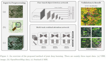
In this paper, we provide a solution to this task by proposing a novel joint deep learning (JDL) method that consists of a fine-tuned object detection network and a multi-task residual attention network (RAN). By leveraging OpenStreetMap (OSM) and multimodal remote sensing (RS) data, our JDL method is able to simultaneously tackle two different tasks: land use land cover (LULC) and WWTP classification. Moreover, JDL exploits the complementary effects between these tasks for a performance gain. We train JDL using 4,187 WWTP features and 4,200 LULC samples and validate the performance of the proposed method over a selected area around Stuttgart with 723 WWTP features and 1,200 LULC samples to generate an LULC classification map and a WWTP detection map. Extensive experiments conducted with different comparative methods demonstrate the effectiveness and efficiency of our JDL method in automatic WWTP detection in comparison with single-modality/single-task or traditional survey methods. Moreover, lessons learned pave the way for future works to simultaneously and effectively address multiple large-scale mapping tasks (e.g., both mapping LULC and detecting WWTP) from multimodal RS data via deep learning.
In conclusion, the proposed method offers a promising solution of automatic WWTP detection by consuming freely available VGI data and multimodal RS data, which also shows great potential in business applications.
Li, H., Zech, J., Hong, D., Ghamisi, P., Schultz, M., Zipf, A. (2022) Leveraging OpenStreetMap and Multimodal Remote Sensing Data with Joint Deep Learning for Wastewater Treatment Plants Detection. International Journal of Applied Earth Observation and Geoinformation, Volume 110, June 2022, 102804, https://doi.org/10.1016/j.jag.2022.102804
Previous related work:
- Li, H. J. Zech, C. Ludwig, S. Fendrich, A. Shapiro, M. Schultz, A. Zipf (2021): Automatic mapping of national surface water with OpenStreetMap and Sentinel-2 MSI data using deep learning.. International Journal of Applied Earth Observation and Geoinformation, Vol 104, 2021, 102571. https://doi.org/10.1016/j.jag.2021.102571.
- Li, H.; Ghamisi, P.; Rasti, B.; Wu, Z.; Shapiro, A.; Schultz, M.; Zipf, A. A Multi-Sensor Fusion Framework Based on Coupled Residual Convolutional Neural Networks. Remote Sensing. 2020, 12, 2067. DOI: https://doi.org/10.3390/rs12122067
- Li, H., Herfort, B., Huang, W., Zia, M., and Zipf, A. (2020): Exploration of OpenStreetMap Missing Built-up Areas using Twitter Hierarchical Clustering and Deep Learning in Mozambique. ISPRS Journal of Photogrammetry and Remote Sensing. https://doi.org/10.1016/j.isprsjprs.2020.05.007
- Herfort, B., Li, H., Fendrich, S., Lautenbach, S., Zipf, A. (2019): Mapping Human Settlements with Higher Accuracy and Less Volunteer Efforts by Combining Crowdsourcing and Deep Learning. Remote Sensing 11(15), 1799. https://doi.org/10.3390/rs11151799
- Y. Yan, M. Schultz & A. Zipf (2019): An exploratory analysis of usability of Flickr tags for land use/land cover attribution, Geo-spatial Information Science, DOI: 10.1080/10095020.2018.1560044
- Schultz, M., Voss, J., Auer, M., Carter, S., and Zipf, A. (2017): Open land cover from OpenStreetMap and remote sensing. International Journal of Applied Earth Observation and Geoinformation, 63, pp. 206-213. DOI: 10.1016/j.jag.2017.07.014
- Jokar Arsanjani, J., Helbich, M., Bakillah, M., Hagenauer, J., & Zipf, A. (2013). Toward mapping land-use patterns from volunteered geographic information. International Journal of Geographical Information Science, 2264-2278. DOI:10.1080/13658816.2013.800871.
- Jokar Arsanjani, J., Mooney, P., Zipf, A., Schauss, A., (2015): Quality assessment of the contributed land use information from OpenStreetMap versus authoritative datasets. In: Jokar Arsanjani, J., Zipf, A., Mooney, P., Helbich, M., OpenStreetMap in GIScience: experiences, research, applications. ISBN:978-3-319-14279-1, PP. 37-58, Springer Press.