Humanitarian mapping activations show increasing numbers of contribution. This blog post illustrates the specific potential of the OSHDB API [1] for detailed analyses of such activations by means of a case study. The examined area is Cox’s Bazar in Southeast Bangladesh, where almost 1 million Rohingya refugees fled to from Myanmar in 2015. In order to support the coordination of humanitarian response to the refugee crisis, field mapping was conducted by CartONG and MSF [2]. Also the OpenStreetMap (OSM) community was involved mapping shelter footprints and roads remotely from drone imagery. The remote mapping in OSM was coordinated through the HOT Tasking Manager [3] and included 23 different refugee camps in Bangladesh, spread over an area of approximately 15 km².
Examining the data evolution gives insight on the time volunteers need to create new OSM data or update the map. Knowledge about possible challenges like few skilled vs. many unexperienced mappers are useful to improve the quality of the mapping result. The following analysis covers statistics regarding the activity of OSM contributors, the ratio of creations, modifications and deletions of mapped entities as well as the total duration of the mapping process. In order to perform this analysis on the respective OSM full history data, the OSHDB API was utilized. The API has various views and filtering options that enable the extraction of specific data selections. In the following, the applied filters and their results will be discussed.
Mapping Activity
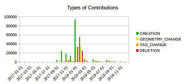
The temporal analysis shows that the mapping activity increased considerably in the second year, with new creations of entities making up the biggest share of contributions, followed by modifications of geometries and tag values and deletions, see chart below. This trend can be observed across all 23 individual camp sites.

Most of the contributors started working from October 2017 on wards, which indicates that the mapping project took a while to properly get started.
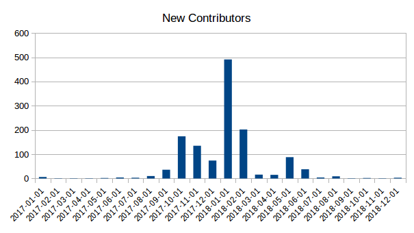
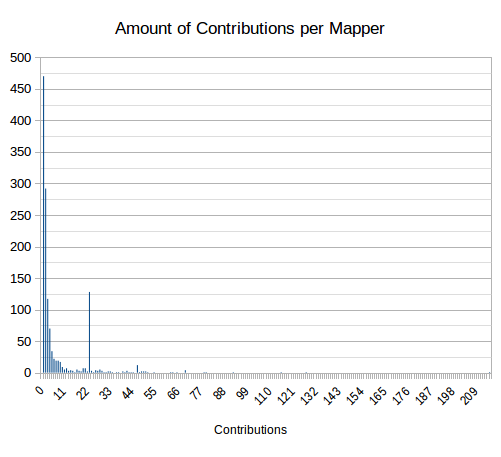
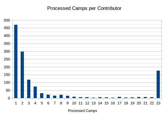
Over the course of two years, over 1300 people took part in the mapping process, with an average of 333 mappers working on the outlines of one camp. The vast majority of contributors was only active on a small scale (Ø ~8 contributions), for a short period of time (Ø ~16 days), working on 5 different camps or less, see histograms below. However, there are a few mappers who mapped over a longer timespan, contributing to (almost) every camp.
Mapping of Highways
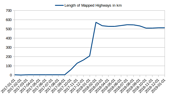
Getting an overview of the existing road network in the camps was one of the major concerns. For humanitarian crisis response in the field it is of utmost importance to have information on road width and possible steps restricting the use of 4-wheel vehicles in order to ensure effective supply. In total, over 500 kilometers of highway were mapped in the refugee camps, with a temporary decline visible in the plot below, due to corrections. The graph shows that by February 2018, the core part of the road network was fully covered and only minor modifications were made afterwards.
After two years of mapping (January 2019), the majority of the highway lengths was tagged with
- path (90.7%): roads too narrow for a 4-wheel vehicle to pass,
- track (4.6%): roads connecting the camps to fields
- residential (3.2%): roads for 4-wheel vehicles and
- steps (1.1%).
The analysis also shows that some tag values (e.g. living_street) only occurred temporary, suggesting that they got replaced by others tags which increase during the same time.
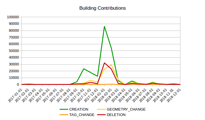
Mapping of Buildings/Shelters
Similar to the evolution of OSM highways, the mapping of buildings only got rolling in October 2017. After two years, a total of almost 120,000 shelters were mapped across all camps.

Conclusion
The mapping process of the Rohingya camps in Bangladesh reveals that collecting OSM data is a dynamic process. Initially set guidelines for preferred tags and objects of interest may be adapted over the course of time, in order to meet the requirements of response teams on site or other users of the OSM data. While having a great number of active contributors can speed up the mapping process, it can also lead to inconsistency between tags requiring additional edits.
[1] Raifer, M., Troilo, R., Kowatsch, F. et al. OSHDB: a framework for spatio-temporal analysis of OpenStreetMap history data. Open geospatial data, softw. stand. 4, 3 (2019)
[2] HOT Task: https://tasks.hotosm.org/project/4891
[3] Building a lasting GIS infrastructure in a camp setting: a 4-week mission in Bangladesh in support of MSF France, (2018). cartONG. URL: https://www.cartong.org/news/building-lasting-gis-infrastructure-MSF