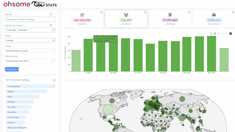
Slums are an important operational area for humanitarian organisations: Because of provisional housing, poor sanitation and difficult socio-political circumstances offers of help from such organisations are important and often necessary. For such deployments, humanitarian actors rely heavily on Volunteered Geographic Information (VGI), as official maps and data are often incomplete. This makes it all the more difficult that there is a lack of high-quality spatial data for slums.
Analysing seven study sites in Asia and Africa, the authors have developed 4 novel definitions of completeness based on the total number, length and area of OSM Objects such as buildings and routes at the end of the study and at an arbitrary timestamp. This allows for assessing the completeness of these objects at any time during the mapping process retrospectively and estimating potential disparities.
- The completeness of the building count at an arbitrary timestamp.
- The completeness of the building area at an arbitrary timestamp.
- The completeness of the road count at an arbitrary timestamp.
- The completeness of road length at an arbitrary timestamp.
Furthermore, the completeness growth of an OSM element at a certain stage (in percent) as well as the completeness growth of an OSM element per mapper at a certain stage (in percent) can be calculated using the completeness growth and the total number of active mappers.
These measures were used to compare two data sources: (1) In a first step, both experienced and trained inexperienced contributors mapped the study sites online, using the Humanitarian OSM Team (HOT) Tasking manager as a coordination interface. (2) In a second step, local mappers conducted fieldwork and mapped the area using portable GPS devices.
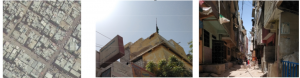
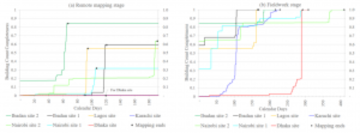
Fig 1: Imagery of the slum in Karachi: (a) Sample of satellite imagery, (b) Sample of building, (c) Sample of route (Yeboah et al. 2021, p. 8)
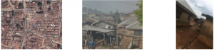
Fig. 2: Imagery of the slum at Ibadan site 2: (d) Sample of satellite imagery, (e) Sample of building, (f) Sample of route (Yeboah et al. 2021, p. 9)
As figure 3 shows, the completeness achieved by remote mapping varied greatly between 0 and 84% between the study sites. This was influenced by two main criteria: the density of the buildings and the rooftop architecture. For slums with a complex morphology, such as the study sites in Karachi and Dhaka (see Fig. 1), no building completeness could be achieved. Slums with a more clear and consistent morphology, such as the Ibadan study sites (see Fig. 2), the highest completeness could be achieved. Routes are easier to interpret: Here, a completeness of up to 73% could be achieved. Therefore, it is suggested that if the satellite imagery shows a morphologically complex area, the main mapping-effort should lie on the routes and striking landmarks, as they are crucial for orientation during fieldwork.

Fig. 3: Completeness of buildings. (a) During remote mapping stage. (b) During fieldwork stage (Yeboah et al. 2021:12).
Reference: https://www.mdpi.com/2220-9964/10/4/265
Yeboah, G., Porto de Albuquerque, J., Troilo, R., Tregonning, G., Perera, S., Ahmed, S. A., … & Yusuf, R. (2021). Analysis of OpenStreetMap Data Quality at Different Stages of a Participatory Mapping Process: Evidence from Slums in Africa and Asia. ISPRS International Journal of Geo-Information, 10(4), 265.