In the past 10 years, the collaborative maps of OpenStreetMap (OSM) have been used to support humanitarian efforts around the world as well as to fill important data gaps for implementing major development frameworks such as the Sustainable Development Goals (SDGs). In a recently accepted paper we provide a comprehensive assessment of the evolution of humanitarian mapping within the OSM community, seeking to understand the spatial and temporal footprint of these large-scale mapping efforts. The paper is published in the Scientific Reports Journal by Nature and available as “open access” https://www.nature.com/articles/s41598-021-82404-z :
- Herfort, B., Lautenbach, S., Porto de Albuquerque, J., Anderson, J., Zipf, A.The evolution of humanitarian mapping within the OpenStreetMap community. Scientific Reports 11, 3037 (2021). DOI: 10.1038/s41598-021-82404-z
This analysis encompasses all humanitarian mapping projects organized through the HOT Tasking Manager since 2012 (start of the available data), enabling us — for the first time — to cast a longitudinal perspective on the intersecting effects of mapping efforts, socio-economic, and demographic characteristics. This analysis provides critical insights into the achievements of humanitarian mapping so far, by combining data about OSM humanitarian mapping with statistics on global population distribution and human development at the sub-national level.
We conclude with three recommendations directed at the humanitarian mapping community:
- Improve methods to monitor mapping activity and identify where mapping is needed.
- Rethink the design of projects which include humanitarian data generation to avoid non-sustainable outcomes.
- Remove structural barriers to empower local communities and develop capacity.
Key Findings
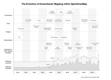
Figure 1 provides context and motivation for our research by showing a chronology of key events in humanitarian mapping since 2010, the year HOT was founded in the aftermath of the devastating earthquake in Haiti. It shows the immediate impact that post-disaster community “activations” have had on the contributions to OSM. Besides these punctual events, there are several additional factors with more long-term effects such as the introduction of new tools, the availability of open satellite imagery for mapping in OSM and the number of organizations involved. Furthermore, political frameworks set the policy agenda and form the institutional space in which local communities, national and international NGOs operate.
Figure 1: Sketch of the evolution of humanitarian mapping in OSM in regard to major disaster activations, the socio-technical development of the community and global political frameworks. The plots at the bottom show the number of buildings and highways added to OSM.
The spatio-temporal statistical analysis of OSM’s full history since 2008 showed that humanitarian mapping efforts added 60.5 million buildings and 4.5 million roads to the map. Overall, mapping in OSM was strongly biased towards regions with very high Human Development Index. However, humanitarian mapping efforts had a different footprint, predominantly focused on regions with medium and low human development. Despite these efforts, regions with low and medium human development only accounted for 28% of the buildings and 16% of the roads mapped in OSM although they were home to 46% of the global population. Our results highlight the formidable impact of humanitarian mapping efforts such as post-disaster mapping campaigns to improve the spatial coverage of existing open geographic data and maps, but they also reveal the need to address the remaining stark data inequalities, which vary significantly across countries.
We furthermore analyzed OSM contributions on the national and sub-national level to statistically check which factors have been driving and prohibiting mapping activity. This has been complemented by an investigation of the temporal evolution of humanitarian mapping activity in OSM. For further details please refer to the paper in Scientific Reports by Nature, which also provides a more comprehensive discussion of the results and the methodology applied.
Figure 2: Spatial distribution of the number of (a)-(b) buildings and (c)-(d) highways added to OSM between 2008/01/01 – 2020/05/20 in regard to overall and humanitarian mapping activities. Further the maps depict the spatial distribution of (e) SHDI and (f) population density.
Please note that our insights about humanitarian mapping in OSM only provide an incomplete picture which lacks an on-the-ground perspective and neglects other remote mapping tools, since we considered only the mapping that was organized through the HOT Tasking Manager. For instance, humanitarian mapping that has been organized by local residents on the ground is not considered here. This limitation is accompanied by the fact that our analysis only focused on two types of mapped objects (buildings, highways). Mapping in OSM comes with a much greater variety of potential map objects (e.g. health facilities, schools, water points), which can add particular value in comparison to other geographic data sets. We are aware of the fact that our definition of humanitarian mapping is therefore oversimplified and the results must be taken with a grain of salt. In many regions of the world there is no clear distinctive line between humanitarian and non-humanitarian mapping activities as the humanitarian and non-humanitarian OSM communities are not disjoint.
Further Work
More statistics to monitor humanitarian mapping can be found at the Humanitarian OSM Stats webpage and in this blogpost series.
Herfort, B.; Li, H.; Fendrich, S.; Lautenbach, S.; Zipf, A. Mapping Human Settlements with Higher Accuracy and Less Volunteer Efforts by Combining Crowdsourcing and Deep Learning. Remote Sens. 2019, 11, 1799.
Raifer, M.; Troilo, R.; Kowatsch, F.; Auer, M.; Loos, L.; Marx, S.; Przybill, K.; Fendrich, S.; Mocnik, F.; Zipf, A (2019): OSHDB: a framework for spatio-temporal analysis of OpenStreetMap history data. Open Geospatial Data, Software and Standards. 4, 3.
Auer, M.; Eckle, M.; Fendrich, S.; Griesbaum, L.; Kowatsch, F.; Marx, S.; Raifer, M.; Schott, M.; Troilo, R.; Zipf, A. (2018): Towards Using the Potential of OpenStreetMap History for Disaster Activation Monitoring. ISCRAM 2018. Rochester. NY. US.
Auer, M.; Eckle, M.; Fendrich, S.; Kowatsch, F.; Marx, S.; Raifer, M.; Schott, M.; Troilo, R.; Zipf, A. (2018): Comprehensive OpenStreetMap History Data Analyses- for and with the OSM community. Talk at the State of the Map conference 2018, Milan.
Raifer, M. (2017): OSM history analysis using big data technology. Talk at the State of the Map conference 2017, Aizuwakamatsu.

