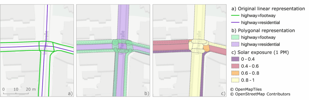
Using Heidelberg as a case study, researchers modeled time-dependent solar exposure for the entire pedestrian network by combining high-resolution DEM/DSM building and vegetation data with OpenStreetMap road data.
Adapting to heat stress in cities is a major challenge under global warming, as both climate change and the urban heat island effect increase health risks worldwide. This impact is uneven across regions and populations. Vulnerable groups such as the elderly, children, pregnant women, and those with chronic conditions tend to be more affected by the heat stress. Urban factors like building density, limited green space, and poor shading amplify exposure, particularly in deprived areas where air pollution may further worsen health effects.
While many heat adaptation measures target buildings and public spaces, less attention has been paid to how people move through cities during heat waves. Walking and cycling remain important transport modes in European cities, meaning residents may face excess sun exposure. Shade-optimized pedestrian routing has shown promise at neighborhood scale, but city-wide potential, trade-offs, and planning implications remain underexplored.
This research uses Heidelberg as a case study to evaluate the potential of city-wide, insolation-avoiding pedestrian routing. Two research questions guided the analysis: (1) To what extent can solar exposure be reduced through optimized route planning, and how does the trade-off between route length and exposure vary throughout the day? (2) Which parts of the road network positively or negatively impact pedestrian mobility depending on solar exposure and the availability of shaded routes?
High-resolution building and vegetation data, including a Digital Elevation Model (DEM) and Digital Surface Model (DSM), were obtained from the State Office for Geoinformation and Rural Development of Baden-Württemberg. The pedestrian network was extracted from OpenStreetMap (OSM). These datasets were combined to model time-dependent solar exposure for all pedestrian paths at four times of the day.
Solar exposure data were integrated into a routing service capable of generating shade-optimized, time-specific pedestrian routes. Researchers simulated 10,000 pedestrian trips for each of the four times of day and compared them to the corresponding shortest-distance routes. Analyses were conducted both at the level of individual trips and across the entire road network to identify streets with unavoidable high exposure.
Results show that significant reductions in pedestrian heat exposure are possible with minimal detours, though some areas lack shaded alternatives. This dual perspective reveals where targeted shading interventions could have the greatest benefit. While data availability limits transferability, emerging global datasets may expand applicability. Integrating this approach with broader climate adaptation plans can support health protection, especially as German cities are now mandated to include heat adaptation in urban planning.
Shade-based routing can reduce pedestrian heat stress and guide urban planners in prioritizing shading measures. Although not a standalone solution, it complements other adaptation strategies, helping maintain mobility and well-being during heat waves. Future work will refine routing to include additional environmental and walkability factors, using transdisciplinary approaches to meet both citizen and planner needs.
HEAL app for Heidelberg: HEAL-Heat avoidance routing application based on OpenRouteService
More about the project: HEAL
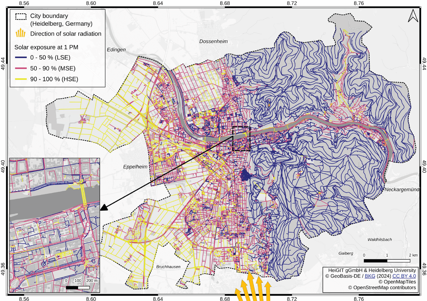
Title image: Map of Heidelberg showing the modeled solar exposure at 1 PM on July 9, 2023. Colors show low (purple), moderate (red), and high (yellow) solar exposure. The orange rays at the bottom of the figure depict the approximate direction of sunlight and the Sun’s position at that time. The Sun’s position was high in the sky with a solar zenith angle about 62.3◦ and a solar azimuth angle with respect to the north of around 164.7◦. The detail map shows eastern Bergheim, a central area west of the Old Town, and the detail of the modeled segment-level solar exposure. Solar exposure maps for the other times of day can be found appended as supporting information in Figures 12-14. The fuzzy dark spot south of the center is the municipal cemetery, which is almost fully covered by vegetation and offers many dense paths.
Reference: Kolaxidis, N., Ludwig, C., Knoblauch, S., Fürle, J., Foshag, K., Fendrich, S., Lautenbach, S., & Zipf, A. (2025). Mitigating heat stress by reducing solar exposure in pedestrian routing. Transactions in GIS. Advance online publication. Mitigating Heat Stress by Reducing Solar Exposure in Pedestrian Routing