Street-level imagery combined with deep learning methods is transforming how we detect and map critical infrastructure characteristics that are often missing from existing datasets. Applications range from road surface classification…
Humans rely on clean water for their health, well-being, and various socio-economic activities. During the past few years, the COVID-19 pandemic has been a constant reminder of about the importance…
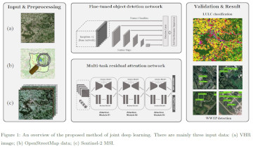
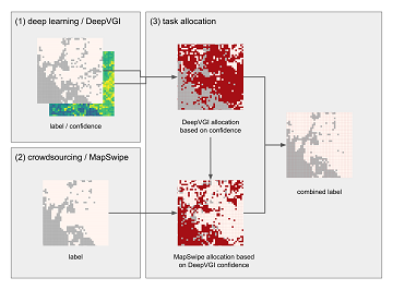
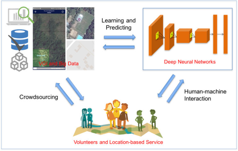
Large-scale mapping activities can benefit from the vastly increasing availability of earth observation (EO) data, especially when combined with volunteered geographical information (VGI) using machine learning (ML). High-resolution maps of…
The AGILE 2021 conference is taking place this week. It is the the 24rd AGILE conference on GIScience. AGILE is the Association of Geographic Information Laboratories in Europe and the…
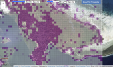
Accurate and complete geographic data of human settlement is crucial for humanitarian aid and disaster response. OpenStreetMap (OSM) can serve as a valuable source, especially for global south countries where…
Recently, a new research paper “Detecting OpenStreetMap missing buildings by transferring pre-trained deep neural networks” (Pisl, J., Li, H., Herfort, B., Lautenbach, S., Zipf, A. 2021) has been accepted at…
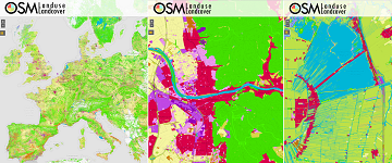
During the EuroSDR workshop we will present our OSMlanduse product (earlier post) to the land use (LU) and land cover community (LC) and highlight class accuracies and a benchmark comparison…
Am am 29.10.20, 16:30 Uhr veranstaltet das Netzwerk Geoinformation der Metropolregion Rhein-Neckar GeoNet.MRN zum Thema: Flächennutzung und Flächenmanagement: Ein Geoinformation Meetup Teilnahme: Kostenlos und ohne Anmeldung mit Teams unter diesem…
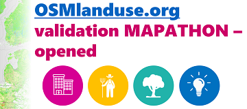
We launched a validation campaign of our new 10meter resolution OSMlanduse product for the member states of the European Union. Please contribute to the validation here. A technique where contributions…
We are pleased that our article has been selected by the editors of ISPRS Journal of Photogrammetry and Remote Sensing as the featured Article in August 2020. This means it…
After more than a decade of rapid development of volunteered geographic information (VGI), VGI has already become one of the most important research topics in the GIScience community. Almost in…
Accurate and detailed geographical information digitizing human activity patterns plays an essential role in response to natural disasters. Volunteered geographical information, in particular OpenStreetMap (OSM), shows great potential in providing…
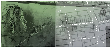
We are pleased to share that because of the response to our work, ISPRS IJGI selected our paper on Detecting Graffiti with Street View Images and Deep Learning to be…
The Center for Spatial Studies, Department of Geography at the University of California, Santa Barbara is hosting the Spatial Data Science Symposium 2019 this coming week with the title “Setting…
Our new paper on Machine Learning and Humanitarian Mapping Nowadays, Machine Learning and Deep Learning approaches are steadily gaining popularity within the humanitarian (mapping) community. New tools such as the…
Humanitarian organizations can’t help people if they can’t find them. This was the simple reason to create MapSwipe back in 2016 and it is still as pressing as in the…
Satellite images are widely applied in humanitarian mapping which labels buildings, roads and so on for humanitarian aid and economic development. However, the labeling now is mostly done by volunteers….
Recently, deep learning has been widely applied in pattern recognition with satellite images. Deep learning techniques like Convolutional Neural Network and Deep Belief Network have shown outstanding performance in detecting…