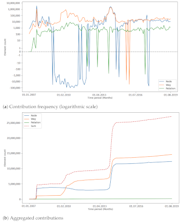
Am 02.11.2022 haben wir 10,107,826,483* Objekte in unserem oshdb erreicht. Das ist definitiv ein Grund zum Feiern! *Für Informationen über die Hintergrundfigur lesen Sie unser Basic guide to OSM data…
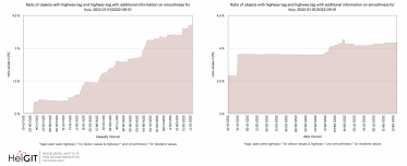
Willkommen zurück zu unserer ohsome Region des Monats-Serie! In diesem Post werden wir uns die zeitliche Entwicklung von Highways und hinzugefügten smoothness-information, sowie soziale Einrichtungen und neue Kartierungsentwicklungen in Kyiv…
Wir haben aufregende Neuigkeiten! Wie viele von Ihnen wissen, erfolgten die OSHDB-Updates in der Vergangenheit wöchentlich und führten zu einer Verzögerung zwischen den Daten in OpenStreetMap (OSM) und unserer Datenbank….
Das HeiGIT-Team hatte eine tolle Zeit auf der State of the Map 2022 in Florenz. Vielen Dank an die Teilnehmer für die fruchtbaren Diskussionen bei unserem Workshop! Trotz der direkten…
Endlich zurück! Willkommen zu einem weiteren Teil unserer Wie man ohsome wird-Serie! Dieser Beitrag ist besonders, da wir die Anwendung eines Drittanbieters diskutieren, die von der ohsome API als Back-End…
Willkommen zurück zu einem neuen Teil der Blogserie ohsome Region des Monats! Dies wird Teil zwei unserer Posts zu Tags im Zusammenhang mit Wanderungen sein, und dieses Mal werden wir…
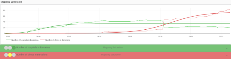
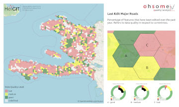
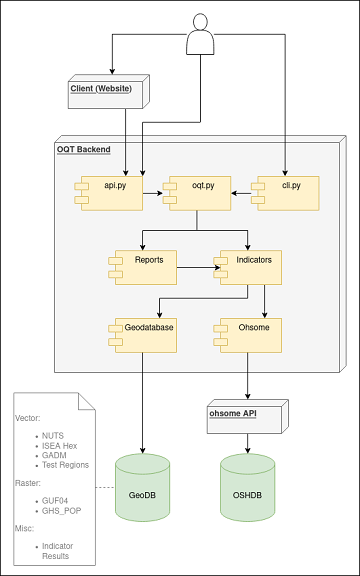
Seit der Veröffentlichung des ohsome Quality Analyst (Short OQT) im Februar letzten Jahres haben wir an der Entwicklung eines leicht zugänglichen, aber leistungsstarken Toolkits gearbeitet, das Endbenutzern Einblicke in die…
Hello and welcome back to the How to become ohsome-blog series! We hope the new year started off well for you! If you’re new to the series, you should read…
Welcome back to our blog post series How to become ohsome, where you get short and simple explanations on how you can become ohsome yourself! This time, it’s all about…
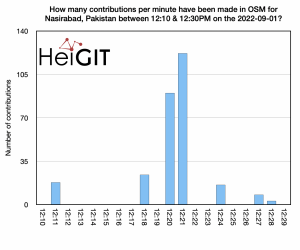
Hello and welcome back to another blog post of the ohsome Region of the Month series where you can learn about potential use cases of the ohsome API. This month…
Last week, the annual conference FOSS4G (Free and Open Source Software for Geospatial) has been taken place online. The conference is organized by The Open Source Geospatial Foundation (OSGeo) and…
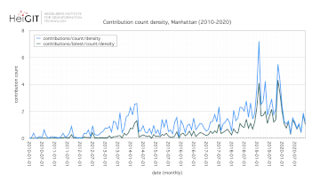
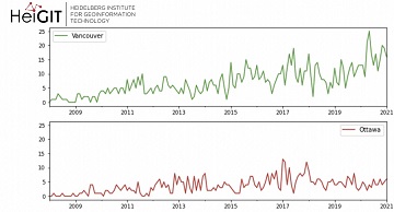
Hello and welcome back to the ohsome Region of the Month-blog post series where you can read about potential use cases of the ohsome API and maybe even get inspired…
OpenStreetMap (OSM) is a global mapping project which generates free geographical information through a community of volunteers. OSM is used in a variety of applications and for research purposes. However,…
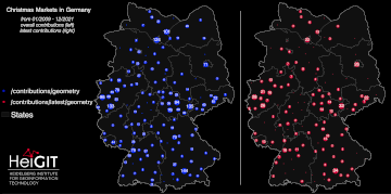
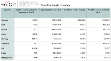
The ohsome region of the month blog post series is back and since it’s summer this time we’re taking you to the coast. Before that happens, if this is your…
The ohsome quality analyst (short: OQT) has been introduced at the beginning of this year and today we are proud to announce two updates. First, we released the new version…
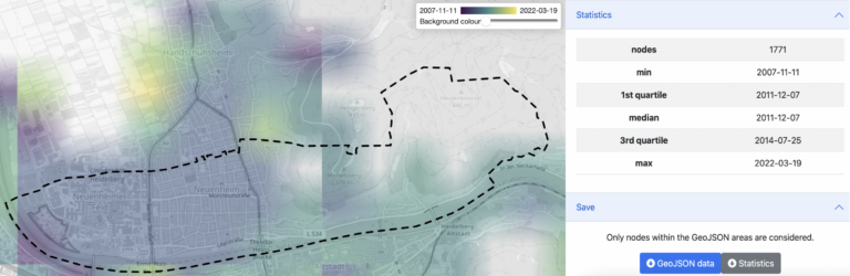
Did you ever wonder how your city was mapped over time, how geometries were changed and refined, how mistakes were added and corrected again? Then read on: ohsomeHex has a…
Welcome back to our blog post series ”ohsome Region of the Month” where you can find information on potential applications of the ohsome API. If you’re new to this format…
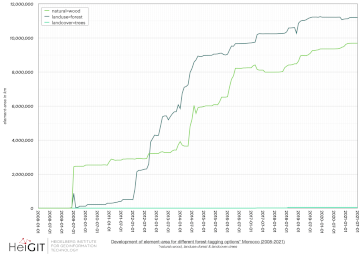
Welcome back to the ohsome region of the month format where you can learn and get inspiration about potential applications of the ohsome API. This time we looked at forest-related…
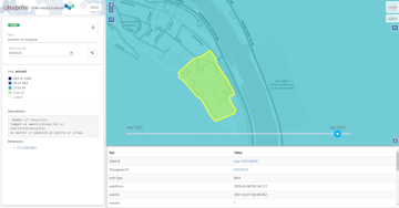
As a little Easter present, we published the first version of the ohsome-py Python package today. ohsome-py helps you extract and analyse OpenStreetMap history data using the ohsome API and…
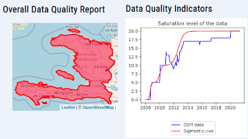
The #ohsome quality analyst (short: OQT) has been online and accessible through its web-interface now for quite some weeks already (see the introductory blog post as a reference). The website…