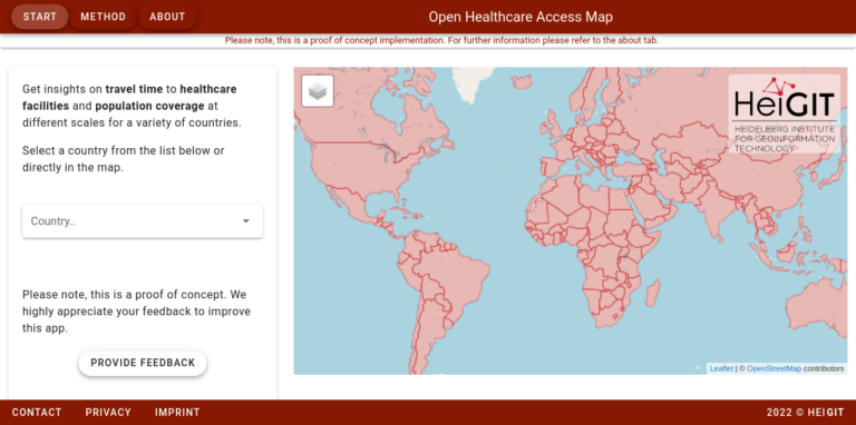
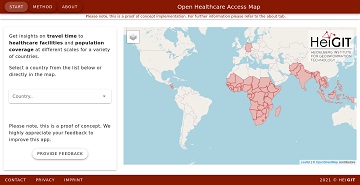
Im vergangenen Jahr haben wir die Open Healthcare Access Map gestartet. Zunächst waren nur einige Länder und später Kontinente verfügbar. Wir freuen uns heute anzukündigen, dass wir die restlichen,…
UPDATE 09.11.2022: Unser Team hat an der State of the Map 2022 Tagung in Florenz, die neuerdings wieder in-Person stattfindet, teilgenommen. Wir haben bei Workshops mitgemacht, Vorträge angehört und hatten…
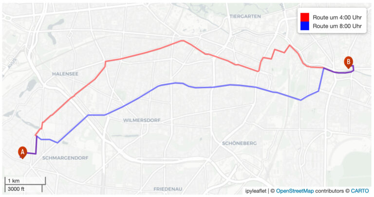
Heidelberger Geoinformatiker*innen machen im Projekt „SocialMedia2Traffic“ geokodierte Informationen nutzbar. Heidelberg 23.05.2022. Navigationsdienste benötigen aktuelle Verkehrsinformationen, um geeignete Routen zu ermitteln und die Fahrzeit möglichst genau zu berechnen. Dafür können nun…
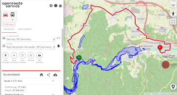
Unterführungen, Treppen und hohe Bordsteinkanten sind für Menschen mit Gehbeeinträchtigungen eine große Herausforderung. Ein maßgeschneiderter Routenplaner kann aber ihre Mobilität erhöhen, indem er Wege mit möglichst wenigen Hindernissen berechnet. Dieses…
In the context of the United Nations World Data Forum 2021 organised by theUnited Nations Statistics Division and UN member states a series of blogposts has been published by UNSTATS….
Under pressure from the decision of the Federal Constitutional Court in spring 2021, the German government has amended its climate targets. The new coalition also wants to stick to these…
Aktuelle Meldung der Universität Heidelberg zum Projekt HEAL: https://www.uni-heidelberg.de/de/newsroom/wenn-es-in-der-stadt-zu-heiss-wird BADEN-WÜRTTEMBERG STIFTUNG FÖRDERT HEIDELBERGER PROJEKT ZU ROUTINGDIENST MIT HITZEVERMEIDENDEN WEGSTRECKEN Wo in der Stadt Heidelberg ist es besonders heiß und wie…
The “11th International Conference on GIScience” 2021 started! Our full paper related to MeinGrün project and openrouteservice will be presented this Tuesday 13:30 CET in Session 3 “Mobility”: 13:30-13:45: Christina…
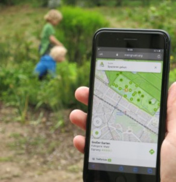
Urban green spaces (UGSs) can provide important ecosystem services for citizens and their well-being. To make use of these services according to UGS user demands, urban residents, tourists, and city…
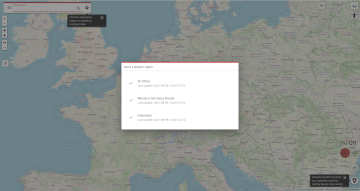
We are happy to announce a revamped openrouteservice maps client for disaster management. It was built based on the new openrouteservice maps client, that is an open source route planner…
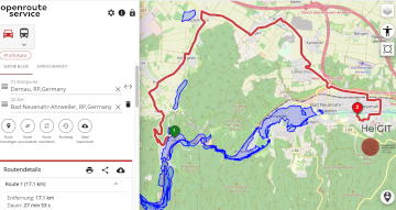
Die aktuelle Flut in Deutschland hat zahlreiche Straßen in den betroffenen Gebieten zerstört oder temporär unpassierbar gemacht. HeiGIT arbeitet an freien und offenen, auf Geodaten-basierten Lösungen für die humanitäre Hilfe….
Im Rahmen einer transdisziplinären Zusammenarbeit entwickeln das Heidelberg Institute for Geoinformation Technology (HeiGIT), die GIScience Forschungsgruppe sowie das TdLab Geographie der Universität Heidelberg gemeinsam Anpassungsstrategien, die Risikogruppen während Hitzeperioden unterstützen…
Openrouteservice für komplexe Routenoptimierung in neuer QGIS-Erweiterung des Regionalverband Ruhr Der Regionalverband Ruhr (Team 9-2 Geodaten-Technik) hat mit einer neuen QGIS-Erweiterung das Potenzial von openrouteservice (ORS) von HeiGIT genutzt und…
The AGILE 2021 conference is taking place this week. It is the the 24rd AGILE conference on GIScience. AGILE is the Association of Geographic Information Laboratories in Europe and the…
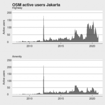
Data quality is an important issue then performing analysis based on OpenStreetMap data. We have recently demonstrated how the effects of the 2013 flood in Jakarta on the accessibility of…
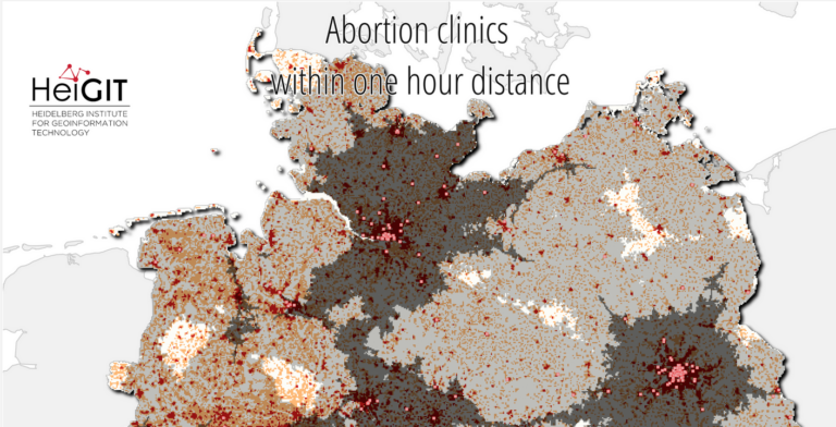
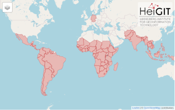
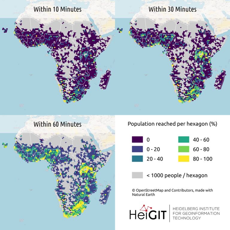
After Sub-Saharan Africa and South and Southeast Asia we have now published all countries of Central and South America on the Open Healthcare Access Map. The web application is available…
Seit kurzem nutzt die Stadt Mannheim openrouteservice (ORS) von HeiGIT für das Routing von Fußgängern, Fahrräder, Autos, LKW und Rollstuhlfahrern im Online-Stadtplan für die breite Öffentlichkeit, d.h. die Bürger und…
It’s been a little longer than a month since we published the Open Healthcare Access Map. Last week we rolled out all countries of Sub-Saharan Africa. Today all countries of…
Last month we started the Open Healthcare Access Map. Initially, only a few countries were featured. Gradually, more countries and regions are now being added. Today we release all countries…
Up-to-date traffic information is a prerequisite for navigation solutions to determine the best route and travel time. In the SocialMedia2Traffic project by HeiGIT and GIScience Heidelberg , conclusions about current…