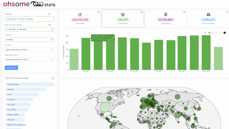
Our new ohsome dashboard is another preview on what is and will be possible with our ohsome OpenStreetMap history analytics platform. Behind the scenes, we added support for the Apache Ignite big data framework and deployed an instance using the full OSM history data of whole Germany on Heidelberg University’s cloud computing infrastructure heiCLOUD. Apache Ignite is an open-source distributed database, caching and processing platform designed to store and compute on large volumes of data across a cluster of nodes. This enables larger and faster queries, e.g. the processing of common requests like counting buildings of a larger city at a monthly time resolution is typically performed in less than one second and even only takes just a few seconds for a whole country.
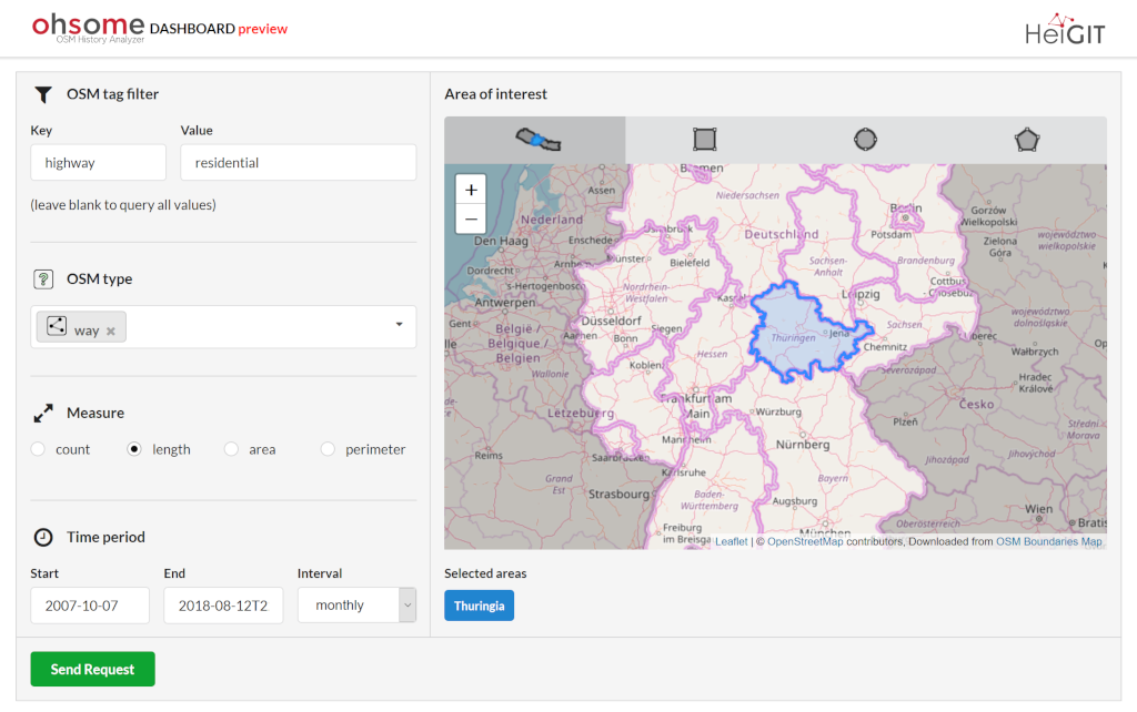
The dashboard using Germany as example data is based on the Nepal dashboard, but includes more functionality: It is more generic and flexible as it allows custom filtering of all available OSM tags and types, not only buildings or roads. The dashboard now includes administrative boundaries from states down to city-level, which enable one to make an easier selection of relevant search areas. Using the dashboard, generating accurate statistics about the historical development of OSM data for an arbitrary region it is now as easy as pie:


As you may know, the idea of the ohsome platform is to enable intrinsic quality analytics and understand the development of OSM through time and space for both, researchers, as well as the OSM community. We are looking forward to hear your feedback and ideas for improvement. Please feel free to contact us with your comments or to contribute to the open source development. Future work will focus on enlarging the supported region towards a global scale, as well as adding further functionality.
Previous ohsome architecture blog posts:
- introduction of the ohsome data analysis platform
- high level architectural overview
- OSHDB: ohsome’s data processing backbone
- ohsome api: introduction
- Documentation of the ohsome API
Selected Literature:
- Auer, M.; Eckle, M.; Fendrich, S.; Griesbaum, L.; Kowatsch, F.; Marx, S.; Raifer, M.; Schott, M.; Troilo, R.; Zipf, A. (2018): Towards Using the Potential of OpenStreetMap History for Disaster Activation Monitoring. ISCRAM 2018. Rochester. NY. US.
- Auer, M.; Eckle, M.; Fendrich, S.; Loos, L.; Kowatsch, F.; Marx, S.; Raifer, M.; Schott, M.; Troilo, R.; Zipf, A. (2018): Eine Plattform zur Analyse raumzeitlicher Entwicklungen von OpenStreetMap-Daten für intrinsische Qualitätsbewertungen. AGIT Symposium, Salzburg, Austria.