Volume 26, Ausgabe 8 von Transactions in GIS, die im Dezember 2022 erschien, hat eine Titelgeschichte, und zwar einen unserer Artikel. Wir wollen darin nicht nur unsere Liebe zur Mathematik,…
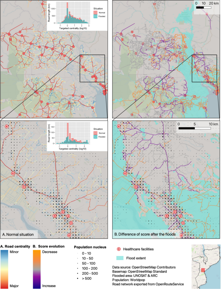
Gezeigtes Bild: Straßennetzwerkanalyse für die Fahrprofile. A Normale Verhältnisse vor dem Flutereignis. B Entwicklung des Scores nach den Überschwemmungen durch den Zyklon Idai. Die untere Reihe zeigt eine Nahaufnahme des…
In the context of the United Nations World Data Forum 2021 organised by theUnited Nations Statistics Division and UN member states a series of blogposts has been published by UNSTATS….
Recently videos with our contributions by HeiGIT to the FOSS4G conference were put online. Did you miss the event? Now you can watch whenever you like 🙂 Benni by HeiGIT…
MapSwipe has ben announced as ‘App of the Day‘ in the Apple AppStore! (27.08.2021) Thank you to all our volunteers for the continued help and support which keeps the app…
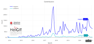
The project “25 Mapathons“ goes into the next phase. Based on the experience of until today 17 OSM mapathons with German Red Cross (GRC) chapter and an extensive literature review…
Gemeinsam mit dem Deutschen Roten Kreuz (DRK) hat das HeiGIT heute das Dokument “Die häufigsten Fehler beim „mappen“ mit dem iD-Editor & deren Lösung” veröffentlicht. Das Dokument ist komplementär zum…
Hello dear friends of the disastermappers heidelberg! At the moment, the Heidelberg International Weeks against Racism 2021 are running – and the disastermappers are also taking part! Why? The unequal…
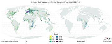
Since 2010 organized humanitarian mapping has evolved as a constant and growing element of the global OpenStreetMap (OSM) community. With more than 8,000 projects in 150 countries humanitarian mapping has…
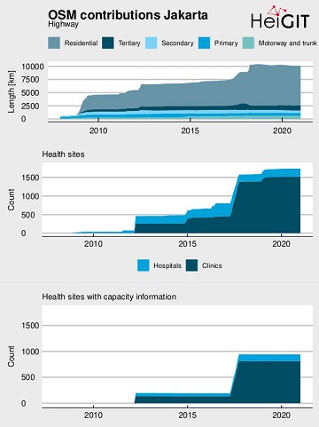
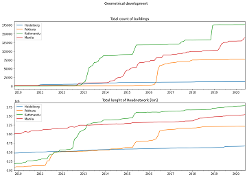
Extreme natural events create catastrophic situations for cities and their populations. Due to climate change and anthropogenic activities, the number and intensity of these events has steadily increased at the…
Since 2010, organized humanitarian mapping has evolved as a constant and growing element of the global OpenStreetMap (OSM) community. With more than 7,000 projects in 150 countries, humanitarian mapping has…
Das Handbuch zur Veranstaltung von Mapathons im Deutschen Roten Kreuz (DRK) ist da! In dem Handbuch wird beschrieben, was bei der Durchführung eines Mapathon zu beachten ist. Es beginnt mit…
On 8th November 2020, the Anticipation Hub has been officially launched and we are happy to announce that the Heidelberg Institute for Geoinformation Technology (HeiGIT gGmbH) acts as as a…
Next week the HOT Summit will take place. The conference takes already place for the sixth time and it is the fifth consecutive time that we from HeiGIT/GIScience Heidelberg do…
“Local Knowledge” is constituting the exceptional value of Volunteered Geographical Information and thus also considered as an important indicator of data quality. We are interested in how much local information…
The project “25 Mapathons” made an important step forward by successfully completing the first four Mapathons of the project. Two Mapathons were conducted with German Red Cross (GRC) members from…
CALL FOR PAPERS – 18th International Conference on Information Systems for Crisis Response and Management (ISCRAM 2021) May 23-26, 2021, Virginia, USA – https://www.drrm.fralinlifesci.vt.edu/iscram2021/ Virginia Tech Track: Geospatial Technologies and…
This Thursday, team members from HeiGIT will give a presentation at MSF’s Annual GIS Week. This is an internal event at MSF ( Médecins Sans Frontières (MSF) International, Doctors without…
HeiGIT unterstützt Workshops zu OpenStreetMap und humanitärem Mapping auf der AGIT 2020 In dieser Woche findet die jährliche AGIT-Konferenz und das parallele GI Forum statt. Während die Konferenz bereits seit…
In scope of the disastermappers heidelberg mapathon series “Open Data & the Sustainable Development Goals”, the next virtual OpenStreetMap mapping event “Mapping Human Rights” will take place on Tuesday, June…