As a little Easter present, we published the first version of the ohsome-py Python package today. ohsome-py helps you extract and analyse OpenStreetMap history data using the ohsome API and…
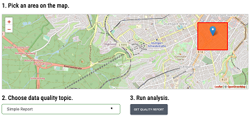
The #ohsome quality analyst (short: OQT) has been online and accessible through its web-interface now for quite some weeks already (see the introductory blog post as a reference). The website…
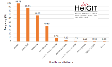
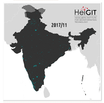
Last November, we covered the recent increase of healthcare related objects in OpenStreetMap (OSM) in India. In less than a year, the amount of facilities has increased from 6.956 to…
Extreme natural events create catastrophic situations for cities and their populations. Due to climate change and anthropogenic activities, the number and intensity of these events has steadily increased at the…
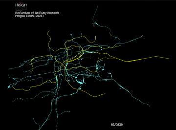
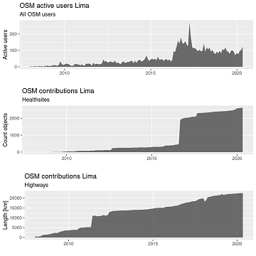
Welcome back to another #ohsome blog post written by our awesome student assistent Sarah! This time we will look at the completeness of railway network data of one specific city…
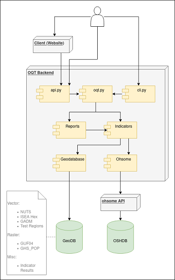
The Ohsome Quality analysT (short OQT) is the name of a new software implemented by HeiGIT that is based on the #ohsome framework. Its main purpose is to compute quality…
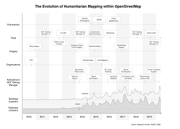
In the past 10 years, the collaborative maps of OpenStreetMap (OSM) have been used to support humanitarian efforts around the world as well as to fill important data gaps for…
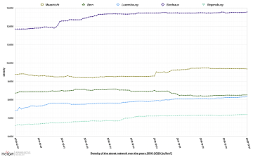
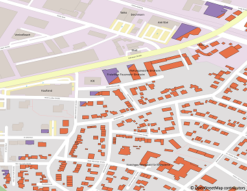
Welcome to part 2 of the #ohsome street network analysis. If you haven’t read the first part yet, you can do so following this link. As promised, this week we…
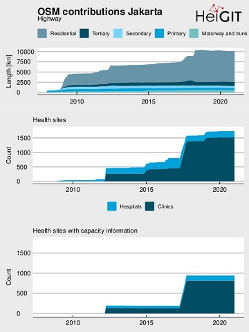
OpenStreetMap (OSM) offers many possibilities and holds potential in the area of freely available infrastructure data for the health sector. Nevertheless, it is important to underline that the quality of…
Here we go again: The first #ohsome blog post of 2021. This time, one of our new student assistants Sarah was dealing with street networks and their quality in order…
Current lockdown regulations in Germany state that – in many but not all federal states – travel in COVID-19 hotspot regions is only allowed up to 15km distance. This has…
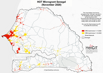
What is the idea behind the Notebook? In the case of an emergency (e.g. floods, earthquakes, political crisis) it is important to know where the health facilities are located. Furthermore,…
India accounts for nearly 18% of the worlds population. The country is also one of the main carrier of the worlds disease burden. Despite the general increase in life expectancy…
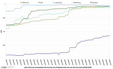
“Local Knowledge” is constituting the exceptional value of Volunteered Geographical Information and thus also considered as an important indicator of data quality. We are interested in how much local information…
Erhalten Sie mit ohsomeHeX wertvolle Einblicke in die Qualität und den Entwicklungsprozess von OpenStreetMap-Daten! (see for english version here) Das HeiGIT Big Data Team freut sich zur Exploration der Veränderungen…
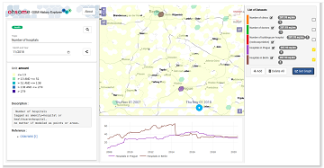
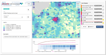
Get valuable insights into the quality and development process of OpenStreetMap data with ohsomeHeX! We are proud to announce a new release that provides a completely redesigned UI that makes…
The HeiKA autumn school urban data science that took place last week was a good success with participating students varying between five and fifteen during the week. Topics covered included…
This Thursday, team members from HeiGIT will give a presentation at MSF’s Annual GIS Week. This is an internal event at MSF ( Médecins Sans Frontières (MSF) International, Doctors without…
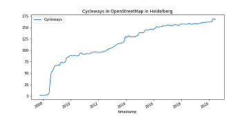
It’s CITY CYCLING time – some of you may even be involved in your municipality – a good opportunity to have a look on the OpenStreetMap (OSM) cycling ways in…
Recently we’ve had the first minor release 1.1 of the ohsome API, which brings several new features and upgrades. In the following lines we want to present to you the…