The open, flexible and collaborative nature as well as the benefits and advantages of OpenStreetMap (OSM) lead to the creation of a whole new ecosystem evolving around the project. They…
We are happy to share that our paper “A Comprehensive Framework for Intrinsic OpenStreetMap Quality Analysis” (Barron, Neis, Zipf 2013) belongs to the top 5 most cited papers of the…
#OpenStreetMap is turning 16! Happy Birthday from the HeiGIT team. 16 years of OSM activity has created the most feature rich and global free multi purpose map that the world…
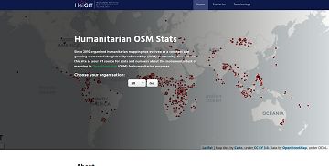
Since 2010 organized humanitarian mapping has evolved as a constant and growing element of the global OpenStreetMap (OSM) community. With more than 7,000 projects in 150 countries humanitarian mapping has…
As you may already know from the latest blog posts, new advancements are brought with the release 1.0 of the #ohsome API. One minor function involves the correctness of parameters…
After more than a decade of rapid development of volunteered geographic information (VGI), VGI has already become one of the most important research topics in the GIScience community. Almost in…
Vom 06. bis zum 08. Juli fand das Online Symposiums “COVID-19 als Zäsur? Geographische Perspektiven auf Räume, Gesellschaften und Technologien in der Pandemie” statt. Teilnehmer aus Geographie, Medizin, Public health…
Today (1st July 2020) marks the first birthday of HeiGIT gGmbH! Over this first year, HeiGIT has been involved a large number of events, projects, publications, and press coverage. Founded…
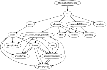
What does the tool behind the recently published documentation of the ohsome API have in common with a statue made of stones in Egypt? – Apart from the name, both…
The Humanitarian OpenStreetMap Team (HOT) has announced major financial support from the Audacious Project, which will be provided over the next five years. HOT aims to use this funding to…
Using hospital locations and the ORS Isochrone service, we have created a method for comparing physical access to healthcare in Sub-Saharan Africa. Hospital locations were derived from OpenStreetMap and compared…
As we’ve announced it in a previous post, the Open Source release 1.0 of the ohsome API has finally arrived. As a reminder, or for those of you that hear…
Big news from the ohsome team: the release 1.0 of one of our major services, the ohsome API for ohsome OpenStreetMap History Analytics, is on the doorstep. We are bringing…
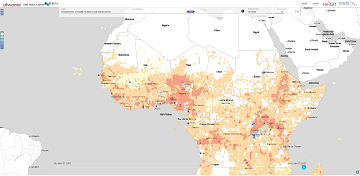
A new map in ohsomeHeX provides an overview of areas in Sub-Sahara Africa where information on health facilities is still missing in OpenStreetMap (OSM). The completeness of OSM is measured…
We are happy to invited to the presentation in the GIScience HD colloquium. Everybody interested is invited to join the presentations and the discussion afterwards. Building a baseline of health…
Recently the SOTM 2019 Heidelberg Academic Track Proceedings have been published. GIScience Research Group Heidelberg and HeiGIT contributed several talks and posters. Below you can find an overview. Contact us…
Around 55 participants gathered in Malta for the 3rd International Workshop on Spatial Data Quality 2020 from 28th to 29th of January. Among national mapping agencies, software providers and standardization…
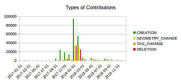
Humanitarian mapping activations show increasing numbers of contribution. This blog post illustrates the specific potential of the OSHDB API [1] for detailed analyses of such activations by means of a…