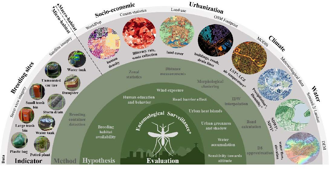
To improve vector control strategies, Dr. Steffen Knoblauch (PostDoc at GIScience and HeiGIT) has developed detailed maps showing where Aedes aegyti is most likely to thrive. Using a holistic approach, his work leverages geospatial big data – including openly available satellite and street view imagery as well as climate data – to identify common breeding habitats. This advancement fills a critical research gap by generating the first large-scale and spatially continuous mosquito distribution maps at the habitat level, supporting local intervention planning.
Controlling Aedes aegypti is the primary strategy for mitigating the global threat of vector-borne viral infections such as dengue fever, which causes approximately 400 million infections and 40,000 fatalities annually. Effective interventions require a precise understanding of Ae. aegypti spatiotemporal distribution and behavior, particularly in urban settings where most infections occur. However, conventional sample-based entomological surveillance systems often fail to capture the high spatial variability of Ae. aegypti due to heterogeneous urban landscapes and the mosquito’s limited flight range.
This study addresses this challenge by leveraging emerging geospatial big data, including openly available satellite and street view imagery, to identify common Ae. aegypti breeding habitats. This data enabled the inference of seasonal suitability for Ae. aegypti eggs and larvae at a spatial resolution of 200 meters within the municipality of Rio de Janeiro.
The proposed micro- and macro-habitat indicators for immature Ae. aegypti explained the distribution of Ae. aegypti ovitrap egg counts by up to 72% [95% CI 70–74] and larval counts by up to 74% [95% CI 72–76]. Spatiotemporal interpolations of ovitrap counts, utilizing suitability indicators, provided high-resolution insights into the spatial variability of urban immature Ae. aegypti that could not be captured with sample-based surveillance techniques alone.
The potential of this method lies in synergizing entomological field measurements with digital indicators of the urban landscape to guide vector control and address the spread of Ae. aegypti-transmitted viruses. Estimating Ae. aegypti distributions while considering habitat size is particularly important for targeting novel vector control interventions such as Wolbachia.
This research was funded by the German Research Foundation (DFG) and the Austrian Science Fund (FWF).
If you want to learn more about the spatio-temporal dynamics of emerging viruses, please visit the GeoEPI project page.
Image description: Grouped stack of self-generated urban suitability indicators for immature Ae. aegypti, featuring data sources, methods employed for retrieval, and formulated hypotheses for evaluation with entomological surveillance data. A more dense collection of proposed indicators with references for assumed hypotheses and data source is listed in the supplements. Indicators marked with an asterisk (*) represent spatiotemporal factors, while those without an asterisk (*) were considered to be temporally constant in our case study.
Reference: Knoblauch, S., Mukaratirwa, R. T., Pimenta, P. F. P., de A Rocha, A. A., Yin, M. S., Randhawa, S., Lautenbach, S., Wilder-Smith, A., Rocklöv, J., Brady, O. J., Biljecki, F., Dambach, P., Jänisch, T., Resch, B., Haddawy, P., Bärnighausen, T., & Zipf, A. (2025). Urban Aedes aegypti suitability indicators: a study in Rio de Janeiro, Brazil. The Lancet Planetary Health, 9(4), e264–e273. https://doi.org/10.1016/S2542-5196(25)00049-X