Reliable geodata is essential for informed decisions, such as preparing emergency supply chains, assessing road conditions, identifying healthcare gaps, or guiding climate investments. Yet in many regions, this information is often unavailable, difficult to locate, or challenging to use.
Below is a growing collection of HeiGIT datasets that support humanitarian action, infrastructure planning, and climate research. All datasets are open and free to use. The collection features the Climate Action Indicators dataset (Climate Action Navigator), Accessibility Indicators dataset (OpenAccessLens), Risk Assessment Indicators dataset, Planet Road Surface Data, and Road Surface Data from OpenStreetMap and Mapillary. These resources provide open geospatial data to support analysis, planning, and decision-making across different fields.
- Climate Action Indicators
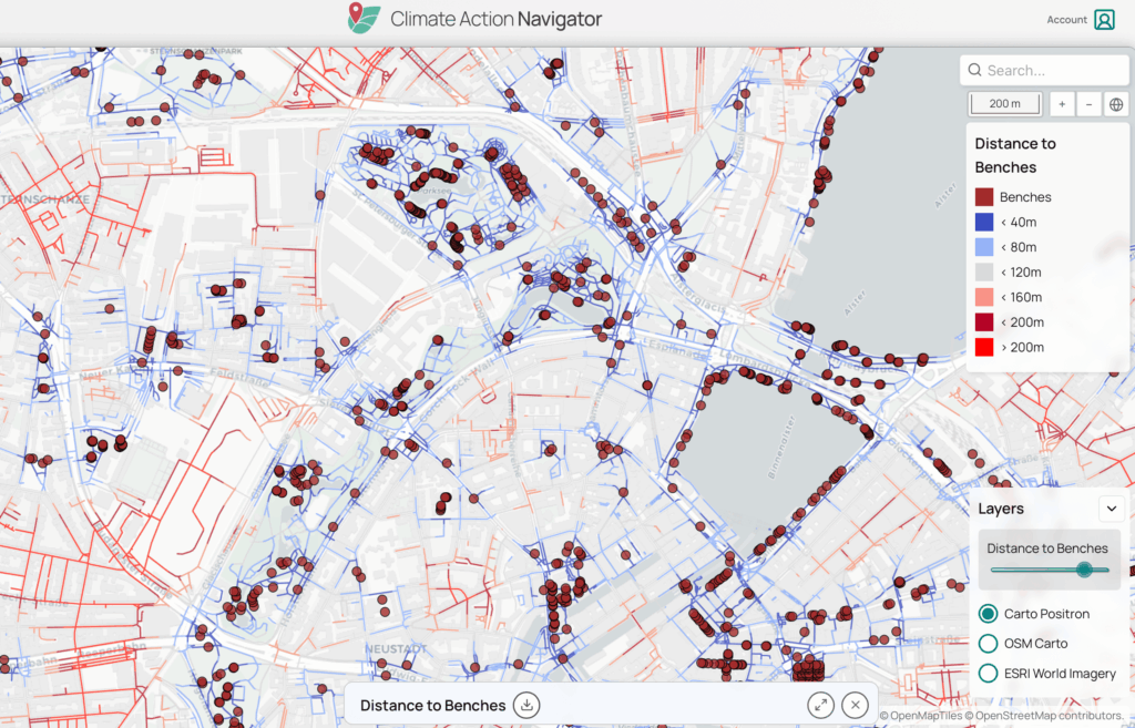
Climate Action Navigator (CAN) helps communities identify priority areas for climate action by transforming open geodata into clear, data-driven insights. Previously, these insights were accessible only through CAN’s assessment tools and visualizations.
The Climate Action Indicators dataset collection currently includes indicators covering:
- Walkability (hiWalk)
- Bikeability (hiBike)
- Residential heating emissions
- Land use / land cover change emissions
These indicators cover different aspects of local climate planning and action. The mobility indicators show how well neighborhoods support low-carbon transport like walking and cycling. The emissions indicators highlight where residential heating or land-use changes add to greenhouse gas emissions.
Providing these indicators as datasets expands their application beyond visualization. They can be integrated into GIS workflows, comparative analyses across cities or regions, and long-term monitoring, supporting public administrations and advocacy groups in establishing baselines, prioritizing interventions, and tracking progress. This dataset is available for download here.
- Accessibility Indicators
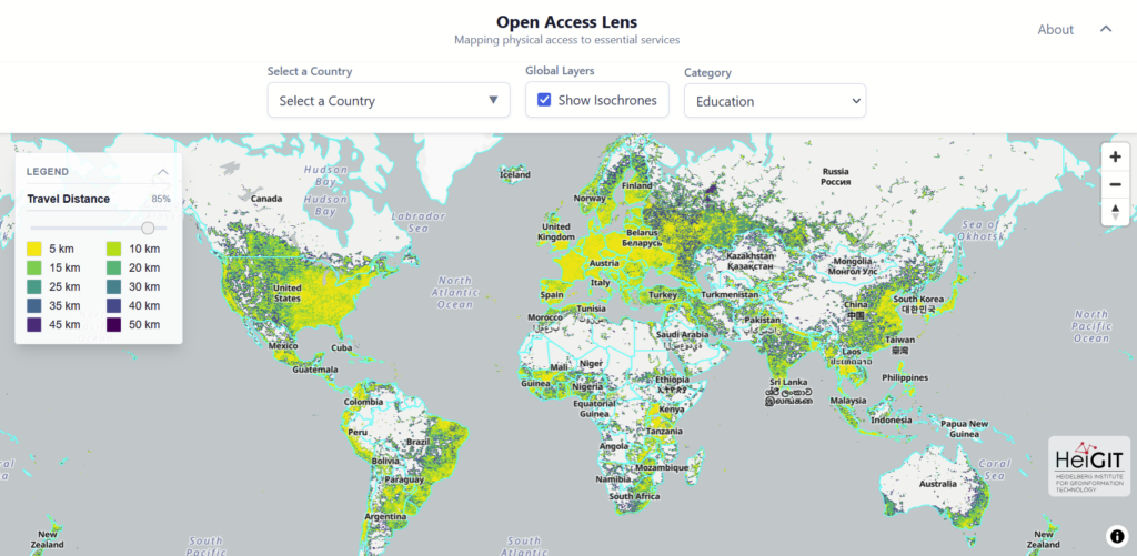
Access to healthcare and education is fundamental for resilience and social inclusion. HeiGIT’s Accessibility Indicators dataset, visualized through the OpenAccessLens platform, offers global estimates of spatial access to healthcare and education.
The dataset integrates travel-time isochrones from openrouteservice, based on OpenStreetMap road data, combined with WorldPop population data at 100-meter resolution. By intersecting accessibility with population distribution, it estimates the number of people within each interval. Results are aggregated by country and, where possible, also by administrative units.
The Accessibility Indicators dataset includes:
- Healthcare access measured in travel-time intervals (10–120 minutes to hospital services)
- Education access is measured in distance intervals (5–50 kilometers to schools)
Available through the Humanitarian Data Exchange (HDX). This dataset supports humanitarian assessments, public health research, and planning, especially for comparing access among regions.
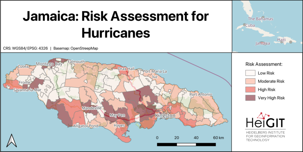
- Risk Assessment Indicators Dataset
Risk assessments are essential for anticipatory action and disaster preparedness. Yet, gathering consistent indicators for exposure, vulnerability, and coping capacity can take a lot of work. To support practitioners, HeiGIT’s Risk Assessment Indicators dataset provides a structured, easy-to-use baseline.
The dataset brings together indicators at administrative level 2, making it easier to compare regions. Its standard format supports risk assessments for different hazards and works with HeiGIT’s Risk Assessment QGIS Plugin.
The dataset includes the following:
- Baseline indicators for vulnerability
- Baseline indicators for coping capacity
- Hazard-specific exposure indicators, such as flood and cyclone exposure, where data is available
The dataset makes it easier to calculate risk assessments, allowing practitioners to focus on weighting indicators, incorporating local knowledge, and interpreting results.
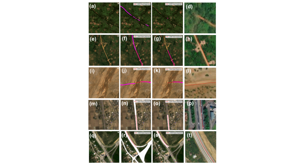
- PlanetScope Road Surface Data
Many global transport datasets lack complete road surface information, which is essential for routing, logistics, and infrastructure planning. To address this, HeiGIT released the Planet Road Surface Data, a satellite-derived dataset based on PlanetScope imagery from 2020 and 2024.
The dataset uses satellite images with a resolution of 3 to 4 meters and machine learning methods to study about 9.2 million kilometers of the global arterial road network. It covers arterial roads classified in OSM as motorway, trunk, primary, and secondary, including their link classes. This approach provides a consistent view of important road surface features.
The dataset includes the following information:
- Road surface type (paved / unpaved)
- Road width
- Changes in road surface, for example, roads that changed from unpaved to paved between 2020 and 2024
- A Humanitarian Passability Score, which combines information about surface type and road width.
The Humanitarian Passability Score helps to assess the accessibility of road networks for logistics and emergency planning. This dataset is freely available on the Humanitarian Data Exchange (HDX) and is intended to be updated annually. Besides routing, it can also be used to track infrastructure development and changes in road surfaces over time.
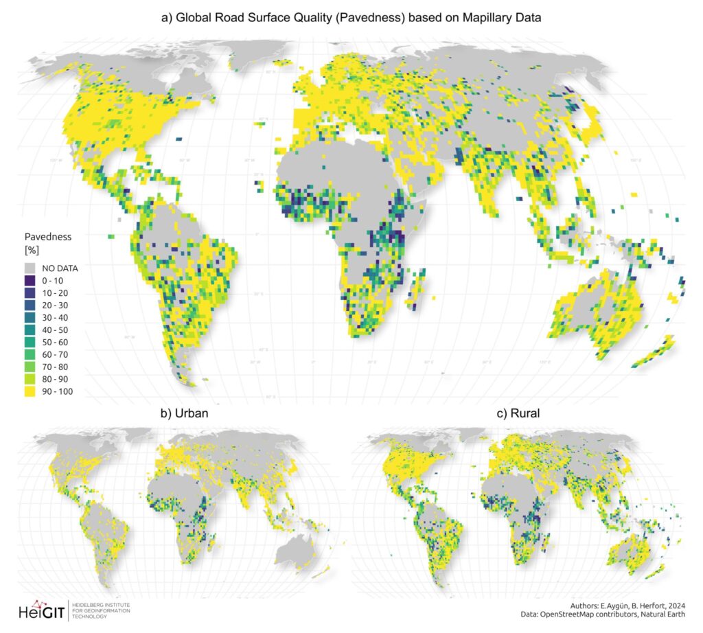
- Road Surface Data from OpenStreetMap and Mapillary
HeiGIT developed a road surface dataset using OpenStreetMap road geometries and Mapillary street-level imagery. The dataset applies machine learning to predict whether road segments are paved or unpaved.
While OpenStreetMap (OSM) is a fundamental data source for road information worldwide, surface data remains scarce in many regions. By using street-level imagery to infer surface type, the dataset expands the availability of road surface information beyond existing OSM tags.
The dataset provides:
- Predicted road surface type (paved / unpaved)
- Expanded coverage of surface information where OSM surface tags are missing
The dataset supports transportation analysis, routing, and infrastructure planning. Improving the availability of surface information enhances assessments of road reliability, safety, and accessibility, particularly in regions where unpaved roads can limit mobility. The dataset is available here. For more information on the dataset, read here.
These datasets demonstrate how open geoinformation translates directly into better decisions. A humanitarian logistics coordinator can use the Planet Road Surface Data and Passability Score to identify viable supply routes into flood-affected areas. A municipal planner can draw on the Climate Action Indicators to target cycling infrastructure investments where bikeability is lowest. A public health agency can use the Accessibility Indicators to pinpoint communities more than 60 minutes from the nearest hospital. Humanitarian workers can load the Risk Assessment Indicators directly into QGIS to build anticipatory action protocols, without spending weeks compiling baseline data.
As our dataset collection grows, we remain committed to open science principles. We ensure that geographic knowledge is generated, shared, and applied to achieve positive societal and environmental outcomes.