Integrating Geographical Knowledge into Artificial Intelligence
Project Phase: October 2024 until December 2025
Overview
AI models are increasingly effective in geographical applications, such as mapping roads, buildings, and land use from images. However, these models are purely data-driven, leading to energy-intensive training and occasional misclassifications. They also lack geographical knowledge—spatial relationships grounded in common sense, logic, scientific observations, and physical rules.
The project, a cooperation between GIScience and HeiGIT, aims to bridge this gap by integrating geographical knowledge into AI models for enhanced accuracy and efficiency.
Challange: Incorporating Geographical Knowledge
Unlike physics, where data can often be represented through deterministic equations, geographical knowledge cannot be fully vectorized. Real-world geographical objects, however, indirectly reflect this knowledge, as humans naturally act upon it. This becomes evident in AI-generated mapping data: while models may perform accurately in well-represented environments, they often produce errors in diverse or less familiar contexts due to a lack of true geographical understanding. Integrating geographical knowledge into AI models can reduce such errors, making mapping more reliable across diverse environments.
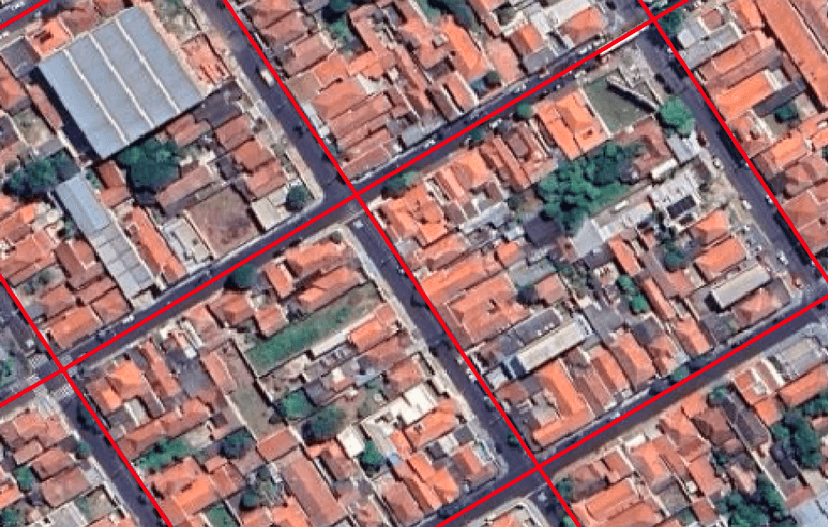
Example 1: Correct Mapping in Urban Areas
On the left, we see an example of accurate AI mapping in an urban setting. The structured layout of city roads is correctly interpreted by the AI model, demonstrating its effectiveness in areas with well-defined features.
AI-generated road data from Microsoft (2020) in an urban environment
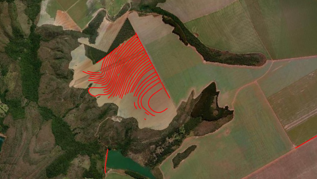
Example 2: Incorrect Mapping in Agricultural Landscapes
An image on the right showcases a notable error where AI misinterprets furrows in agricultural land as roads. This highlights the limitations of current AI models in understanding complex, unstructured landscapes.
AI-generated road data from Microsoft (2020) includes a notable example of erroneous image interpretation
Goals of the GeoWiKI Project
The primary objective of this project is to investigate how incorporating geographical knowledge into AI models can:
Reduce training time and energy consumption
Increase model accuracy and performance
Research Questions
1. Defining Geographical Knowledge
What constitutes geographical knowledge, and how can it be represented as vectorized data?
2. Integration Methods
What are effective ways to integrate geographical knowledge into AI models?
3. Impact on AI Models
How do these implementations affect the models’ efficiency and predictive performance?
Approach
Utilizing OpenStreetMap
We plan to use OpenStreetMap (OSM) as a database to extract and generalize geographical knowledge for AI models. As the world’s largest community-based Volunteered Geographic Information (VGI) mapping project, OSM’s open structure allows for broader application and generalization to various tasks.