Do we really need digital sovereignty—and why?
Today, over 80% of Europe’s digital products, services, infrastructures, and intellectual property originate from outside the EU. This dependency affects not only innovation capacity but also raises concerns about data governance, platform control, and long-term resilience.
Digital sovereignty refers not just to securing infrastructure or enforcing data protection laws. It’s about having the independent capability to build, maintain, and trust the digital tools we rely on every day. It’s about ensuring that critical technologies reflect European values, remain accessible under open conditions, and can be adapted to local needs without relying on external gatekeepers.
Examples of this are already emerging: open-source platforms, European cloud initiatives, and decentralized data spaces are gaining momentum. At HeiGIT, we contribute to this landscape by developing open source technologies and research.
Open-source solutions for mobility
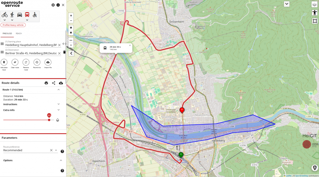
One example is openrouteservice (ORS) — a platform for routing and mobility analysis built on OpenStreetMap data. Starting as a small research project of the GIScience Group at the University of Heidelberg around 2008, ORS has been steadily growing and expending its functionalities. With over a decade of development and more than 150,000 users worldwide, ORS has been established as a reliable and maintained tool in the field of open-source, OSM-based routing technologies.
openrouteservice now offers a broad portfolio of services—from standard routing and isochrones to the analysis of mobility patterns and support for humanitarian logistics. The platform is designed as a modular ecosystem of tools and APIs, adaptable to diverse projects and user needs, whether self-hosted or accessed through HeiGIT’s infrastructure.
At its core, ORS enables routing for a variety of transport modes, including cars, bicycles, pedestrians and heavy vehicles. It integrates isochrone calculations, useful for identifying areas accessible within specific time or distance ranges—often applied in spatial planning, health service coverage analysis, or emergency response. The platform also provides distance and duration matrices, essential in logistics. Vehicle optimization features further support fleet management and service delivery scenarios with multiple destinations and constraints. Geocoding allows seamless conversion between addresses and geographic coordinates, enabling integration into broader geospatial workflows.
Example of Isochrones in Heidelberg
HeiGIT strives to support the community by providing innovative tools and services that benefit both the general public in their everyday lives and first responders in critical situations. Through projects that enhance disaster management and promote environmentally conscious routing, we aim to empower users with reliable and personalized navigation solutions.
To accommodate different institutional needs, ORS can be fully self-hosted, offering data privacy and autonomy. Alternatively, users can access hosted services operated by HeiGIT, ensuring compliance with European data protection standards. Free collaborative plans are available for humanitarian, academic, governmental, or non-for-profit organizations.
Developers and analysts can integrate ORS into their workflows using client libraries and interfaces in Python, JavaScript, R and via a QGIS plugin. All services are accessible via REST APIs, with extensive documentation. A growing community of contributors and users continues to support and evolve the project, reinforcing its transparency, adaptability, and long-term sustainability.
With our work, we aim to contribute to a more just and informed society—where access to geoinformation and geospatial technologies is open, transparent, and aligned with democratic values. Through platforms like ORS, we help build the foundations for resilient and sovereign digital technology.
If you have a business or research related inquiries feel free to contact us via support[at]smartmobility.heigit.org
Additional links:
GitHub – GIScience/openrouteservice: 🌍 The open source route planner api with plenty of features.