The role of land use changes in generating CO2 emissions is a crucial aspect in the fight against climate change. These emissions are the second-largest source of anthropogenic greenhouse gases, following energy production and usage. Given the urgent need to meet climate targets, especially the goal of achieving climate neutrality by 2040, detailed quantification of these emissions is vital. This was the focus of the Dresden Land Use Symposium 2024, where Veit Ulrich presented his research findings.
Significance of Emissions from Land Use Changes
Land and forestry, as well as changes in land use, significantly contribute to global CO2 emissions. When forests are cleared and converted into urban or agricultural land, the carbon stored in soil and biomass is released, leading to a substantial increase in CO2 emissions. Conversely, changes such as afforestation or converting cropland into forests create carbon sinks by absorbing and storing carbon from the atmosphere.
The Challenge: Information Gaps
A major challenge is the lack of accurate data on CO2 balance from land use changes. Existing data often refer to national or regional levels and do not provide sufficient accuracy for local actions. To develop targeted measures for emission reduction, it is necessary to close this gap and enable precise, high-resolution recording of emissions from land use changes.
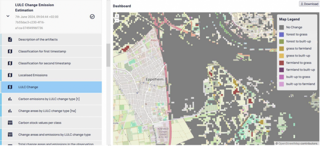
An Innovative Solution: The Online Emissions Estimation Tool
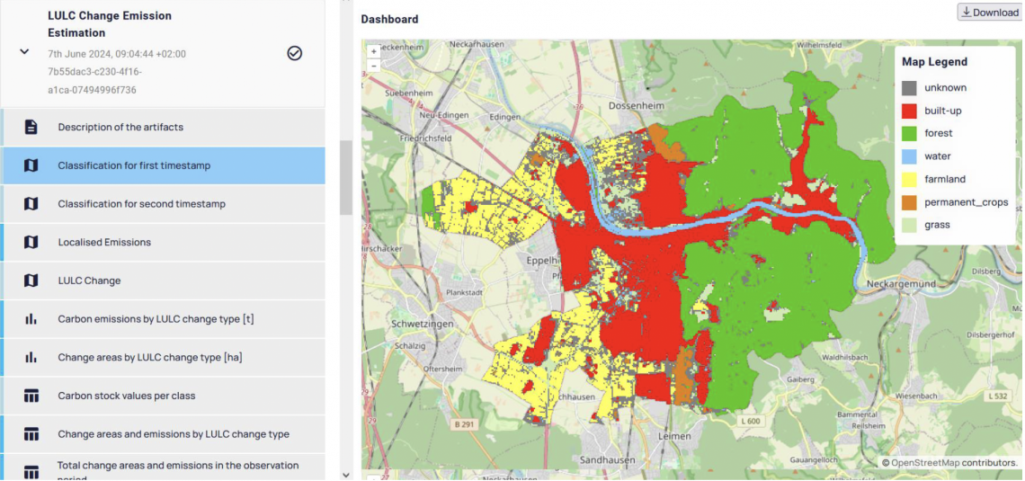
The Heidelberg Institute for Geoinformation Technology (HeiGIT) has developed an online tool that estimates CO2 emissions from land use changes. This tool offers several innovative features:
- Emissions Map: A detailed map that identifies local emission hotspots and sinks.
- High Spatial Resolution: Using Sentinel-2 satellite images with a resolution of 10 meters and digital terrain models.
- User-Defined Study Period: Users can determine the period of analysis.
- Estimation of Emissions and Sinks: Based on carbon storage in various land use classes.
Methodology and Pilot Study
The tool uses Sentinel-2 satellite images and estimated carbon storage values for different land use classes. Land use changes are identified by comparing carbon storage values before and after the change. The method was validated in a pilot study in the city of Heidelberg. The results showed that 0.2% of Heidelberg’s area underwent land use changes, resulting in net emissions of 112 tons of CO2.
Challenges and Research Needs
Despite the progress, uncertainties remain that need further research:
- Classification Accuracy: Noisy images and mixed pixels can affect the accuracy of land use classification.
- Emission Estimation: Assumptions about carbon storage values and their temporal changes can make emission estimates inaccurate.
- Unaccounted Emissions: Currently, only emissions from vegetation removal are considered, not those from construction activities.
Outlook
The tool will be expanded in the future with additional climate-relevant indicators and made available on an open-source online platform. There are plans to extend its applicability to other climate zones and land use classes to ensure global usability. By providing highly detailed spatial information, municipalities like Zukunftsleben can develop targeted measures to reduce CO2 emissions and move closer to their climate neutrality goals.
Conclusion
Quantifying CO2 emissions from land use changes is a complex but essential field in climate protection. The tool presented at the Dresden Land Use Symposium offers a promising approach to accurately capture these emissions and thus enable targeted measures for emission reduction. The work of HeiGIT’s climate action team is a significant step toward better understanding and effectively combating CO2 emissions caused by land use changes.
The climate action team at HeiGIT, represented by Kirsten von Elverfeldt, is always available for inquiries at kirsten.vonelverfeldt@heigit.org.