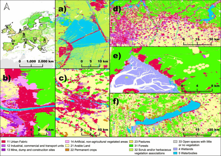
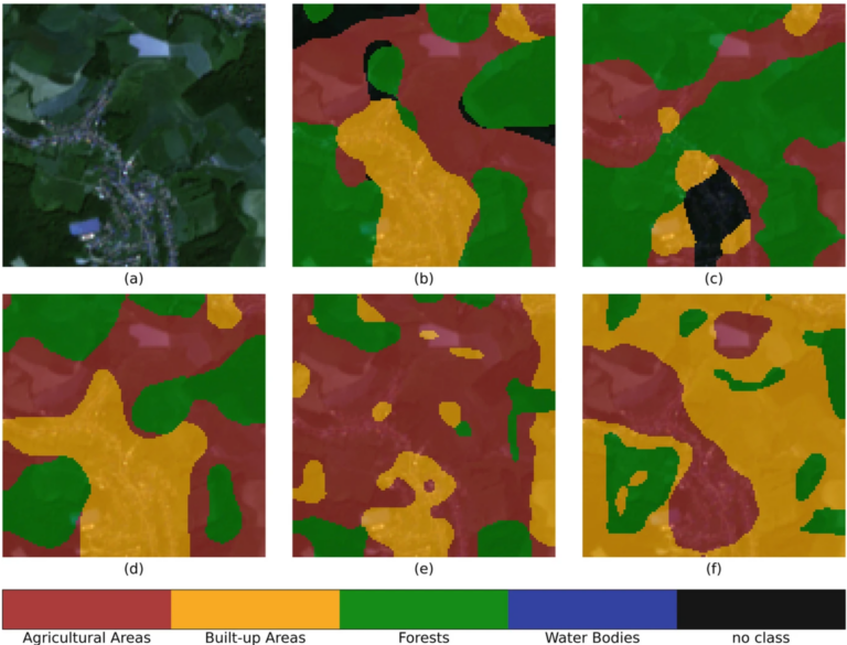
The paper, published in Nature Scientific Data, presents the first high-resolution (10m or finer) land use map of the European Union derived from a large-scale fusion of OpenStreetMap (OSM) and…
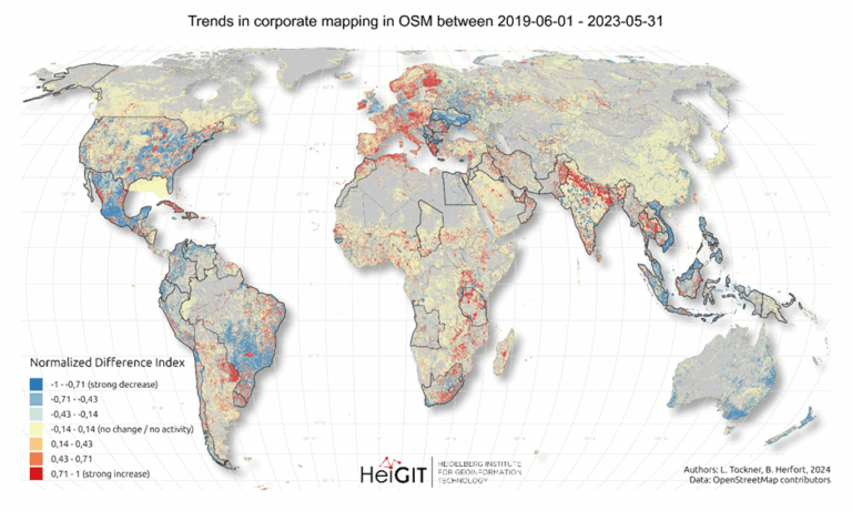
Since 2016, corporate involvement in OpenStreetMap (OSM) has grown significantly, with major contributors such as Apple, Microsoft, Meta, and Amazon making substantial edits to the map on a global scale….
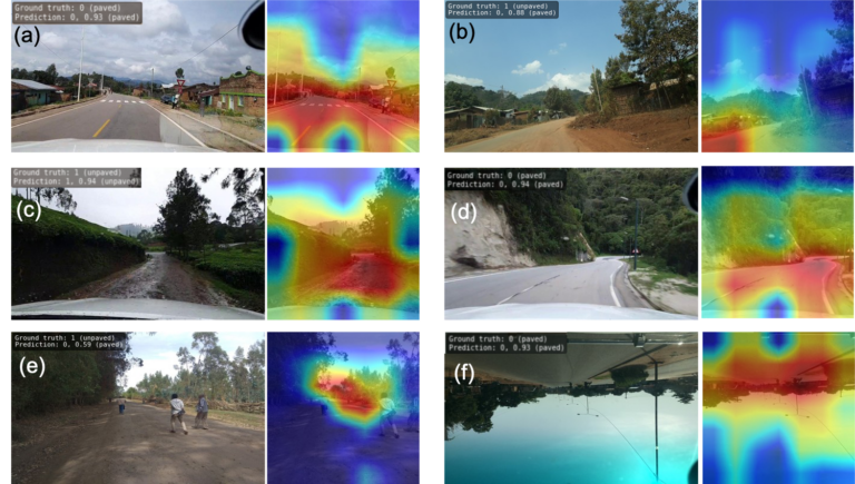
The paper addresses the global shortage of detailed road surface data by leveraging street-view imagery from Mapillary and advanced deep learning techniques. Traditional datasets like OpenStreetMap (OSM) often lack comprehensive…
We are excited to share the release of the ohsome-planet – a new software library on GitHub, marking a significant step toward the development of ohsome 2.0. This tool is…
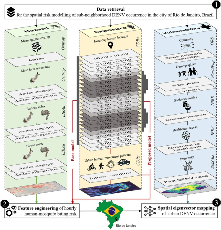
Scientific Reports publishes a paper by Steffen Knoblauch et al. that underscores the critical importance of integrating vector ecology and human behavior into advanced disease modeling frameworks. The increasing availability…
The concept of a „Digital Earth“ has long envisioned a future where technological advancements enable the large-scale collection and visualization of spatial and environmental data. Today, open data sources such…
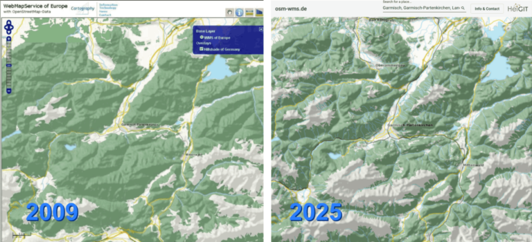
Nach 16 Jahren wird die Webseite osm-wms.de und der dahinterliegende Kartendienst im März 2025 abgeschaltet. Als das Projekt im Februar 2009 online ging, war die Besonderheit, dass wir die Daten des…
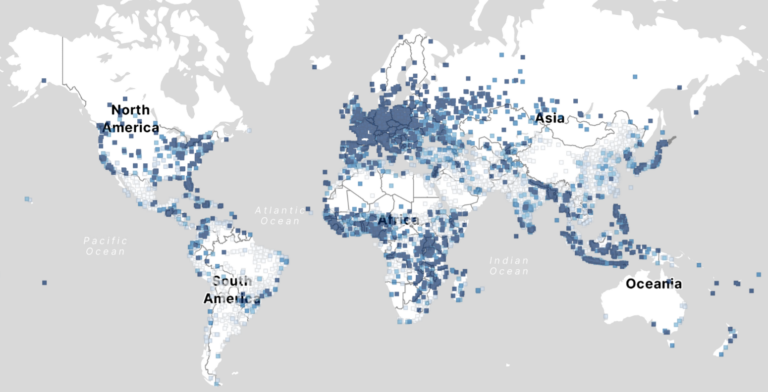
Free and open-source map data has become a keystone for research across diverse fields. The extensive coverage of OpenStreetMap (OSM) data allows scientists to conduct independent studies without relying on…
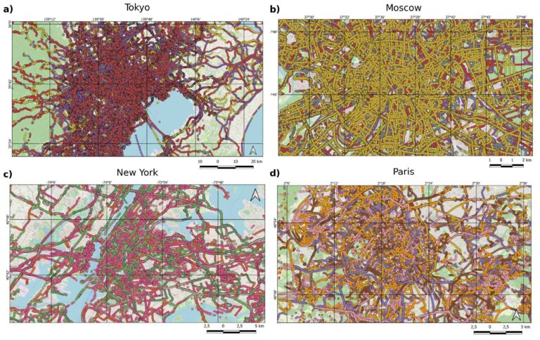
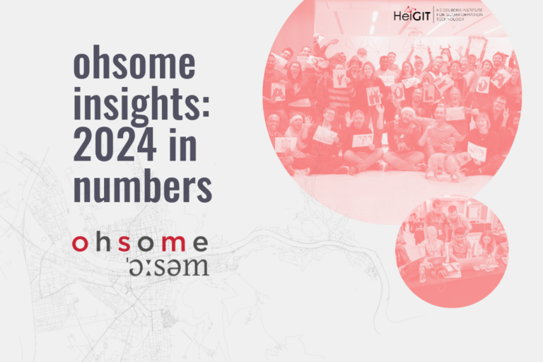
Explore some of metrics from ohsome tools and impact of OpenStreetMap (OSM) in 2024. From building data coverage in Baden-Württemberg to millions of API requests and contributions, these figures showcase…
Heidelberger Forschende liefern detaillierten Datensatz zu Straßenbelägen weltweit Heidelberger Forschende haben einen einzigartigen weltweiten Datensatz erstellt, der Informationen über die Beschaffenheit von Straßen liefert. Ob die Straßen befestigt oder unbefestigt…
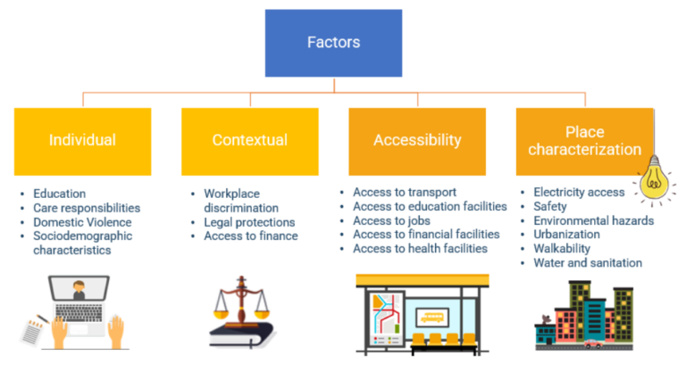
Eine Arbeitsgruppe der Weltbank betreibt derzeit Forschung, um zu beurteilen, welche räumlichen Schlüsselindikatoren die Einstellungschancen von Frauen im Bereich der erneuerbaren Energien am meisten beeinflussen. Die Forschung zielt darauf ab,…
Rapid global urbanization is placing immense pressure on planners to make informed decisions that promote sustainable growth. A crucial aspect of this challenge is understanding how urban buildings are used….
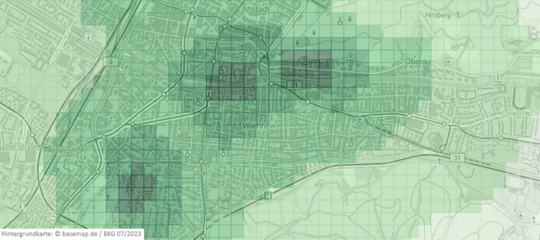
Jeden Tag kartieren tausende Menschen in OSM, wodurch die Anzahl der fehlenden Gebäudedaten in urbanen Zentren kontinuierlich zurückgeht. OSM ist eine weit verbreitete Ressource für Projekte, die die Besonderheiten urbaner…
Der 9. August ist einen Wendepunkt für die globale Kartierungsgemeinschaft: Das 20. Jubiläum von OpenStreetMap (OSM)! Seit zwei Jahrzehnten revolutioniert OSM die Art und Weise, wie wir Karten wahrnehmen und…
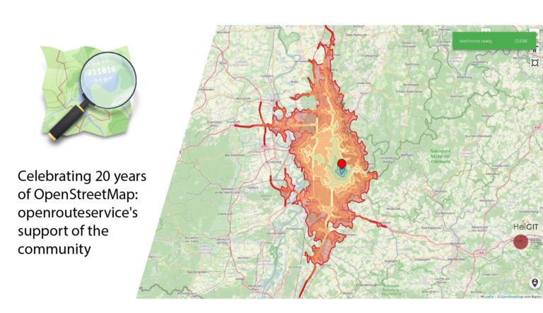
Über OpenStreetMap (OSM) und openrouteservice (ORS) werden freie Geodaten zur Verfügung gestellt, die in der Forschung und in praktischen Anwendungen vielfältig eingesetzt werden können. Die treibende Kraft hinter OSM ist…
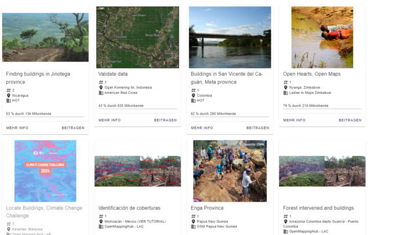
Ab jetzt kannst du mit der MapSwipe Web App von deinem Browser aus weltweit helfen und einen Unterschied machen! Seit 2015 nutzt MapSwipe die kollektive Stärke von Freiwilligen, um aktiv…
Frei zugängliche Geodaten spielen eine zunehmend wichtige Rolle. Sie kommen in der Forschung oder bei Fallstudien zum Einsatz und können wichtige Erkenntnisse über soziale, wirtschaftliche und umweltbezogene Themen liefern. Wenn…
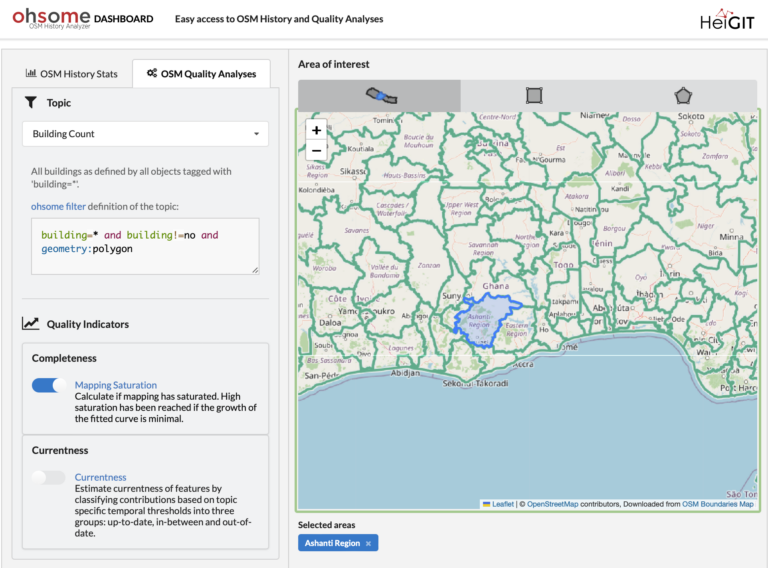
Sind Sie bereit, Ihre OpenStreetMap(OSM)-Datenanalysen auf die nächste Stufe zu bringen? Wir freuen uns, Ihnen die neuesten Funktionen des ohsome Dashboards zeigen zu können, die wir entwickelt haben, um Ihnen…
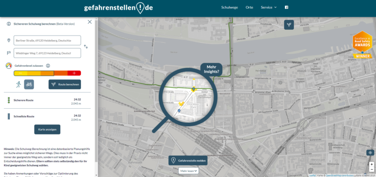
Die Nutzung von Open-Source-Geodaten erweist sich sowohl für die akademische Forschung als auch für Anwendungsfallstudien als vorteilhaft, wie Dienste wie beispielsweise openrouteservice (ORS) zeigen. Unsere Technologien haben das Potenzial, den…
Wir freuen uns, bekannt geben zu können, dass das IDEAL-VGI-Projekt von GIScience erfolgreich abgeschlossen wurde. IDEAL-VGI war ein Tandemprojekt in Zusammenarbeit mit Begüm Demir von der TU Berlin und wurde…