Wir freuen uns, bekannt geben zu können, dass das IDEAL-VGI-Projekt von GIScience erfolgreich abgeschlossen wurde. IDEAL-VGI war ein Tandemprojekt in Zusammenarbeit mit Begüm Demir von der TU Berlin und wurde…
Eine Durchsatzratenbegrenzung wurde neu eingeführt Auf dem OpenStreetMap (OSM)-API gibt es seit kurzem eine Durchsatzratenbegrenzung, die die Auswirkungen einer bestimmten Art von Kartenvandalismus begrenzen soll: neue Nutzer*Innen melden sich an…
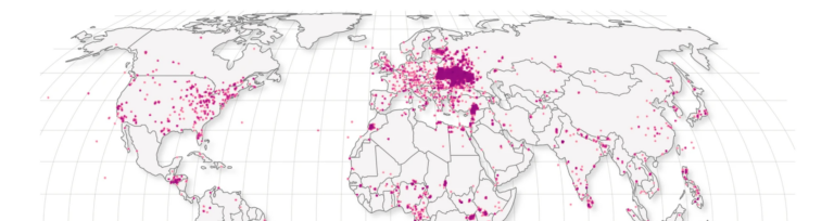
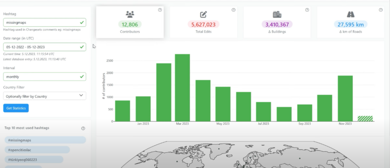
Heute möchten wir das Online-Tool OhsomeNowStats vorstellen. OhsomeNowStats ermöglicht es den Nutzern, einen Blick auf die Kartierungsaktivitäten in OpenStreetMap zu werfen. Dies ist besonders für humanitäre Organisationen und Organisatoren von…
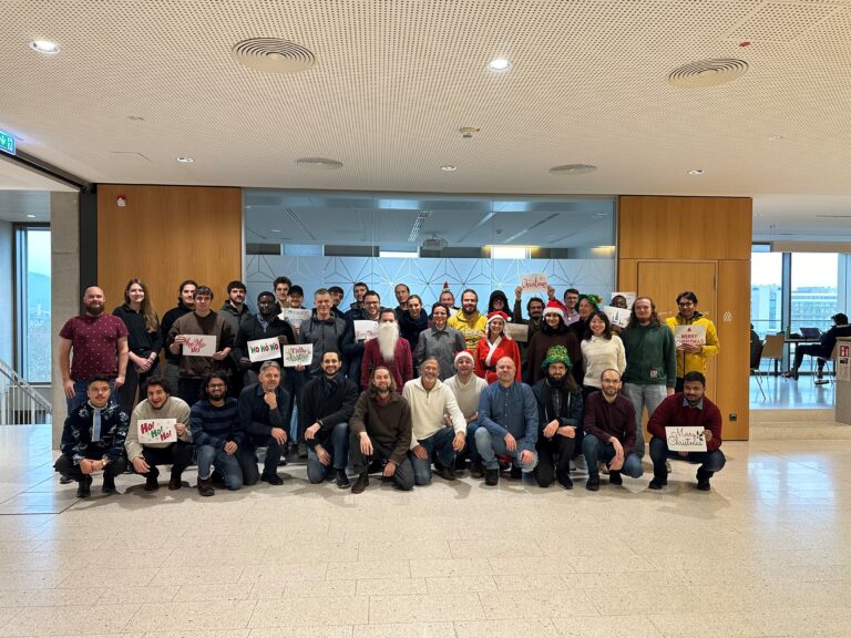
As 2023 is coming to an end, we would like to take the opportunity to look back at this eventful year and appreciate the advance that HeiGIT has made towards…
The HeiGIT team recently secured the top position in the third edition of the Open Source Software for Sustainable Development Goals (OSS4SDG) hackathon. These hackathons are based on the 17…
Introduction In this blogpost we are taking a look at humanitarian mapping through the Tasking Manager (HOT-TM) that is operated by the Humanitarian OpenStreetMap Team (HOT). At HeiGIT we work…
We would like to congratulate Dr. Christina Ludwig on successfully defending her PhD on how to map urban green spaces using OpenStreetMap (OSM) data last month. In her thesis Christina…
The completeness of the OpenStreetMap (OSM) road network has been an ongoing focus for researchers for more than 15 years. For instance, Neis et al. (2011) investigated the OSM street…
Das Sketch Map Tool (SMT) geht dank Unterstützung durch das Deutsche Rote Kreuz (DRK) und das Auswärtige Amt in die nächste Projektphase. Unsere Hauptziele in dieser Phase sind es, neben…
Beim Katastrophenmanagement ist Zeit das A und O. Schnell und präzise zu reagieren kann den Unterschied ausmachen, wenn es darum geht, Leben zu retten und Schäden zu begrenzen. Der nächste…
Ein großes Ziel für das HeiGIT und insbesondere für das ohsome-Team ist es, wertvolle Einblicke in OpenStreetMap (OSM)-Daten zu geben. Die ohsome API bietet aggregierte Statistiken über die Entwicklung von…
Campusreporter Nils Birschmann hat mit Prof. Alexander Zipf über unser Disaster Portal gesprochen. Das Interview wurde über Radio Regenbogen ausgestrahlt. Hier könnt ihr euch den Beitrag in voller Länge anhören:…
In seiner Bachelorarbeit, betreut von apl. Prof. Dr. Sven Lautenbach am HeiGIT, untersuchte Lars Reckhaus die Eignung von OpenStreetMap (OSM) für Standortanalysen im Kontext von Wohnimmobilienprojekten. Typischerweise erfordern solche Analysen…
Mit ohsomeNow stats könnt ihr jetzt OpenStreetMap (OSM) Beiträge in Echtzeit verfolgen! Wir haben dieses neue Dashboard im Rahmen unserer langjährigen Zusammenarbeit mit dem Humanitarian OpenStreetMap Team (HOT) entwickelt, einer…
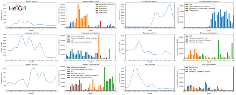
Exploring OSM editor statistics by combining data from OSHDB and changeset DB OpenStreetMap (OSM) marks one of the most successful and powerful open source, crowdsourced geomaps, with over 10 million…
Today we’d like to tell you about the Summer School Disaster Risk Reduction 2023 event hosted by the Environmental Campus of UAS Trier in Germany and organized by the German…
Benjamin Herfort und seine Kollegen Sven Lautenbach, João Porto de Albuquerque, Jennings Anderson und Alexander Zipf haben einen Artikel in dem renommierten Journal Nature Communications (Impact Factor 2023: 17.7) veröffentlicht….
Das ohsome Dashboard war und ist auch weiterhin ein einfacher Weg, genaue Statistiken über die historische Entwicklung von OpenStreetMap-Daten für beliebige Regionen zu erstellen. Nun wurde das ohsome Dashboard um…
After introducing the OSM Element Vectorisation Tool last week, we now want to show possible use cases and specific examples of what the tool can do. This third and last…
Nach dem wir letzte Woche das OSM Element Vectorisation Tool vorgestellt haben, wollen wir nun mögliche Anwendungsfälle und spezifische Beispiele für die Nutzung und Anwendung des Tools präsentieren. Dieser zweite…