Das IDEAL-VGI Forschungsprojekt nähert sich seinem Ende. Und obwohl dies nicht das Ende unserer Forschung zu sozialen Datenquellen, Datenqualitätsanalysen und Landnutzungsinformationen sein wird, freuen wir uns, ein wichtiges Ergebnis ankündigen…
Sketch Map Tool (SMT) – An easy-to-use way to create and digitalize paper maps for offline data collection in the field The HeiGIT (Heidelberg Institute for Geoinformation Technology) team recently…
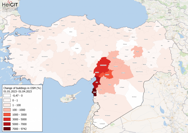
Gezeigte Karte: Prozentuale Veränderung von Gebäuden in jeder Provinz der Türkei und Syriens in OSM. Daten von OpenStreetMap, visualisiert mit QGIS und dem ohsome API Plugin. Willkommen zurück zu unserer…
Gezeigtes Bild: Abbildung 1. Gesamtkohlenstoffflüsse bezogen auf LULCC in Baden-Württemberg zwischen März 2018 und Oktober 2019 (LaVerDi, OSMlanduse+) und März 2018 und März 2020 (OSMlanduse, OSMlanduse bereinigt). Der obere Plot…
Da der Verkehrssektor einer der größten Verursacher von Treibhausgasemissionen ist, der in den letzten Jahrzehnten keine nennenswerten Emissionssenkungen verzeichnen konnte, muss er von den politischen Entscheidungsträgern besonders berücksichtigt werden. Schätzungen…
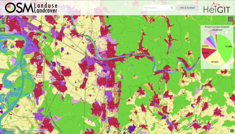
Wir freuen uns ankündigen zu können, dass https://osmlanduse.org ein Funktionalitätsupdate erhalten hat. Dank der Kooperation von GIScience und HeiGIT im IDEAL-VGI Projekt, konnten unsere Forscher die interaktive Karte um eine…
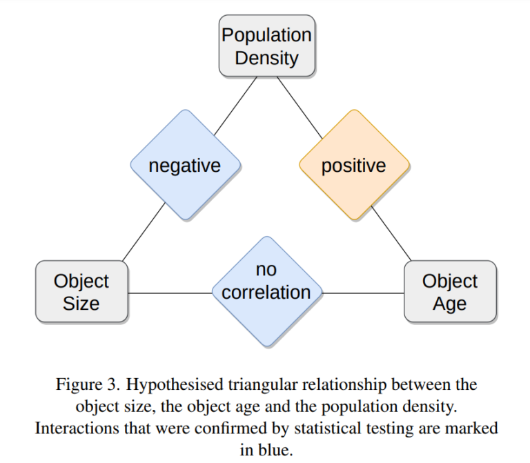
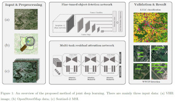
Gezeigtes Bild: Abbildung 3 aus dem Paper. Einer der Beiträge, die das HeiGIT/GeoScience-Team auf der letztjährigen Konferenz Free and Open Source Software for Geospatial (FOSS4G) 2022 vorstellte, war das neue…
Beitragsbild: Ohsome-Dashboard-Interface für Heidelberg, Deutschland. Mit den Worten von Konfuzius: „Der Mann, der einen Berg versetzt, beginnt damit, kleine Steine wegzutragen.“ Mit der Veröffentlichung der OSHDB (OpenStreetMap History Database) Version…
Am 02.11.2022 haben wir 10,107,826,483* Objekte in unserem oshdb erreicht. Das ist definitiv ein Grund zum Feiern! *Für Informationen über die Hintergrundfigur lesen Sie unser Basic guide to OSM data…
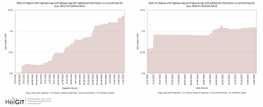
Willkommen zurück zu unserer ohsome Region des Monats-Serie! In diesem Post werden wir uns die zeitliche Entwicklung von Highways und hinzugefügten smoothness-information, sowie soziale Einrichtungen und neue Kartierungsentwicklungen in Kyiv…
Wir haben aufregende Neuigkeiten! Wie viele von Ihnen wissen, erfolgten die OSHDB-Updates in der Vergangenheit wöchentlich und führten zu einer Verzögerung zwischen den Daten in OpenStreetMap (OSM) und unserer Datenbank….
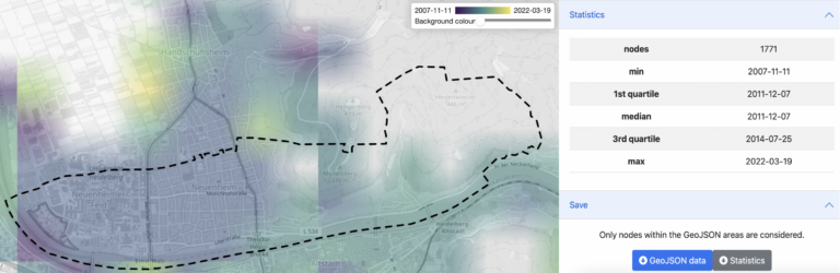
Einführung Seit der Veröffentlichung des ohsome quality analyst (kurz OQT) im Februar letzten Jahres haben wir an der Entwicklung eines zugänglichen und dennoch leistungsfähigen Toolkits gearbeitet, das Endnutzern Einblicke in…
Hallo und herzlich willkommen zu unserer Serie „Wie man ohsome wird“, in der wir zeigen, wie auch Sie ohsome werden können mit ohsome API! Wenn Sie noch nicht mit der…
Endlich zurück! Willkommen zu einem weiteren Teil unserer Wie man ohsome wird-Serie! Dieser Beitrag ist besonders, da wir die Anwendung eines Drittanbieters diskutieren, die von der ohsome API als Back-End…
Willkommen zurück zu einem neuen Teil der Blogserie ohsome Region des Monats! Dies wird Teil zwei unserer Posts zu Tags im Zusammenhang mit Wanderungen sein, und dieses Mal werden wir…
Seit der Veröffentlichung des ohsome Quality Analyst (Short OQT) im Februar letzten Jahres haben wir an der Entwicklung eines leicht zugänglichen, aber leistungsstarken Toolkits gearbeitet, das Endbenutzern Einblicke in die…
Humans rely on clean water for their health, well-being, and various socio-economic activities. During the past few years, the COVID-19 pandemic has been a constant reminder of about the importance…
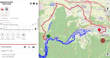
Unterführungen, Treppen und hohe Bordsteinkanten sind für Menschen mit Gehbeeinträchtigungen eine große Herausforderung. Ein maßgeschneiderter Routenplaner kann aber ihre Mobilität erhöhen, indem er Wege mit möglichst wenigen Hindernissen berechnet. Dieses…
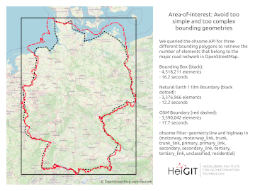
Working with OpenStreetMap data is an exciting topic that often reveals astonishing insights. The free and open nature of the project allows a plethora of analyses topics. We at HeiGIT…
Hello and welcome back to the How to become ohsome-blog series! We hope the new year started off well for you! If you’re new to the series, you should read…

![Figure 1. Total carbon fluxes related to LULCC in Baden-Württemberg between March 2018 and October 2019 (LaVerDi, OSMlanduse+), and March 2018 and March 2020 (OSMlanduse, OSMlanduse cleaned). The upper plot shows the relative difference of carbon fluxes [%] with respect to LULC transition and carbon flux attribution method. The carbon fluxes of method 1 are set to 0. The lower plot shows the total absolute carbon fluxes [Mg C] calculated with carbon flux attribution method 1 with respect to LULC transition and LULCC method.](https://heigit.org/wp-content/uploads/2023/05/ed501d68-7952-4263-a23e-a5f8a81fa7a4-768x873.png)