Innovative Water Management Solutions through AI and Geoinformatics
Overview
Access to clean water is essential for disaster response, climate change mitigation, and sustainable development. Wastewater Treatment Plants (WWTPs) are crucial for purifying water and developing effective climate mitigation strategies, yet accurate data on these facilities is often missing, particularly in developing regions where reliable access to clean water is also lacking. In the context of natural disasters, the swift identification and allocation of resources like water are also vital, as delays can severely hinder relief efforts.Some WWTPs are also a source of greenhose gases. Remote sensing can support the monitoring of emissions from these facilities to ensure they comply with environmental regulations.
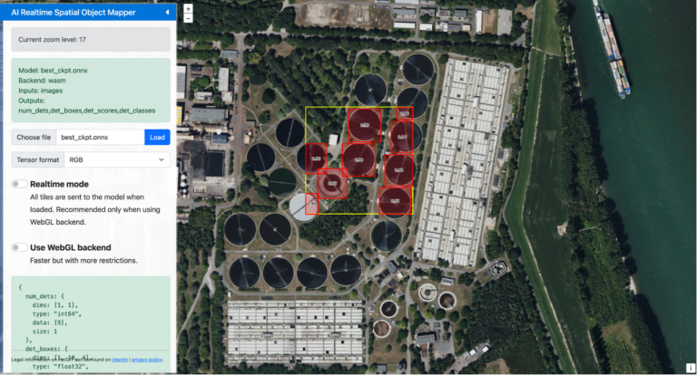
HeiGIT and the GIScience teams have developed GeoAI4Water, a cutting-edge solution that uses Machine Learning and Deep Learning models to map these vital infrastructures from satellite imagery. This tool empowers governments and responders with the data needed to mitigate the impacts of disasters, enhance water resource management, and meet environmental standards.
Challanges
WWTP Identification Variability
Wastewater Treatment Plants vary widely in appearance, size, and texture, making them difficult to detect through earth observation data.
Data Gaps in Developing Regions
Reliable information on WWTPs is scarce, especially in regions lacking clean water access.
Environmental Compliance
Some wastewater plants emit greenhouse gases, requiring remote monitoring to ensure compliance with regulations.
GeoAI4Water Solutions
Harnessing AI and Satellite Data for Enhanced Wastewater Treatment Detection
GeoAI4Water addresses challenges by employing deep learning algorithms that analyze high-resolution satellite imagery to detect WWTPs. By focusing on regions with limited alternative data sources, the project supports both climate action and disaster preparedness.
Key Features
AI-Based Detection of Wastewater Treatment Plants
GeoAI4Water utilizes deep learning algorithms to accurately detect WWTPs, minimizing false positives and ensuring precision. This helps decision-makers gain clearer insights into critical water infrastructures.
Earth Observation for Data Scarcity Regions
By leveraging earth observation data from satellites, GeoAI4Water fills the gaps where on-the-ground data is unavailable. This ensures water management can proceed even in data-scarce areas.
Remote Monitoring for Climate Mitigation
GeoAI4Water supports the remote monitoring of emissions from WWTPs, ensuring compliance with environmental regulations and contributing to overall climate mitigation strategies.
Applications
The GeoAI4Water project supports broader applications for climate resilience, urban planning, and infrastructure management.
Applications include:
Wastewater Treatment Capacity Estimation
AI helps estimate the capacity and efficiency of treatment plants to optimize water purification.
Urban Planning
Data generated by GeoAI4Water can enrich OpenStreetMap (OSM) and influence land use planning in developing regions.
Disaster Response
Identifies critical water infrastructure quickly during disasters to ensure resource allocation without delay.
Funding
GeoAi4WATER I, II and Thailand phases are funded by KSB Group. The project builds on the collaboration between HeiGIT and the GIScience Research Group.
Ongoing Projects
April - Aug. 2025
GeoAI4Water III Spatial Characterisation
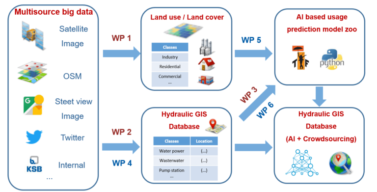
GeoAI4Water III advances the spatial characterization of WWTPs through cutting-edge technologies in AI and geospatial analysis. This phase refines size attribution using DL segmentation, while multimodal AI models integrate urban and industrial classification to determine plant purpose. Additionally, capacity estimation uses geospatial analysis to link detected WWTPs with population density, land use, and water demand, providing a more detailed and multidimensional view of wastewater infrastructure beyond mere detection.
By integrating advanced AI frameworks, remote sensing data, and scalable computational techniques, GeoAI4Water III aims to enhance global wastewater mapping, supporting data-driven decision-making for water management and sustainability. This project is in collaboration with Climate Trace where we aim to release an open- global dataset on WWTPs with AI derived spatial characteristics.
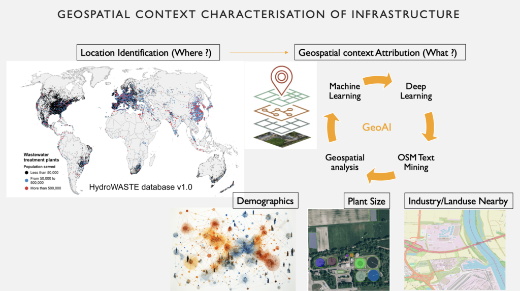
Geospatial context characterisation of infrastructure
Completed Projects
GeoAI4Water I
2022
The initial GeoAI4Water project conducted a proof-of-concept study on predicting and mapping diverse water-related infrastructure using heterogeneous geospatial big data, including OpenStreetMap, Sentinel-2 MSI data, and VHR satellite imagery.
This project established the first prototype solution, demonstrating its feasibility in supporting market management and business decision-making.
The project achieved significant scientific findings and development progress, laying the groundwork for future advancements in GeoAI-based models with spatial knowledge integration. Nevertheless, the models trained to detect wastewater treatment plants produced several false positives, which required reduction through post-processing.
The proposed solution prototype for predicting and mapping of water-Related infrastructure from heterogeneous geospatial big data
GeoAI4Water II
January - December 2023
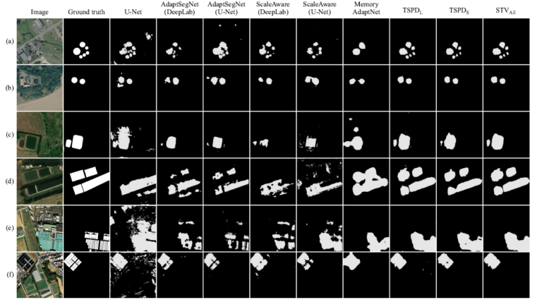
GeoAI4Water II develops scalable methods for global water infrastructure mapping. The project tackled false positive reduction by exploring alternative architectures, methodologies, and data strategies. A major challenge was detecting wastewater treatment plants (WWTPs) in developing countries with limited data and varying infrastructure conditions. To address this, a novel multiscale, multifeature hybrid model leveraged advanced deep learning frameworks (Yolov6, RTMDET, EfficientDET, and Domain Adaptation) to enhance accuracy and expand geographic coverage.
Validated across Germany, France, Malaysia, the USA, and Africa, this approach uncovered previously unmapped WWTPs in databases like OpenStreetMap. Despite its potential for urban planning, climate action, and critical infrastructure mapping, global dataset generation remains limited by high-resolution satellite imagery availability.
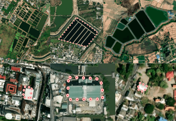
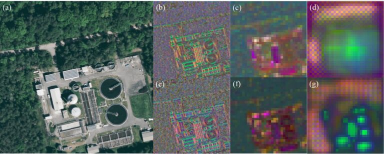
Feature Maps forWastewater treatment Plants (WTPs). (b)-(d) for training on wholeWTPs and (e)-(g) on individual WTP features
GeoAI4Water II: Thailand case study
February - November 2025
The GeoAI4Water project in Thailand focuses on detecting WWTPs using deep learning models applied to high-resolution satellite imagery. It aims to support disaster planning and resource allocation in a region prone to natural disasters. Additionally, from a climate perspective, the tool has the potential to estimate methane emissions from WWTPs more accurately, contributing to better climate action and mitigation strategies.
Feature Maps forWastewater treatment Plants (WTPs). (b)-(d) for training on wholeWTPs and (e)-(g) on individual WTP features