Sketch Map Tool

Empowering Communities Through Participatory Mapping

A Low-Tech Solution for High-Impact Mapping

Overview

The Sketch Map Tool is an easy-to-use tool for participatory mapping through offline collection, digitization, and georeferencing of local data. The low-tech solution simplifies the gathering and analysis of spatial knowledge and perceptions using pens and paper maps, the so-called Sketch Maps. As an open-source web application, the tool supports the creation, use, and subsequent digitization and analysis of paper-based maps, integrating OpenStreetMap and satellite data (ESRI world imagery).

berlin hex deco image

Basic Functionalities of the Sketch Map Tool

Create paper maps
Participatory mapping
Paper to GIS

Collecting the Data

Define your area of interest and your base map, look at the OSM Map Quality check and export the map as PDF.

Mapping in the Field

Data collection with local communities in- and outdoor with pens on paper Sketch Maps.

Digitalise your Sketch Maps

Scan or photograph your marked Sketch Maps, upload the images to Sketch Map Tool and download collected markings as geodata. You will need a GIS to open it, we recommend QGIS or umap.

Participatory Mapping: Facilitates community involvement with a focus on marginalized groups by providing a mapping option with basic tools like paper and pens.

Customized maps: Supports various paper sizes and offers two base map options—OpenStreetMap and satellite imagery—to accommodate diverse mapping projects.

Offline Functionality: Designed for use in low-tech environments, allowing analogue mapping without digital devices.

Automatic Digitization: Uses AI and computer vision to digitize and georeference markings on paper maps.

Multi-Language Support: Available in English, German, French, and Spanish, broadening its accessibility.

Training and Exercises: Offers a help page and FAQ section with step-by-step introductions and recommendations to support users in their mapping activities.

Applications

Disaster Preparedness:

Mapping local knowledge about disasters, including past experiences, risk perceptions, and vulnerabilities.

Urban Planning:

Use the tool to visualize and deliberate on community aspirations, enhancing long-term planning efforts.

Environmental Monitoring:

Helps map areas of environmental degradation and inadequate infrastructure to better understand and address local risks.

Development and Support

The Sketch Map Tool is based on research into flood risk perception and participatory mapping with Field Papers(Field Papers) (Klonner, Usón, et al., 2021). These studies highlight the need to combine both analogue and digital mapping techniques to bridge the gaps between stakeholders and streamline data collection and analysis. The Sketch Map Tool prototype was developed as a part of the Waterproofing Data project (Klonner, Hartmann, et al., 2021; Porto De Albuquerque, 2023; Klonner et al., in preparation), funded by the Federal Ministry of Education and Research.

Developed in close collaboration between HeiGIT and the GIScience Research Group at Heidelberg University, the prototype was upgraded with an improved interface and computer vision-based colour detection. Since then, it has been applied and tested within humanitarian and research case studies in urban and rural areas in the Global North and South.

  • Using sketch maps to capture flood risk perception for urban flooding in Santiago de Chile (Chile)

    Klonner et al. (2018) & NEOHAZ project. These case studies were based on Field Papers.

    Sponsors

    WIN-Kolleg
  • Using sketch maps to capture flood risk perception for river flooding in Eberbach (Germany)

    Klonner et al. (2021) & NEOHAZ project. These case studies were based on Field Papers.

    University Project

    Development of the first Prototype in the WPD-Project (Waterproofing Data)

    First analysis of OSM-Data

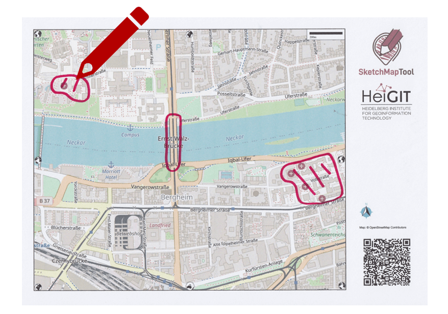
    Generation of different paper formats & geo-referencing

    Sponsors

  • Major improvement of the Prototype in cooperation with the RC Madagascar

    Experiments and the first implementation of colour-detection

    Sponsors

  • Evaluation of user benefits and needs in EVCA context (Columbia and EVCA-community)

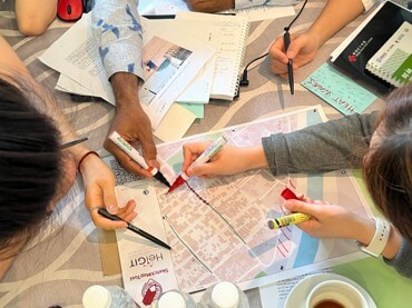
    Usability evaluation of the Sketch Map Tool in the EVCA context in a case study in Columbia with expert interviews and surveys

    Sponsors

  • Relaunch stable version

    First public online version of the Sketch Map Tool, with an improved user interface

    Sponsors

  • Newest relaunch of the stable version

    Improved marking detection

    Integration of satellite images

    Improved training and help page

    Available now also in German, French and Spanish

    Sponsors

Supported by the German Red Cross and funded by the German Federal Foreign Office through the Globalprojekt II, the tool has been enhanced and expanded for broader use within the Red Cross Red Crescent Movement and similar organizations. The 2023 relaunch integrated satellite imagery as a base map, improved color detection, and ensured greater software stability. Customized training materials were also developed to accommodate users with varying levels of expertise.

The Sketch Map Tool is now part of the HeiGIT tools, contributing to the reduction of disaster impacts through innovative humanitarian approaches.

Sponsors

Resources

Timor-Leste

Utilized for cultural research and community mapping to address local challenges.

Cultural Research

Demonstrates the tool’s adaptability in various contexts, showcasing its role in integrating local knowledge into planning.

Klonner, Carolin, Maximilian Hartmann, Lily Djami, and Alexander Zipf. 2019. “‘Ohsome’ OpenStreetMap Data Evaluation: Fitness of Field Papers for Participatory Mapping.” https://wiki.openstreetmap.org/w/images/8/89/%E2%80%9COhsome%E2%80%9D_OpenStreetMap_Data_Evaluation-_Fitness_of_Field_Papers_for_Participatory_Mapping.pdf.
Klonner, Carolin, Maximilian Hartmann, Rebecca Dischl, Lily Djami, Liana Anderson, Martin Raifer, Fernanda Lima-Silva, Lívia Castro Degrossi, Alexander Zipf, and João Porto de Albuquerque. 2021. “The Sketch Map Tool Facilitates the Assessment of OpenStreetMap Data for Participatory Mapping.” ISPRS International Journal of Geo-Information 10 (3): 130. https://doi.org/10.3390/ijgi10030130.

See all posts

Contact