Transforming Landscape Monitoring with OpenStreetMap and Satellite Data
Integrating Geospatial Insights for Continuous Landscape Change Detection in Germany
Overview
The project seeks to provide continuous updates on landscape changes by integrating satellite data with OpenStreetMap (OSM) information. LaVerDi (Landschaftveränderungsdienst) is a service offering free access to geodata on landscape changes in Germany, available to institutions and the public. Since late 2020, the Federal Agency for Cartography and Geodesy (BKG) has been hosting LaVerDi as an operational online mapping service. This service leverages free Copernicus satellite data to deliver annual, automatically derived insights for regular monitoring of landscape changes in Germany.
Given the growing volume and accuracy of OSM data, especially in frequently updated urban areas, combining user-contributed information with satellite-derived data presents an opportunity to detect landscape changes more effectively. This approach enables higher update frequencies, potentially even continuous monitoring. Additionally, the project will explore how OSM-supported methodologies can aid in identifying data updates for systems like ATKIS and LBM-DE.
Research Questions
1. Effectiveness of OSM Crowdsourcing
Can OSM-based crowdsourcing methods improve the results of LaVerDi operated by BKG?
2. Nationwide Land Cover Dataset
Is it feasible to create a nationwide, crowdsourcing-supported, quality-assured land cover dataset that is more up-to-date than the current LaVerDi service?
Project Goals
Develop, evaluate and prototype
Explore how landscape changes or key object classes relevant to BKG (e.g., LBM-DE or CLC) can be derived and quality-checked using OSM data.
Investigate insights from satellite data
Assess how change detection insights derived from satellite data can be utilized to update OSM datasets.
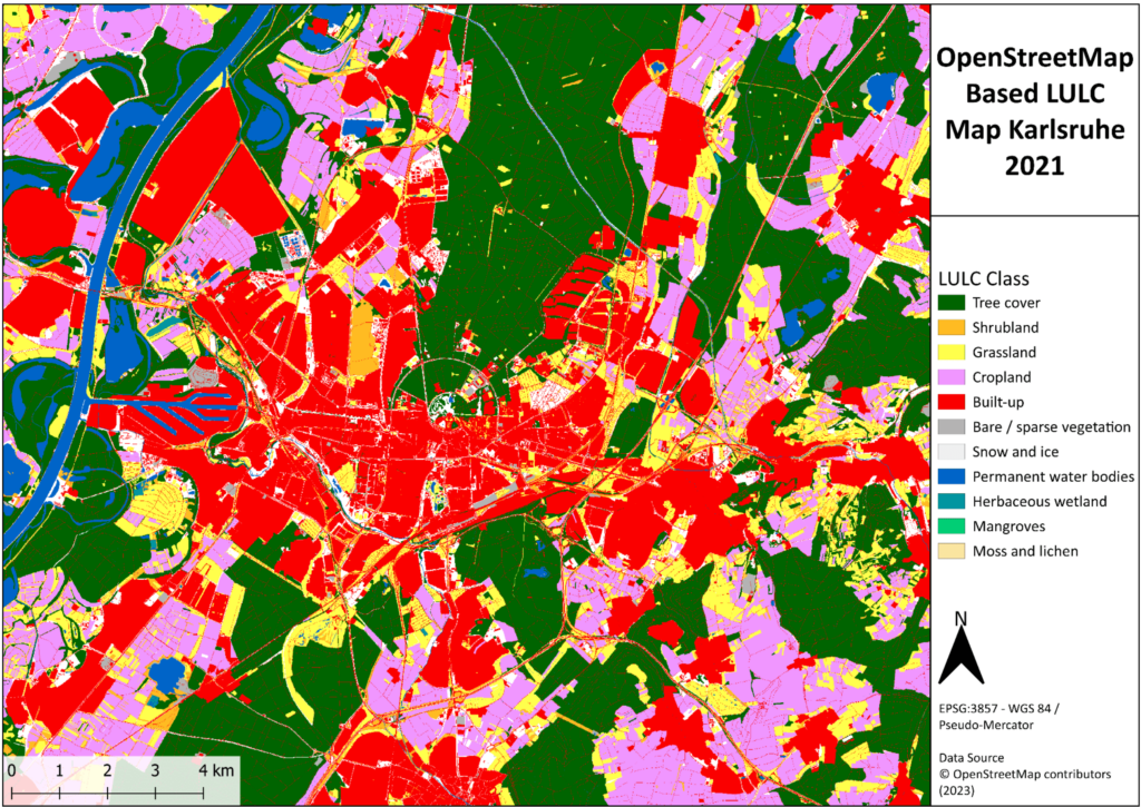
OpenStreetMap based LULC Map generated for Karlsruhe
Key phases
Design
Implementation
Validation
Deployment
Design and Concept Development
Defining methodologies for integrating satellite and OSM data.
Implementation and Testing
Developing machine learning techniques for real-world change detection in OSM.
Crowdsourcing and Gamification
Crowdsourcing validation of detected changes through MapSwipe / MapSwipe4Web. Analysis of gamification strategies to enhance user engagement, and develop a user-friendly web interface.
Deployment
Deploying a mobile validation app with gamification elements and integrating LaVerDi data into OSM.