Knoblauch, S; Su Yin, M.; Chatrinan, Krittin; Rocha, Antonio A. de A.; Haddawy, P.; Biljecki, F.; Lautenbach, S.; Resch, B.; Arifi, D.; Jänisch, T.; Morales, I.; and Zipf, A published the paper ‘High-resolution mapping of urban Aedes aegypti immature abundance through breeding site detection based on satellite and street view imagery’ in Nature Scientific Reports.
The mosquito species Aedes aegypti is a major vector responsible for transmitting several serious communicable diseases, including dengue, yellow fever, chikungunya, and Zika. Its growing threat is exacerbated by environmental changes associated with climate change, urbanization, and increased resistance to insecticides. Dengue fever alone caused 390 million infections globally in 2020, reflecting a 30-fold increase over the last fifty years. This alarming trend has spurred numerous efforts to improve surveillance methods for Aedes aegypti, aiming to predict disease outbreaks and enhance vector control measures.
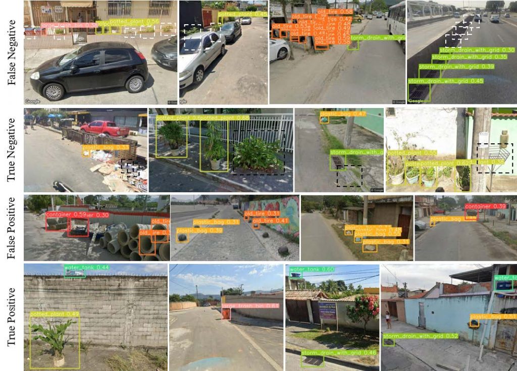
The biology of Aedes aegypti presents significant challenges to developing effective monitoring techniques. This mosquito prefers urban environments, breeding in small, often ephemeral, artificial water containers. Its limited flight range of less than 1,000 meters without wind assistance results in high spatial variability of mosquito populations, making traditional sampling methods costly and labor-intensive. To address these challenges, using the increasing availability of open-access spatial data and modern computing technologies offers a promising solution. By applying state-of-the-art computer vision models to satellite and street view imagery, HeiGIT & GIScience researchers can detect common breeding sites and generate high-resolution urban micro-habitat indicators. This innovative approach allows for more accurate mapping of mosquito abundance at a city-wide scale, optimizing vector control efforts and potentially reducing the incidence of mosquito-borne diseases.
Reference:
Knoblauch, S; Su Yin, M.; Chatrinan, Krittin; Rocha, Antonio A. de A.; Haddawy, P.; Biljecki, F.; Lautenbach, S.; Resch, B.; Arifi, D.; Jänisch, T.; Morales, I.; Zipf, A. (2024): High-resolution mapping of urban Aedes aegypti immature abundance through breeding site detection based on satellite and street view imagery. https://www.nature.com/articles/s41598-024-67914-w
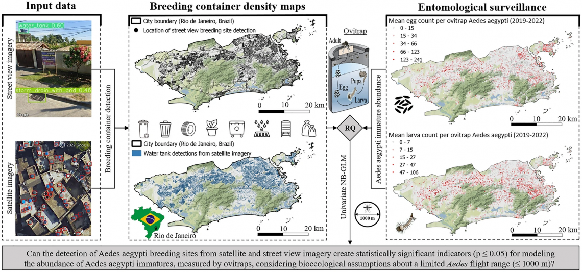
*Title image description: Workflow of evaluating the density of Aedes aegypti breeding container detections for modeling immature mosquito abundance at flight range scale in the city of Rio de Janeiro, Brazil. The mapping of Aedes aegypti breeding containers was carried out using satellite and street view imagery by applying and fine-tuning single-stage object detection networks (left). Container densities were calculated within a circular flight range buffer of 1000 m around ovitrap locations. For the evaluation of the research question, univariate negative binomial regression models were trained using temporally aggregated egg and larva counts from entomological surveillance (middle). Entomological surveillance data about immature abundance of Aedes aegypti was collected by the municipal health ministry of Rio de Janeiro (right). ©2023 Google.