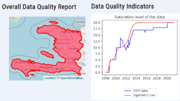
The ohsome quality analyst (short: OQT) has been introduced at the beginning of this year and today we are proud to announce two updates. First, we released the new version…
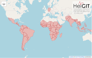
After Sub-Saharan Africa and South and Southeast Asia we have now published all countries of Central and South America on the Open Healthcare Access Map. The web application is available…
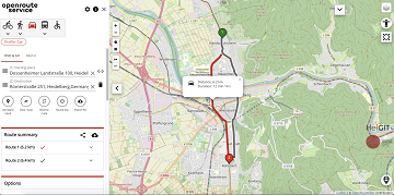
Seit kurzem nutzt die Stadt Mannheim openrouteservice (ORS) von HeiGIT für das Routing von Fußgängern, Fahrräder, Autos, LKW und Rollstuhlfahrern im Online-Stadtplan für die breite Öffentlichkeit, d.h. die Bürger und…
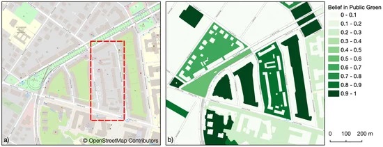
Public urban green spaces are important for the urban quality of life. Still, comprehensive open data sets on urban green spaces are not available for most cities. As open and…
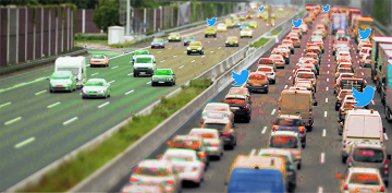
Up-to-date traffic information is a prerequisite for navigation solutions to determine the best route and travel time. In the SocialMedia2Traffic project by HeiGIT and GIScience Heidelberg , conclusions about current…
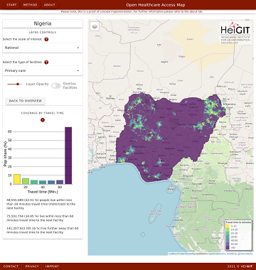
Open Healthcare Access Map is a new web application by HeiGIT to provide insights into healthcare supply on different spatial scales for many countries worldwide. The web application is available…
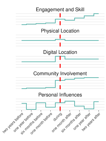
Online knowledge projects such as OpenStreetMap (OSM) and Wikipedia have gained high importance, trust and even economic value. These projects and their content are maintained and enhanced by online communities…
Sie lieben Open-Source-Geoinformationsdienste zu entwickeln, die täglich von Tausenden genutzt werden? Sie sind ein hochmotivierter Java Backend-Entwickler und Algorithmen-Designer? Und Sie wollen OpenStreetMap für leistungsstarke GI-Dienste mit globaler Abdeckung einsetzen…
Aktuelle Verkehrsinformationen sind die Voraussetzung für Navigations-Lösungen, um die beste Route und Fahrzeit zu bestimmen. Es gibt jedoch keine frei verfügbaren Verkehrsinformationen auf weltweiter- und Bundesebene. „SocialMedia2Traffic nutzt frei verfügbare…
We are happy to announce that the new openrouteservice maps client has been finished and released. It is an open source route planner with plenty of features for car, heavy…
Extreme natural events create catastrophic situations for cities and their populations. Due to climate change and anthropogenic activities, the number and intensity of these events has steadily increased at the…
HeiGIT wants to serve you better. Therefore we are conducting user feedback surveys regarding our various services. The Deadline has been extended to March 05rd! Take your chance! If you…
HeiGIT wants to serve you even better. Therefore we are conducting user feedback surveys regarding our various services. If you have ever used one of our OpenStreetMap based Online Services…
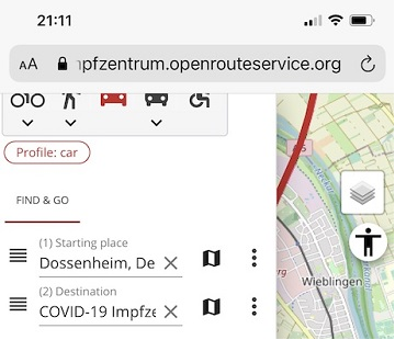
Die Universität Heidelberg berichtet aktuell über impfzentrum.openrouteservice.org NEUER ROUTENPLANER ERMITTELT DEUTSCHLANDWEIT DIE SCHNELLSTE ROUTE ZUM NÄCHSTEN IMPFZENTRUM Wo kann ich mich gegen das Coronavirus impfen lassen und wie komme ich…
Die Universität Heidelberg berichtet aktuell über impfzentrum.openrouteservice.org NEUER ROUTENPLANER ERMITTELT DEUTSCHLANDWEIT DIE SCHNELLSTE ROUTE ZUM NÄCHSTEN IMPFZENTRUM Wo kann ich mich gegen das Coronavirus impfen lassen und wie komme ich dorthin? Diese Frage…
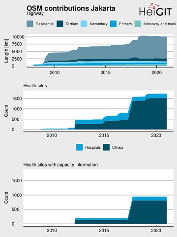
OpenStreetMap (OSM) offers many possibilities and holds potential in the area of freely available infrastructure data for the health sector. Nevertheless, it is important to underline that the quality of…
Where is is the closed Covid-19 vaccination center and what is the best way to get there? A new route planning app helps you answer this questions by suggesting ways…
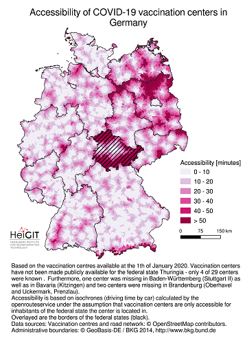
Current lockdown regulations in Germany state that – in many but not all federal states – travel in COVID-19 hotspot regions is only allowed up to 15km distance. This has…
Vaccination of a sufficiently large share of the population is considered the most important action to fight the spread of SARS-CoV -2 and resulting COVID-19 infections. Germany has started together…