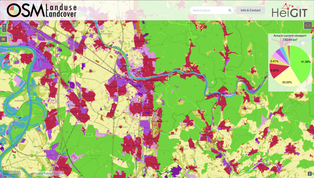
We are pleased to announce that https://osmlanduse.org has received a functionality update. Thanks to the cooperation of GIScience and HeiGIT under the IDEAL-VGI project, our researchers were able to add a number of new features to the interactive map. The map displays OSM land-use and land-cover information.
The two different data layers that made up this unique tool are now available separately for selection using the layers switcher in the top right corner.
-
the current OSM land-use and land-cover information, mapped to CORINE land-cover classes
-
the deep learning based gap-filled version created in 2020 for the EU territory
It is also possible to display both layers at the same time.
In addition, different base-layers are now available. The standard OSM map base layer allows quick visual geolocation, while the new ESRI aerial imagery base layer enables users to compare the land-use information with the “real world” situation. This allows for a visual analysis of the mapping detail, data errors and data completeness. In case you are only interested in the OSM land-use information, you can also turn the base map off.
When zoomed in, a pie-chart depicting class distribution in the current viewport is also available. The update enhances the precision of the chart and adapts to the layer choices of the user. The chart now features the category “missing data” for unmapped areas. This allows fast completeness analyses and region characterizations.
Try it out at https://osmlanduse.org.
Related Works:
-
Jokar Arsanjani, J., Helbich, M., and Bakillah, M.: Exploiting Volunteered Geographic Information To Ease Land Use Mapping Of An Urban Landscape, Int. Arch. Photogramm. Remote Sens. Spatial Inf. Sci., XL-4/W1, 51–55,
ISPRS-Archives – EXPLOITING VOLUNTEERED GEOGRAPHIC INFORMATION TO EASE LAND USE MAPPING OF AN URBAN LANDSCAPE, 2013.
-
Jokar Arsanjani, J., Helbich, M., Bakillah, M., Hagenauer, J., Zipf, A. (2013) Toward mapping land-use patterns from volunteered geographic information. International Journal of Geographical Information Science. 2013. 27(12), 2264-2278. https://doi.org/10.1080/13658816.2013.800871
-
Jokar Arsanjani, J., Mooney, P., Zipf, A., Schauss, A. (2015). Quality Assessment of the Contributed Land Use Information from OpenStreetMap Versus Authoritative Datasets. In: Jokar Arsanjani, J., Zipf, A., Mooney, P., Helbich, M. (eds) OpenStreetMap in GIScience. Lecture Notes in Geoinformation and Cartography. Springer, Cham. https://doi.org/10.1007/978-3-319-14280-7_3
-
Li, H., Ghamisi, P., Rasti, B., Wu, Z., Shapiro, A., Schultz, M., Zipf, A. (2020) A Multi-Sensor Fusion Framework Based on Coupled Residual Convolutional Neural Networks. Remote Sens. 2020, 12(12), 2067. A Multi-Sensor Fusion Framework Based on Coupled Residual Convolutional Neural Networks
-
Schott, M., Lautenbach, S., Größchen, L., and Zipf, A.: OpenStreetMap Element Vectorisation A Tool For High Resolution Data Insights And Its Usability In The Land Use And Land Cover Domain, Int. Arch. Photogramm. Remote Sens. Spatial Inf. Sci., XLVIII-4/W1-2022, 395–402,
ISPRS-Archives – OPENSTREETMAP ELEMENT VECTORISATION – A TOOL FOR HIGH RESOLUTION DATA INSIGHTS AND ITS USABILITY IN THE LAND-USE AND LAND-COVER DOMAIN , 2022.
-
Schott, Moritz, Zell, Adina, Lautenbach, Sven, Demir, Begüm, & Zipf, Alexander. (2022, August 17). Returning the favor – Leveraging quality insights of OpenStreetMap-based land-use/land-cover multi-label modeling to the community. State of the Map 2022 (SotM 2022), Florence, Italy. Returning the favor – Leveraging quality insights of OpenStreetMap-based land-use/land-cover multi-label modeling to the community
-
Schultz, M., Voss, J., Auer, M., Carter, S., Zipf, A. (2017) Open land cover from OpenStreetMap and remote sensing. International Journal of Applied Earth Observation and Geoinformation. 2017, 63, 206-213.
Open land cover from OpenStreetMap and remote sensing

